


Curated Itinerary
Fertő / Neusiedlersee: the Steppe Lake Cultural Landscape
Around Lake Fertő/Neusiedl in six stops: Rust’s storks, Purbach’s walls, the Fertőrákos quarry, Eszterháza’s Haydn rooms and Nagycenk — 120 flat km, ideally by bicycle.
Take this route into Google Maps
From Neusiedl Lake / Fertő-Hanság – Steppe Lake on the Central European Border to Nagycenk, in the order we curated them.
➤ Turn on the navigator in Google MapsIt opens in the Google Maps app with every stop already loaded, in the order we put them in. From there the route is yours: pick how you travel — on foot, by bike, by public transport or by car — change where you start and where you end, drag the stops into a different order, and add places of your own along the way.
This itinerary circles the Fertő / Neusiedlersee cultural landscape, the steppe lake Austria and Hungary have shared on the World Heritage List since 2001. Six stops ring the water: the lake itself and its reed belt, the wine town of Rust with its storks, walled Purbach, the Roman-to-Baroque quarry of Fertőrákos, Haydn’s palace at Eszterháza, and the Széchenyi seat at Nagycenk.
The route is a circuit because the landscape is one: vineyards, reed harvest and palace avenues arranged around a shallow lake that has always ignored the border running through it — most dramatically in 1989, when the Curtain first opened just beyond its southern shore.
Ride it: 120 flat kilometres of signed cycleway make this the easiest two-day tour on CHO, with a ferry shortcut and wine taverns as waypoints. Time it for spring migration or the September harvest, and give Eszterháza its half day.
Read the full story of this route in the CHO Magazine →
Get this route — explore at your own pace
The walk and the notes are open to everyone, right here. To take the route with you — the GPX and KML tracks for your phone — you need a CHO account, and a free one is enough. We do not sell these routes: we build them ourselves and give them to the people who read us.
Create a free accountAlready have one? Log in.
This route was built with the tools we give operators.
Guides, associations and cultural operators build their own routes here: pick the stops from the archive, add your notes, and the map, the GPX and the printable version come out on their own. Your programme gets a permanent page, your events go on the city pages people read while planning — and if you sell your route as a road-book or a virtual tour, you receive 80% of the price net of tax.
See how an operator account worksBefore you go
A word from your host
Rent the bike. The lake ring is flat, signed and punctuated by wine taverns exactly where your legs want them. Cross the border both ways in one afternoon just because, for forty years, nobody here could.
Getting around
Vienna is an hour away; the 120-km lakeside cycleway circles the whole property with rental stations in every town and a ferry shortcut across the middle. Drivers manage all six stops in a long day, but the landscape rewards two.
Step by step
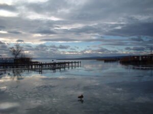
Neusiedl Lake / Fertő-Hanság – Steppe Lake on the Central European Border
On the flat plain where the Alps end and the Pannonian steppe begins, a body of water 36 kilometres long and up to 15 kilometres wide spreads beneath an…

Rust, Burgenland
Austria's smallest statutory city, granted royal free city status in 1681.

Purbach am Neusiedlersee
A wine-producing Austrian town on the western shore of Neusiedler See, Europe's only steppe lake without natural outflow.

Fertőrákos
A frontier village in northwestern Hungary where a Roman mithraeum, contested 1921 plebiscite, and World War II labour camp memorial mark competing…

Eszterháza
A Rococo palace in Fertőd built by Prince Nikolaus Esterházy, Eszterháza was home to composer Joseph Haydn from 1766 to 1790 and is Hungary's grandest…

Nagycenk
A village in northwestern Hungary near Sopron and Lake Fertő, positioned on the Austrian border in Győr-Moson-Sopron county.
Download for tour navigation
🔒 The walk and the notes are open to everyone on this page. The files to take with you — the stop list as a PDF, and the GPX and KML tracks for your phone — come with a CHO account, and the free one includes them.
Walk it with the navigator on
It opens in the Google Maps app with every stop already loaded, in the order we put them in. From there the route is yours: pick how you travel — on foot, by bike, by public transport or by car — change where you start and where you end, drag the stops into a different order, and add places of your own along the way.