
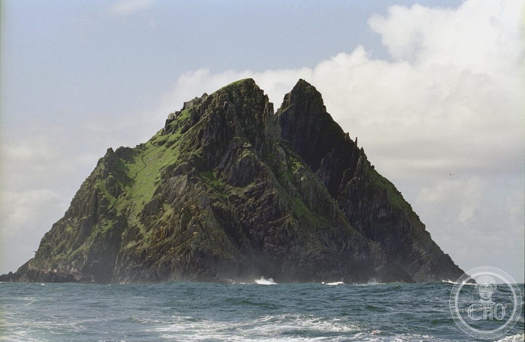
A pyramid of Atlantic sandstone rising sheer from the sea off the Kerry coast, Skellig Michael carries one of the most isolated early Christian monasteries ever built. Monks lived here for centuries in dry-stone beehive cells reached by hundreds of hand-carved steps, in a place still shaped almost entirely by wind, rock and ocean.
At a glance
Skellig Michael, known in Irish as Sceilig Mhichíl and dedicated to the Archangel Michael, rises 218 metres out of the Atlantic off the Iveragh Peninsula in County Kerry. The island is formed of Old Red Sandstone laid down in the Devonian period, roughly 370 million years ago. It is the larger of the two Skellig islands; its neighbour, Small Skellig, is uninhabited and holds one of the largest Atlantic gannet colonies in the world, with tens of thousands of breeding birds.
Key facts
- Height: the island rises 218 metres above sea level; the monastery itself sits at around 183 metres on the south peak.
- Monastic remains: six intact dry-stone beehive cells, two oratories, a cemetery, terraced garden plots and a hermitage.
- Construction: the buildings use a corbelling technique, overlapping stones laid without mortar that has kept the cells watertight for centuries.
- Access route: roughly 600 stone steps cut into the rock face by the monks, largely unaltered and mostly without handrails.
- Viking raids: the monastery was attacked in 821 CE, when the abbot Étgal was taken captive and died in captivity, and again in 824 CE.
- Wildlife: the island supports a large Atlantic puffin colony, with puffins nesting in burrows dug into the monastery terraces.
- On screen: the island appeared as Ahch-To in Star Wars: The Force Awakens (2015, directed by J.J. Abrams) and Star Wars: The Last Jedi (2017, directed by Rian Johnson).
History
The earliest written references place monks on Skellig Michael from the 6th century CE, and tradition credits the founding of the settlement to Saint Fionán of Kinnitty. The community endured two Viking raids, in 821 and 824 CE, during the first of which the abbot Étgal was taken prisoner and died of hunger in captivity.
By the late 12th century the monks had left the exposed rock for the mainland abbey at Ballinskelligs, a move generally linked to worsening conditions as the Medieval Warm Period came to an end and life on the summit became harder to sustain.
The site was inscribed as a UNESCO World Heritage Site in 1996.
What you see
The monastery is laid out across three terraces cut into the south peak. The lower terraces hold the beehive cells where monks lived and worked; the upper terrace carries the smaller oratories and, at the very summit, the hermitage. Two boat-shaped oratories survive, along with carved stone crosses regarded as fine examples of early Irish Christian stonework. The hermitage at the south peak lies along an exposed ridge and is not part of the standard visitor route.
Practical information
- Season: boats operate only between May and October, weather permitting, and trips are frequently cancelled when the Atlantic is rough.
- Booking: places are limited and landing permits are required, so early booking through an authorised boat operator is advisable.
- What to bring: sturdy hiking boots are strongly recommended, as the stone steps are steep, uneven and largely without handrails.
- Fitness: the climb to the monastery requires a reasonable level of fitness and a good head for heights.
Getting there
Skellig Michael can only be reached by boat, with departures from Portmagee, Ballinskelligs or Cahersiveen in County Kerry. Kerry itself is reachable by road from Cork or Dublin, or by air via Kerry Airport. Boat schedules and availability should be confirmed directly with operators, since sailings depend entirely on sea conditions.
Nearby
- Ring of Kerry / Iveragh Peninsula — the scenic coastal route surrounding Skellig Michael’s mainland access points.
- Killarney National Park — Ireland’s first national park, home to Muckross Abbey, Torc Waterfall and the country’s only native red deer herd.
- MacGillycuddy’s Reeks — Ireland’s highest mountain range, reaching 1,038 metres at Carrauntoohil.
- Newgrange — a Neolithic passage tomb built around 3200 BC, part of the Brú na Bóinne complex, roughly 320 km northeast and itself a UNESCO World Heritage Site since 1993.
- Cliffs of Moher — an 8 km stretch of Atlantic cliffs with its own puffin colony, around 200 km to the north.
- The Burren — a karst limestone plateau where Alpine and Mediterranean plant species grow side by side.
Sources
- Wikipedia, Skellig Michael
- Wikipedia, Small Skellig
- Wikipedia, Beehive hut
- UNESCO, Sceilg Mhichíl, World Heritage List reference 757
Find it on the map
See this place and what’s around it →📷 Become a Cultural Heritage Online photographer
Share your photos of places: they stay published under your name as the author. The more they're seen, the more you get noticed — and soon a contest will reward the most appreciated photos.
Log in or sign up free to add a photo