
Virtual Tour
Buddhist Temple Route: Bodh Gaya to Borobudur
The Buddhist Temple Route traces the southward and eastward spread of Buddhist architecture from mainland Southeast Asia into the Indonesian archipelago…
Take this route into Google Maps
From Bodh Gaya – Virtual Tour 360° to Borobudur – Virtual Tour 360°, in the order we curated them.
➤ Open the stops in Google MapsThese places are spread over thousands of kilometres, and Google will not always join them into one route. It opens with the stops loaded in our order: from there pick two that are close to each other, choose how you travel, and add places of your own. For a single leg, the directions on each stop's own page work better.
The Buddhist Temple Route traces the southward and eastward spread of Buddhist architecture from mainland Southeast Asia into the Indonesian archipelago — four UNESCO World Heritage Sites, four countries, one of the most sustained experiments in religious building the world has ever seen.
The route runs from Bagan in Myanmar south through Sukhothai in Thailand, across to Angkor in Cambodia, and then by flight to Borobudur in central Java, Indonesia. Each site is a monument to the extraordinary capacity of Buddhist thought to generate architecture on a monumental scale, adapted to local climate, material and political context.
Stage 1 — Bagan (Myanmar)
Between the 9th and 13th centuries, the rulers of the Pagan Kingdom built more than 10,000 Buddhist temples, pagodas and monasteries across the plain of Bagan. Around 3,500 survive. They range from intimate brick shrines to the Ananda Temple — an 11th-century Mon-style masterpiece with four standing gilded Buddha figures and a whitewashed exterior that glows at dusk like a lantern.
Bagan was declared a UNESCO World Heritage Site in 2019. The most atmospheric experience remains at sunrise from the top of a temple, watching the pagoda silhouettes emerge from morning mist. The 2016 earthquake damaged many structures; conservation work is ongoing. Light in October–February, when the plains are green after the rains, is exceptional.
Stage 2 — Sukhothai (Thailand)
Sukhothai Historical Park preserves the ruins of the 13th-century capital of the first major Thai kingdom. The site synthesises Buddhist architecture with Khmer and Sri Lankan influences: lotus-bud spires, large seated Buddha images in the Maravijaya mudra, and an urban plan of concentric moats and walls still readable in the flat landscape.
The key monument is Wat Mahathat, the central royal temple. Cycling through the park at dawn — when the site is quiet and stone reflects the low light — is one of the most pleasurable ways to read a historical landscape in Southeast Asia.
Stage 3 — Angkor (Cambodia)
Angkor Wat is the largest religious monument ever built: a 9th-to-15th-century capital of the Khmer Empire covering roughly 400 square kilometres. Built as a Hindu temple dedicated to Vishnu, it was converted to Theravada Buddhism in the 13th century — a transition visible in its bas-reliefs and pediments.
The face-towers of the Bayon (with 216 serene giant faces carved on its towers) are among the most reproduced images in Asian archaeology. The Angkor Archaeological Park contains over 1,000 temples across jungle and rice paddy. Allow at least three days: the outer circuit takes a full day; the inner temples another; the more remote monuments, a third.
Stage 4 — Borobudur (Indonesia)
Borobudur on the island of Java was built in the 9th century CE under the Sailendra dynasty and is the world’s largest Buddhist monument. Its plan is a mandala — a cosmological map of the Buddhist universe — rendered in stone: nine stacked platforms rising 35 metres, decorated with 2,672 relief panels and 504 Buddha statues.
The reliefs narrate episodes from the Jataka tales in a continuous frieze stretching nearly five kilometres. Walking the monument clockwise from base to summit replicates the Buddhist journey from the world of desire through form to formlessness. Borobudur was rediscovered in 1814 and restored by UNESCO and the Indonesian government between 1975 and 1982.
Practical Notes
- Duration: 10–14 days for the full route with transit time
- Best season: November–April (dry season across most of the route)
- Logistics: Fly Bangkok or Yangon as a hub; Angkor is served by Siem Reap airport; Borobudur is 40km from Yogyakarta
- Note: Bodh Gaya and Sarnath (India origin sites) are being added to the CHO catalogue and will extend this route northwestward
- GPS files: Download the GPX or KML for OsmAnd, Garmin, or Google Earth
Get this route — explore at your own pace
The walk and the notes are open to everyone, right here. To take the route with you — the GPX and KML tracks for your phone — you need a CHO account, and a free one is enough. We do not sell these routes: we build them ourselves and give them to the people who read us.
Create a free accountAlready have one? Log in.
This route was built with the tools we give operators.
Guides, associations and cultural operators build their own routes here: pick the stops from the archive, add your notes, and the map, the GPX and the printable version come out on their own. Your programme gets a permanent page, your events go on the city pages people read while planning — and if you sell your route as a road-book or a virtual tour, you receive 80% of the price net of tax.
See how an operator account worksStep by step

Bodh Gaya – Virtual Tour 360°
The holiest site in Buddhism, where Gautama Buddha attained enlightenment. Bodh Gaya has welcomed pilgrims for over two millennia in Bihar's Gaya district.

Sarnath
Sarnath, the Deer Park near Varanasi, is where Gautama Buddha delivered his first teaching around 528 BCE—one of Buddhism's eight most sacred pilgrimage sites.

Bagan – Virtual Tour 360°
An ancient Buddhist capital where over 2,200 temples and pagodas rise from the plains, testament to the Pagan Kingdom's spiritual and political dominion…
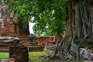
Ayutthaya Historical Park – Virtual Tour 360°
For 417 years (1351–1767) the capital of the Kingdom of Ayutthaya — the dominant political power of mainland Southeast Asia, which at its peak governed a…
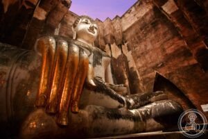
Sukhothai Historical Park – Virtual Tour 360°
The ruined first capital of the Thai kingdom, where the Thai alphabet and the walking Buddha image were created, set across a moated park of temples founded around 1238.
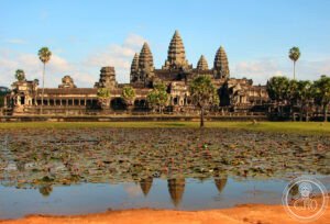
Angkor – Virtual Tour 360°
The largest religious monument ever built and the defining achievement of Southeast Asian civilisation — Angkor, the capital of the Khmer Empire from the 9th…
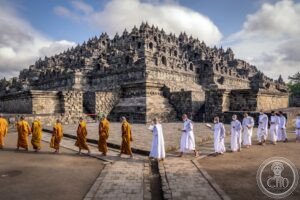
Borobudur – Virtual Tour 360°
Borobudur is a ninth-century stone mandala on Java's Kedu Plain, its galleries carrying thousands of relief panels tracing the Buddhist path to enlightenment.
Download for tour navigation
🔒 The walk and the notes are open to everyone on this page. The files to take with you — the stop list as a PDF, and the GPX and KML tracks for your phone — come with a CHO account, and the free one includes them.
Walk it with the navigator on
These places are spread over thousands of kilometres, and Google will not always join them into one route. It opens with the stops loaded in our order: from there pick two that are close to each other, choose how you travel, and add places of your own. For a single leg, the directions on each stop's own page work better.