

Aprilia — Rationalist New Town
The fourth of the Fascist-era new towns built on the reclaimed Pontine plain south of Rome, designed by the “2PST” team of Concezio Petrucci, Emanuele Filiberto Paolini, Riccardo Silenzi and Mario Tufaroli — reduced to rubble in the 1944 Anzio battle and rebuilt around its surviving civic core.
At a glance
Aprilia is a comune in the province of Latina, on the agricultural plain between Rome and the Tyrrhenian coast. It was the fourth of five purpose-built towns the Fascist regime laid out across the reclaimed Pontine marshes between 1932 and 1939, after Littoria (today Latina), Sabaudia and Pontinia. Its foundation stone was laid on 25 April 1936 to a competition-winning master plan signed by four young architects working under the acronym “2PST.” In January 1944, eight years later, the town stood directly on the Allied beachhead from Anzio and was reduced — in the Allied designation “the Factory” — to a field of ruins. What visitors read today is the post-war reconstruction of a Rationalist plan, with the original 1936 buildings either restored, replaced, or remembered only in plan.
Key facts
- Location: Province of Latina, Lazio — 31 km south of Rome, 16 km inland from Anzio
- Coordinates: 41.5917° N, 12.6700° E
- Founded: 25 April 1936; inaugurated 29 October 1937
- Master plan: Group 2PST — Concezio Petrucci, Emanuele Filiberto Paolini, Riccardo Silenzi, Mario (Mosè) Tufaroli
- Order of foundation: fourth Pontine new town, after Littoria (1932), Sabaudia (1934) and Pontinia (1935)
- Founding buildings: Town Hall, Post Office, Church of San Michele Arcangelo, Casa del Fascio
- City status: awarded by Presidential decree on 29 October 2012
History
The land Aprilia occupies belonged in antiquity to Ardea and then to Rome, but for most of recorded history it was wetland: malarial, sparsely cultivated, periodically drained and abandoned. Systematic reclamation began in 1929 under the Mussolini government’s “bonifica integrale,” combining deforestation, marsh drainage and the parcelling of new farms of four to twelve hectares. Settlers came from the alpine north — Trentino, the Veneto, Friuli and Emilia-Romagna — recruited to populate a landscape that had been emptied for centuries.
The town itself was conceived as the urban anchor for that agrarian project. The winning master plan came from a young Roman team that signed itself 2PST from the initials of Petrucci, Paolini, Silenzi and Tufaroli. Their scheme, simpler and more axial than Sabaudia’s, organised the settlement around a single ceremonial square with the four institutional functions — civic, postal, religious, political — arranged on its edges. The foundation ceremony took place on 25 April 1936; the inauguration followed on 29 October 1937. The name “Aprilia” was drawn from the Latin epithet of Venus Aprilia, “the fruitful.”
The town’s eight peaceful years ended in January 1944. The Allied landing at Anzio on 22 January placed Aprilia squarely on the contested beachhead, and the German counter-attack made the small urban centre — nicknamed “the Factory” by Allied troops for the silhouette of its buildings — a strategic objective. By the time the front moved north in late May, the population had fled to Campania and Calabria and the town had been pulverised. Reconstruction in the late 1940s and 1950s restored the surviving civil buildings, redesigned the Town Hall, demolished the Casa del Fascio in the 1970s, and rebuilt the bell tower of San Michele Arcangelo in 1999. From 1951 onward, with the arrival of the Simmenthal plant, Aprilia’s identity shifted from agricultural service centre to industrial town — today it hosts roughly a hundred factories.
What you see
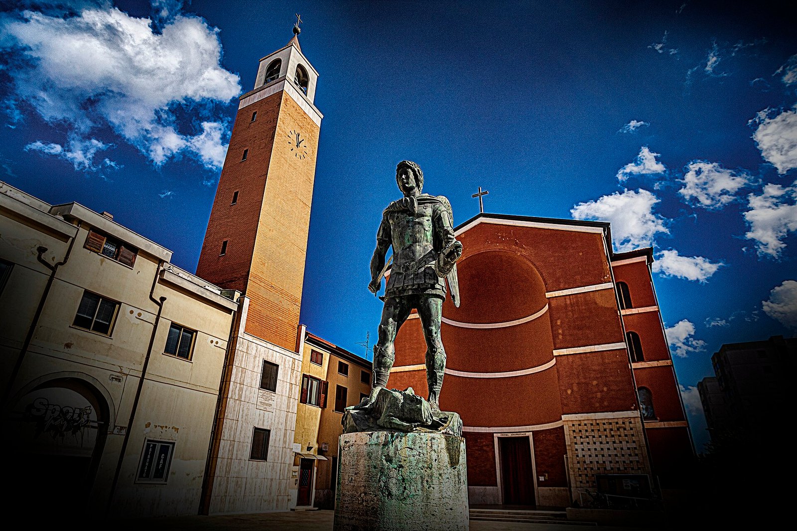
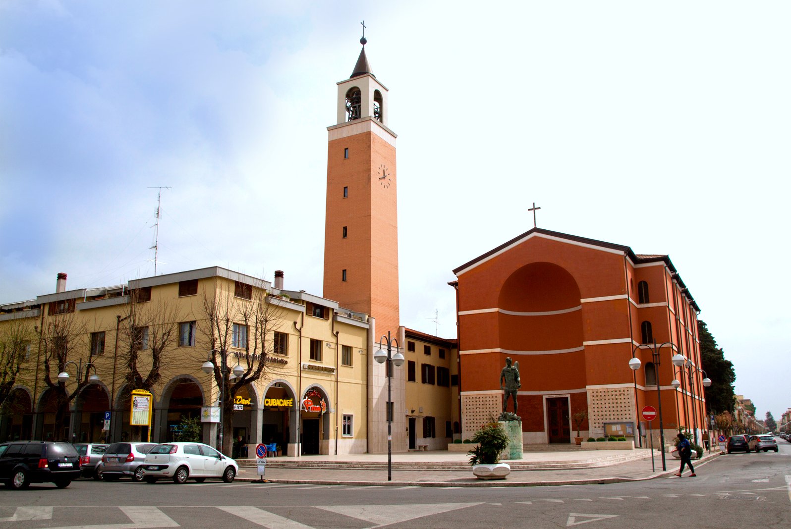
The 2PST plan survives in outline more than in fabric. The central square still works as the focal void the architects intended, but the four buildings around it have all been altered: the original Town Hall was rebuilt after the war on a modified footprint, the Casa del Fascio was demolished in the 1970s and replaced, the Post Office restored, and the parish church of San Michele Arcangelo — struck repeatedly during the 1944 battle — rebuilt with a new bell tower in 1999. The statue of San Michele in the churchyard still carries shrapnel marks from the fighting.
The Rationalist legibility of the 1936 design is therefore best read in the urban geometry rather than the elevations: the axial relationship between square, church and civic building, the deliberate sobriety of the volumes, the absence of the historicist gestures common to other Fascist new towns. Outside the centre, in the frazione of Carano, the Mausoleo della famiglia Garibaldi holds the remains of Menotti Garibaldi, who lived locally until his death in 1903.
Practical information
- Opening: the town centre is freely walkable. The church of San Michele Arcangelo is open during liturgical hours.
- Best season: spring and autumn. July and August on the Pontine plain are hot and humid; winter is mild but often grey.
- Time needed: half a day for the founding core (central square, church, civic axis); a full day if combined with Anzio and the Beachhead Cemetery.
- Pair with: the other three earlier Pontine new towns — Latina, Sabaudia, Pontinia — for a coherent reading of the 1930s reclamation programme.
Getting there
Aprilia sits on the Rome–Nettuno regional railway (FL8): from Roma Termini the journey takes about 40 minutes. By car, the SS148 Pontina and the SS207 Nettunense both serve the town; from central Rome it is roughly 45 minutes off-peak. The nearest airport is Roma Fiumicino (FCO), about 50 km north-west.
Nearby
- Aprilia Founded Town Walk — the curated itinerary, with map and GPX.
- Aprilia, 1937 — the dedicated magazine article by Stefano Vigolo.
- Church of San Michele Arcangelo — inaugurated with the town in 1937, destroyed in 1944, rebuilt.
- Anzio — landing beaches and the Sicily–Rome American Cemetery, 16 km south.
- Nettuno — medieval borgo and Sanctuary of Santa Maria Goretti, 18 km south.
- Latina — first and largest of the Pontine new towns (founded 1932), 30 km south-east.
- Sabaudia — the most architecturally celebrated of the new towns, on the coastal lake (1934), 60 km south.
Image gallery
Sources
- Wikipedia (English), “Aprilia, Lazio” — foundation, 2PST team, Battle of Anzio narrative.
- Decreto del Presidente della Repubblica, 29 October 2012 — conferral of the title of Città.
- Antonio Pennacchi, Fascio e Martello. Viaggio per le città del Duce, Laterza 2008 — on the Pontine new-town programme.
- Comune di Aprilia, official communications on the 1999 reconstruction of the San Michele bell tower.
Find it on the map
See this place and what’s around it →📷 Diventa un fotografo di Cultural Heritage Online
Condividi le tue foto dei luoghi: restano pubblicate con la tua firma come autore. Più vengono viste, più ti fai conoscere — e presto un concorso premierà le foto più apprezzate.
Accedi o registrati gratis per aggiungere una foto