
Curated Itinerary
Aprilia Founded Town Walk — 1937, Destroyed and Rebuilt
Aprilia was the fourth of the new towns built on the reclaimed Pontine plain south of Rome, founded in 1937 to a design by the 2PST team — Petrucci, Tufaroli, Paolini, Silenzi. Seven years later the Anzio front line ran straight through it and the town was destroyed; it was rebuilt afterwards over its own plan. Two stops hold that story. The first is the town itself, as a piece of design that outlived its own buildings. The second is the church of San Michele Arcangelo: inaugurated with the town in 1937, ruined with it in 1944, raised again on the same ground. Three kilometres on foot, and really one question — what survives of a plan when the stones that carried it are gone. Stefano Vigolo tells the full story in a separate article.
Take this route into Google Maps
From Aprilia — Rationalist New Town by Petrucci, Tufaroli, Paolini, Silenzi to Church of San Michele Arcangelo, Aprilia — Built 1937, Destroyed 1944, Rebuilt, in the order we curated them.
➤ Turn on the navigator in Google MapsIt opens in the Google Maps app with every stop already loaded, in the order we put them in. From there the route is yours: pick how you travel — on foot, by bike, by public transport or by car — change where you start and where you end, drag the stops into a different order, and add places of your own along the way.
Aprilia (1937), the founded town destroyed on the Anzio front line in 1944 and rebuilt over its own plan, with the church of San Michele Arcangelo. Read the full story in the dedicated article Aprilia, 1937: a Founded Town Destroyed and Rebuilt, by Stefano Vigolo.
Step by step
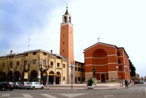
Aprilia — Rationalist New Town by Petrucci, Tufaroli, Paolini, Silenzi
The fourth of the Fascist-era new towns built on the reclaimed Pontine plain south of Rome, designed by the “2PST” team of Concezio Petrucci, Emanuele…
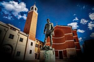
Church of San Michele Arcangelo, Aprilia — Built 1937, Destroyed 1944, Rebuilt
Inaugurated with the town in 1937, destroyed with it in 1944: the church of Aprilia is the fourth new town's story in a single building — founded, ruined…
Download for tour navigation
PDF is the stop list with GPS, to print or keep on the phone. GPX for Garmin / Komoot / OsmAnd. KML for Google Earth and Maps.
Walk it with the navigator on
It opens in the Google Maps app with every stop already loaded, in the order we put them in. From there the route is yours: pick how you travel — on foot, by bike, by public transport or by car — change where you start and where you end, drag the stops into a different order, and add places of your own along the way.
To keep the route in the app instead of opening it once, download the KML above and import it into Google My Maps — Create a new map, then Import: the route then sits among your own maps in Google Maps, with the stops and our notes attached to each one.