

Curated Itinerary
The Camino Francés: from the Pyrenees to Santiago
The heritage spine of the Camino Francés: Pyrenean passes, pilgrim bridges, the cathedrals of Burgos and León, Gaudí at Astorga, and the granite finale at Santiago.
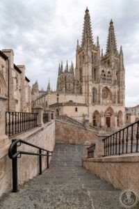
This itinerary follows the Camino Francés, the classic line of the UNESCO-listed Routes of Santiago de Compostela (Spain 1993, French routes 1998): roughly eight hundred kilometres from Saint-Jean-Pied-de-Port over the Pyrenees to the cathedral of Santiago. Fifteen stops mark its heritage spine — pilgrim bridges and hospital towns, the cathedral trio of Burgos, León and Santiago, Gaudí’s Astorga palace, the iron cross of Foncebadón and the fog-bound hamlet of O Cebreiro.
The sequence is the walker’s own, west by daily stages; but the route serves drivers equally, as the towns line up along parallel modern roads. What connects the stops is function: everything here — bridge, church, hostel, town plan — was built to move people west and keep them alive doing it.
Walk it in five to six weeks, drive it in under a week, or walk the last hundred kilometres from Sarria past Samos for the certificate. Book beds ahead outside winter, and let the cathedrals set each day’s timetable.
Before you go
A word from your host
You do not have to walk it all — but walk some of it. Two hours on the path out of any stop teaches more about this listing than every cathedral combined. And leave a stone at the Cruz de Ferro; the pile is a thousand years of other people's reasons.
Getting around
Walkers: five to six weeks whole, one week from Sarria for the Compostela. Drivers: the N-120 corridor touches every stop in five days. Spring and September are the seasons; the credencial opens the pilgrim hostels.
Step by step




Download for tour navigation
GPX for Garmin / Komoot / OsmAnd. KML for Google Earth and Maps.