Yazilikaya
Two kilometres from the Hittite capital Hattusa, two natural rock chambers whose walls were carved with 90 relief figures of gods constitute the largest known gallery of Hittite religious art and the primary outdoor sanctuary of the Hittite state religion — an open-air temple where the divine assembly was believed to gather physically each spring.
At a glance
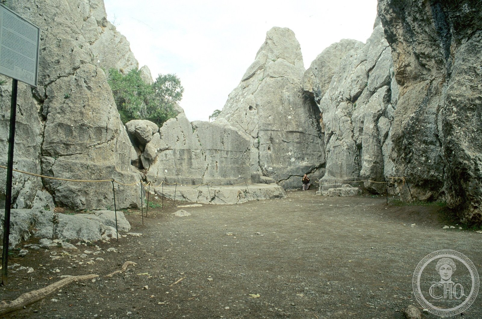
Yazili kaya (“Inscribed Rock” in Turkish) is an outdoor rock sanctuary 2 km northeast of the Hittite capital Hattusa in north-central Turkey. Two natural rock chambers — Chamber A (the larger, main sanctuary) and Chamber B (smaller, more private) — have walls carved with approximately 90 deities in shallow relief, identified by cuneiform inscriptions in Hieroglyphic Luwian above their heads. The site served as the primary state sanctuary of the Hittite Empire and was likely the venue for the most important annual religious festival of the Hittite calendar. It forms part of the UNESCO World Heritage inscription of Hattusa (1986).
Key facts
- Location: 2 km northeast of Hattusa (Bogazkoy), Corum Province, north-central Turkey
- Period: c. 1400-1200 BC (Hittite Empire, peak use under Tudhaliya IV, c. 1237-1209 BC)
- Script: Hieroglyphic Luwian inscriptions identifying each deity
- UNESCO WHS: 1986, as part of the Hattusa inscription, criteria (i)(ii)(iii)(iv)
- Total reliefs: Approximately 90 divine figures across both chambers
- Chief deity: Teshub (storm god) in Chamber A; Nergal-Sharruma in Chamber B
History
Yazili kaya developed during the height of the Hittite Empire in the 13th century BC, though some elements may date to the 15th century. The sanctuary reached its definitive form under Tudhaliya IV (c. 1237-1209 BC), the Hittite Great King who appears to have invested particular personal devotion in the site: the most intimate religious image in Chamber B — a relief of the god Nergal-Sharruma embracing Tudhaliya IV, with the king shown at roughly half the god’s height — is almost certainly a reference to direct divine patronage of the king. Whether Chamber B served as Tudhaliya’s own funerary chapel remains debated; the combination of an underworld iconographic programme with royal imagery makes the funerary interpretation compelling to many scholars.
The Hittite Empire collapsed around 1200 BC in the broader Late Bronze Age collapse that destroyed palace cultures across the eastern Mediterranean. Hattusa was burned and abandoned. Yazili kaya fell into disuse and was gradually buried under soil until rediscovery by Charles Texier in 1834, who recognised it as a major ancient site. Systematic excavation began in the late 19th century and continued through the 20th century under German and Turkish teams.
What you see
Chamber A is the main sanctuary: a roughly trapezoidal open-air enclosure formed by natural rock walls 10-12 metres high, its surfaces carved with the divine procession. Approximately 65 deities file in two converging columns towards the north wall, where the storm god Teshub and the sun goddess Hepat meet face to face — both at approximately 2-metre scale, the largest figures in the chamber. Teshub stands on two subjugated mountain gods; Hepat stands on a walking leopard. Around them crowd their divine retinue: gods in pointed shoes with upturned toes, conical caps, and short robes, each carrying their symbolic attribute (spear, club, solar disc). The inscriptions above each figure identify them by name in Hieroglyphic Luwian, making Chamber A essentially an annotated divine genealogy carved into stone.
Chamber B is narrower and more dramatic. Its most striking figure is the “dagger god”: an anthropomorphic deity whose torso and head emerge from the hilt of an enormous blade, the lower body replaced entirely by the sword — a visual embodiment of divine lethal power. Twelve identical figures in marching formation represent the “Twelve Gods of the Underworld,” bearing curved swords, thought to guard the Hittite afterlife. The relief of the god embracing King Tudhaliya IV occupies the central position: the god’s arm encircles the king’s shoulder in a gesture simultaneously protective and proprietorial, the scale differential (king at half god’s height) making the power relationship explicit. A cartouche of Tudhaliya IV appears at the exit of the chamber.
The Hittite sacred calendar
Hittite religious texts describe an annual festival — the purulli festival, associated with the spring equinox and the victory of Teshub over the serpent Illuyanka — that may have been the occasion for which Yazili kaya was the primary venue. The convergence of the divine procession towards the meeting of Teshub and Hepat in Chamber A would have provided a theatrical backdrop for rituals re-enacting this cosmic victory. The Hittites believed the gods gathered physically at Yazili kaya at this time; the sanctuary gave the divine assembly a permanent visible form on rock that persisted between festivals, anchoring the gods’ presence in the landscape.
Practical information
- Opening hours: Daily, 08:00-19:00 (summer) / 08:00-17:00 (winter); check locally for current hours
- Combined ticket: Entry is typically combined with Hattusa archaeological zone
- Photography: Permitted; no flash on relief surfaces
- Accessibility: Uneven rock paths; Chamber B involves a narrow passage — not fully wheelchair-accessible
- Guided tours: Local guides available at the Hattusa site entrance and in Bogazkale village
Getting there
Yazili kaya is 2 km northeast of the Hattusa archaeological zone (Bogazkoy/Bogazkale), in Corum Province. The nearest city is Corum (approximately 80 km), accessible by bus from Ankara. Most visitors base themselves in Sungurlu or use a day trip from Ankara (approximately 200 km) or Samsun. From the Hattusa car park, Yazili kaya is reachable on foot in approximately 30 minutes or by car via a signed road. The two sites are typically visited together in a single day.
Nearby
- Hattusa — the Hittite capital, 2 km from Yazili kaya; Lion Gate, Sphinx Gate, Great Temple
- Alacahoyuk — Bronze Age Hattian site with royal tombs, 25 km from Bogazkale
- Sapinuwa (Ortakoy) — Hittite administrative centre with cuneiform archive, 65 km from Bogazkale
Sources
- UNESCO World Heritage List — Hattusa: the Hittite Capital (1986)
- Bittel, Kurt — Hattuscha: Hauptstadt der Hethiter, DuMont (1983)
- Neve, Peter — Yazilikaya: Baudenkmaeler und Bildwerke, Wasmuth (1971)
- Bryce, Trevor — The Kingdom of the Hittites, Oxford University Press (1998)
- Wikipedia — Yazilıkaya
Find it on the map
See this place and what’s around it →📷 Diventa un fotografo di Cultural Heritage Online
Condividi le tue foto dei luoghi: restano pubblicate con la tua firma come autore. Più vengono viste, più ti fai conoscere — e presto un concorso premierà le foto più apprezzate.
Accedi o registrati gratis per aggiungere una foto