Ek Balam — The Maya City with the World’s Finest Intact Stucco Facade
In the jungle of northeastern Yucatán, the Maya city of Ek Balam contains a burial chamber facade of such extraordinary sculptural quality — preserved for 1,000 years under rubble fill — that it stands comparison with the finest Baroque sculpture in Europe.
At a glance
Ek Balam (Black Jaguar in Yucatec Maya) flourished during the Late and Terminal Classic periods (600–1100 AD) as a major city in northeastern Yucatán. Its Acropolis pyramid reaches 31 metres in height and 160 metres in length, making it one of the largest structures in the Maya world. But the site’s exceptional importance rests on a discovery made only in 1987: the main facade of the Acropolis’s largest platform was found still intact beneath a rubble fill that had protected its three-dimensional polychrome stucco sculpture from the elements for approximately 1,000 years. The facade, centred on an enormous fanged monster-mouth doorway and featuring the deified ruler Ukit Kan Le’k Tok’ as a winged jaguar figure approximately 3 metres tall, is the finest surviving example of Classic Maya architectural sculpture — its detail, surface modelling, and traces of original polychrome paint preserved at a level unmatched at any other Maya site.
Key facts
- Location: 30km north of Valladolid, Yucatán state, Mexico; coordinates 20.8875°N, 88.2428°W
- Height of Acropolis: 31 metres; one of the largest Maya structures in Yucatán
- Facade discovery: 1987 excavation revealed the intact stucco facade of Structure 1 Level II
- Central figure: Ukit Kan Le’k Tok’, deified ruler depicted as a winged jaguar deity, approximately 3m tall
- Conservation: Protected by a roof structure; only the tomb interior accessible by prior arrangement
- Site management: INAH (Instituto Nacional de Antropología e Historia) archaeological zone; entrance fee required
- Nearest town: Temozón, 5km; Valladolid, 30km (colonial city with hotels and restaurants)
History
Ek Balam was occupied from at least the Preclassic period (300 BC) and reached its apogee between approximately 600 and 900 AD, when it controlled a substantial territory in northeastern Yucatán independent of the major centres of Chichen Itza (approximately 50km to the southwest) and Cobá. The city’s political structure centred on a dynasty of rulers whose inscriptions — discovered during INAH excavations beginning in the 1980s — name its kings and record the political events of its florescence. The most important ruler was Ukit Kan Le’k Tok’ (reigned c. 770–801 AD), whose apotheosis is celebrated in the Acropolis facade. His name, which can be translated as Precious/Sacred Flint with a title invoking the jaguar, is preserved in hieroglyphic inscriptions flanking the facade entrance and within the tomb itself.
The key event in Ek Balam’s modern archaeological history was the 1987 excavation season led by INAH archaeologist William Ringle, during which workers clearing accumulated rubble from the front of the Acropolis’s main platform began uncovering fragments of intact polychrome stucco sculpture at a depth that indicated the entire facade had been deliberately buried — almost certainly as a funerary offering to the entombed ruler, or as a protective measure when the city was abandoned. The excavation revealed the facade to be not a simple decorative surface but an elaborate three-dimensional sculptural programme covering approximately 6 metres of height: the monster-mouth doorway (representing the entrance to Xibalba, the Maya Underworld), the central winged figure of the deified Ukit Kan Le’k Tok’, flanking figures of crouching supernatural beings, skull masks, scrollwork, and rows of smaller figures in various postures, every surface carved in wet plaster to a depth and detail extraordinary for a material as fragile as lime stucco.
After approximately 900 AD Ek Balam declined, though occupation continued into the Postclassic period. The city was never entirely abandoned before Spanish contact and may have been a functioning settlement at the time of the Conquest. Its relative obscurity in the colonial period — it does not appear in the early Spanish sources that describe Chichen Itza and Uxmal in detail — allowed its monuments to survive largely intact under the jungle canopy.
What you see
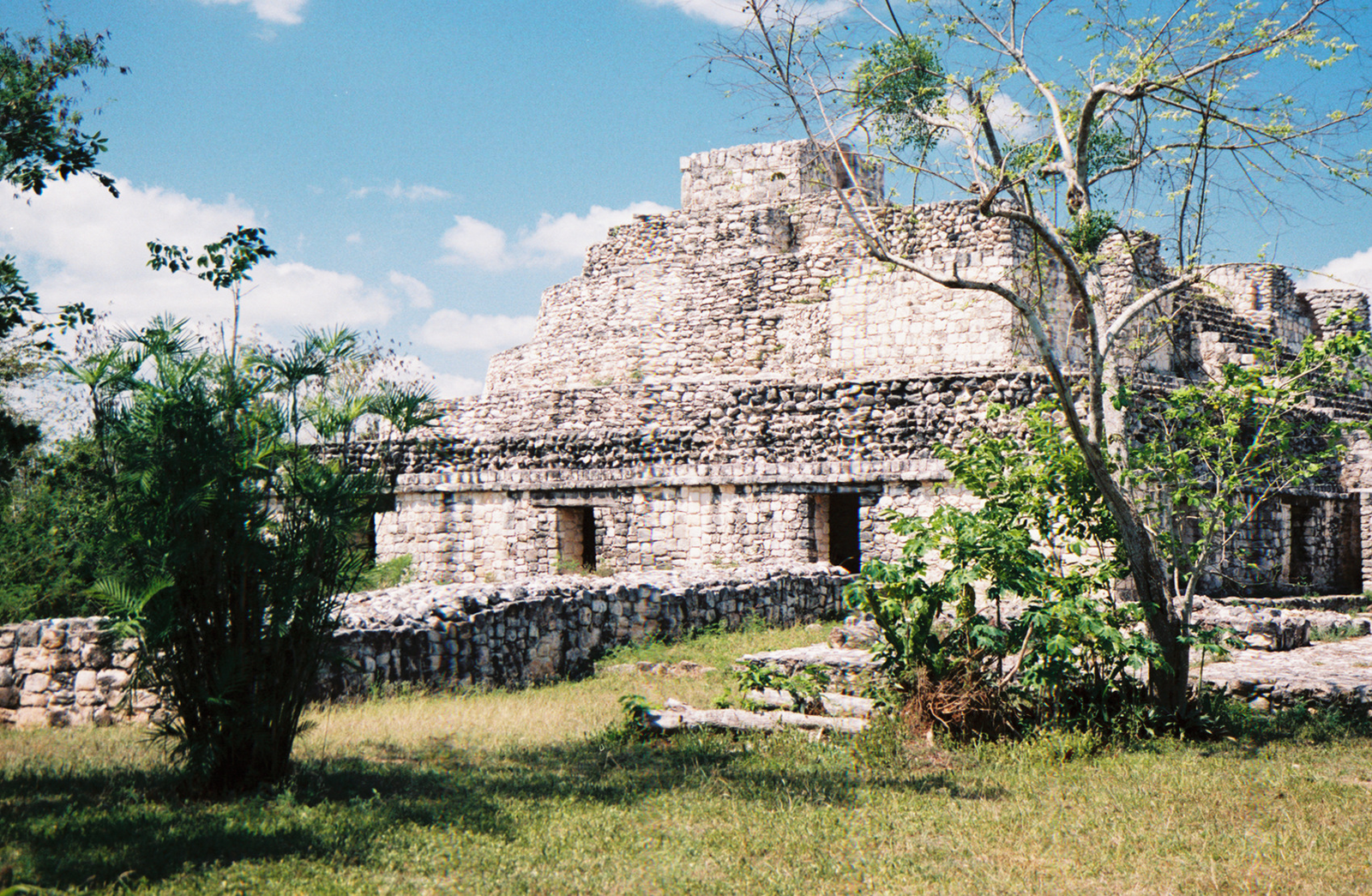
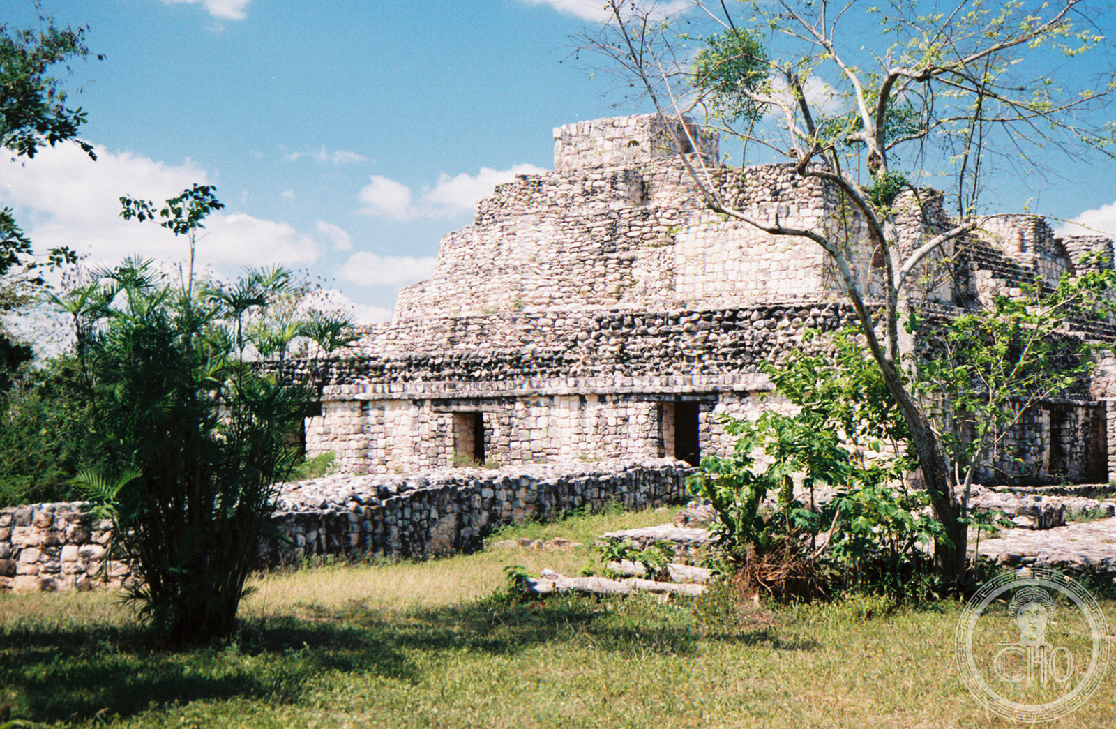
The Acropolis — the central and defining structure of Ek Balam — is an elongated platform pyramid built in multiple phases, running roughly north–south for approximately 160 metres and reaching 31 metres at its highest point. The main facade of Structure 1, Level II faces west and occupies the middle section of the pyramid’s south side. The monster-mouth entrance — approximately 3.5 metres wide and 2 metres tall at the centre of the facade — is framed by the upper and lower jaws of a massive fanged face, with rolled stone eyes and a beak-like nose forming the facade’s upper register; the toothy lower jaw forms the threshold of the doorway. This zoomorphic portal form — common in earlier Maya architecture at sites like Hochob in Campeche — reaches its most elaborate expression here. Flanking the central figure on both sides are panels of crouching supernatural figures, serpent-frame cartouches, and skull-rack imagery, while the upper register includes seated figures in elaborate headdresses identified as ancestors or supernatural attendants of the deified ruler.
The tomb behind the facade (the Tomb of Ukit Kan Le’k Tok’) is a vaulted chamber approximately 5 metres long, 2.5 metres wide, and 2 metres high, with painted walls showing figures associated with the ruler’s apotheosis — the unique instance in the Maya world of a painted royal tomb with fully intact wall imagery still in situ. The chamber is accessible on guided tours by prior arrangement with INAH. The Acropolis’s summit offers views across the Yucatán jungle canopy to the sacred ceiba trees that once marked the city centre. Other structures at the site include the Twin Temples (a pair of identical small pyramids), the Oval Palace, and an extensive system of sacbe (causeway) roads connecting Ek Balam to neighbouring sites.
Practical information
- Opening hours: Daily 08:00–17:00
- Entrance fee: INAH archaeological zone fee applies; cenote Ek Balam (on private land adjacent) charges separately
- Guides: Certified local guides available at the entrance; recommended for the facade programme and tomb context
- Cenote access: The X-Canché cenote, 1km from the site by bicycle or foot, is privately managed and offers swimming
- Facilities: Small visitor centre, toilets, souvenir stalls; no restaurant on site
- Best time to visit: November–February (cooler, less humid); site opens before tour groups arrive from Valladolid (07:30–09:00 local light ideal)
Getting there
From Valladolid (30km), take Highway 295 north toward Temozón (25km), then turn right on the signed road to Ek Balam (5km). Colectivos (shared vans) run from Valladolid’s market area to Temozón; from Temozón, bicycle rental or mototaxi covers the final kilometres. Organised day trips from Valladolid and from Cancún (approximately 175km northwest via Valladolid) are the most common access point for visitors; the site is less visited than Chichen Itza and typically uncrowded before midday.
Nearby
- Chichen Itza — the dominant Maya-Toltec centre, approximately 50km southwest; UNESCO World Heritage Site and one of the New Seven Wonders
- Cobá — Late Classic Maya city with the tallest pyramid in Yucatán (42m), approximately 100km south; climbable as of last update
- Valladolid — colonial Yucatecan city 30km south with the Convent of San Bernardino de Siena and the cenote Zaci in the city centre
- Río Lagartos Biosphere Reserve — flamingo estuary on the northern coast, approximately 70km north of Ek Balam
Sources
- Lacadena, A. & Wichmann, S. — The Glyphic Corpus from Ek Balam, Yucatán, Mexico,” FAMSI Report (2005)
- Vargas de la Peña, L. & Castillo Borges, V.R. — “Ek Balam: A Reassessment of the Sites History, in Twin Tollans, Dumbarton Oaks (2007)
- Bey, G.J. et al. — Classic to Postclassic at Ek Balam, Yucatán, Ancient Mesoamerica 8 (1997): 137–150
- INAH official site — www.inah.gob.mx
- Wikipedia: Ek Balam
Find it on the map
See this place and what’s around it →📷 Diventa un fotografo di Cultural Heritage Online
Condividi le tue foto dei luoghi: restano pubblicate con la tua firma come autore. Più vengono viste, più ti fai conoscere — e presto un concorso premierà le foto più apprezzate.
Accedi o registrati gratis per aggiungere una foto