Uplistsikhe — Georgia’s Ancient Rock-Cut City
Carved from volcanic rock above the Mtkvari River approximately 3,000 years ago, Uplistsikhe is one of the oldest urban complexes in the Caucasus — a city of 150 rock-cut chambers, halls, and tunnels that was home to an estimated 20,000 people at its peak and served as the capital of early Georgia.
At a glance
Uplistsikhe (meaning “Lord’s Fortress” in Georgian) sits on a high volcanic rock spur above the left bank of the Mtkvari (Kura) River in the Shida Kartli region, approximately 10 km east of Gori. Its approximately 150 rock-cut chambers were carved over three millennia from around 1000 BC, spanning pre-Christian pagan shrines, Hellenistic halls with carved coffered ceilings, and a 9th–10th-century Christian basilica. At its height in the 1st–3rd centuries AD it held an estimated 20,000 inhabitants. The city was sacked by the Mongols and later by Timur but never entirely abandoned until the medieval period.
Key facts
- Founded: c. 1000 BC (Iron Age); served as capital of Kartli (Iberia) from approximately the 5th century BC
- Peak population: Estimated 20,000 in the 1st–3rd centuries AD
- Carved from: Volcanic (ignimbrite) rock — soft enough to carve, hard enough to preserve for millennia
- Architectural highlight: Tamada’s Hall (~12 × 9 m) with stone ceiling carved to imitate wooden beam construction
- Conversion moment: 9th–10th-century Christian basilica replaced pagan temples on the same rock-cut platform
- Destruction: Sacked by Timur in 1386; city gradually abandoned thereafter
- Location: 10 km east of Gori, Shida Kartli region, central Georgia
History
The volcanic rock spur above the Mtkvari River at Uplistsikhe has been inhabited since approximately 1000 BC, when Iron Age communities began carving their first chambers into the soft ignimbrite. The natural fortress — high cliffs on multiple sides, a commanding view of the river valley in both directions — made it the logical seat of political power in the early Georgian kingdom of Kartli (known to the Greeks and Romans as Iberia). By the 5th century BC, Uplistsikhe was functioning as the capital of Kartli, a cosmopolitan centre where Greek Hellenistic architectural influence met indigenous Georgian traditions: the large ceremonial halls have carved stone ceilings that directly imitate wooden beam construction (a technique found nowhere else in ancient architecture), and the column capitals mix Corinthian and local motifs.
At its peak in the 1st–3rd centuries AD, Uplistsikhe was a complete urban organism: dwelling chambers, storage rooms, a wine cellar, a theatre, a pharmacy identified by its grinding stones, a tunnel connecting the city to an escape passage to the river below, and a network of stairs and streets carved from the living rock. Water was stored in large cisterns cut into the rock floor. The city’s position on the Silk Road branch through Georgia brought wealth and cosmopolitan connections; the archaeological layer contains objects from Persia, the Hellenistic world, and Rome. The Mongol invasion of 1236 devastated Uplistsikhe, though it was partially rebuilt under Mongol rule. Timur’s campaigns of the 1380s–1390s effectively ended the city’s urban life; the population relocated to the valley towns, and Uplistsikhe became a slowly forgotten ruin.
What you see
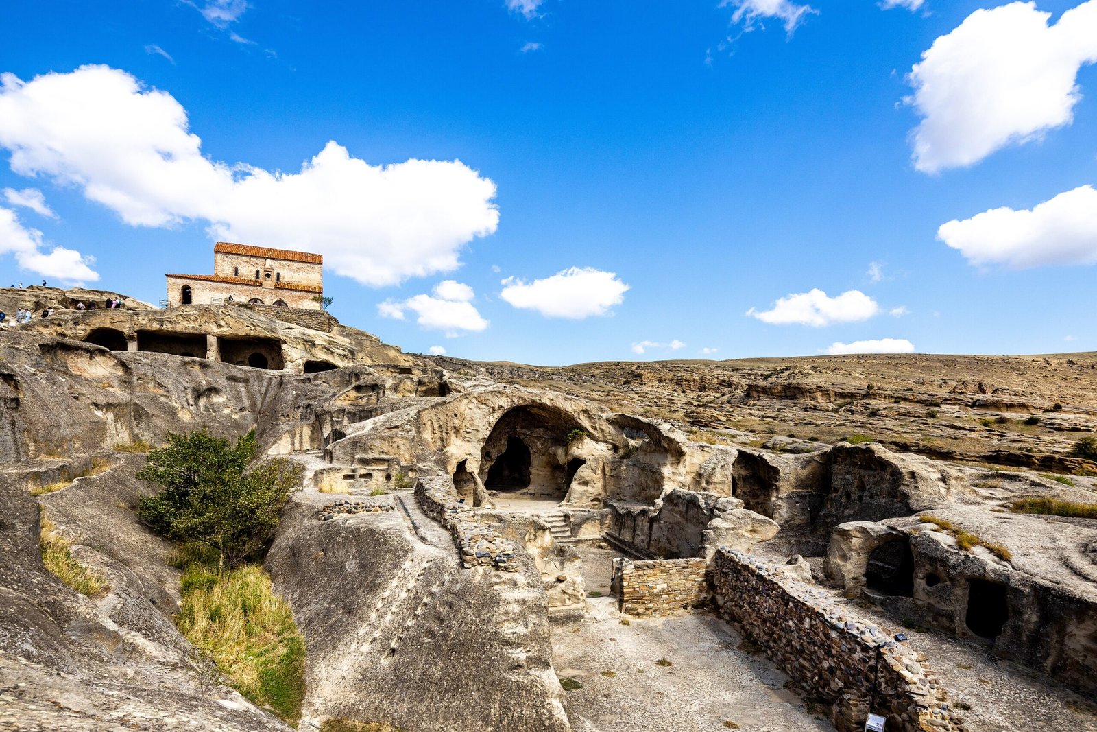
The most dramatic spaces are the large ceremonial halls: the Tamada’s Hall (approximately 12 × 9 metres, with a carved coffered ceiling supported by two columns), the Temple of Makvliani with its elaborate carved facade, and the so-called “wine cellar” — a deep rock-cut pit with a carved trough. Stairs and pathways connect the chambers at multiple levels; some passages are tunnels through the solid rock. The overall effect is of an underground city that has been gradually revealed as centuries of soil and debris were cleared.
At the highest point of the rock sits a small 9th–10th-century Georgian Orthodox basilica — the only freestanding built structure at the site, constructed from stone blocks on a rock-cut platform that previously held pagan temples. The view from the basilica extends across the Mtkvari River valley, with Gori’s hill and castle visible to the west and the Greater Caucasus mountains on the northern horizon. The juxtaposition of the ancient carved city below and the medieval Christian church above captures 2,000 years of Georgian religious history in a single panorama.
Practical information
- Opening hours: Open daily; summer (May–October) approximately 10:00–18:00, winter hours reduced
- Entry fee: Approximately 3–5 GEL (Georgian lari) per adult; combined tickets available with the small on-site museum
- On-site museum: Small museum at the entrance with finds from the excavations; labels in Georgian and English
- Terrain: Steep paths and uneven rock surfaces throughout; sturdy footwear essential; not accessible for mobility-impaired visitors
- Duration: Allow 2–3 hours for a thorough visit
Getting there
Uplistsikhe is approximately 100 km west of Tbilisi. From Gori (served by regular marshrutka minibuses and trains from Tbilisi, journey approximately 1.5 hours), local taxis and marshrutkas connect to the site 10 km to the east; negotiate at the Gori bus/train station. Alternatively, Tbilisi-based tour operators offer day trips combining Uplistsikhe with Gori (Stalin Museum) and sometimes Mtskheta. There is a small car park at the site entrance.
Nearby
- Gori — city 10 km west; Stalin Museum (birthplace of Joseph Stalin) and Gori Fortress
- Mtskheta — UNESCO World Heritage ancient capital of Georgia, 60 km east; Jvari Monastery and Svetitskhoveli Cathedral
- Vardzia — 12th-century cave monastery city carved into a cliff in southern Georgia, approximately 230 km south
- Tbilisi — Georgian capital, approximately 100 km east; Old Town, Narikala Fortress, National Museum
Sources
- Narimanishvili, G. Uplistsikhe: The Rock-Cut City. Georgian National Museum, 2008.
- Javakhishvili, I. History of the Georgian Nation, vol. I. Tbilisi, 1979.
- Wikipedia contributors. “Uplistsikhe.” Wikipedia, The Free Encyclopedia. Accessed 2026.
- UNESCO — “Historic Monuments of Mtskheta” (adjacent WHC context for early Georgian period).
Find it on the map
See this place and what’s around it →📷 Diventa un fotografo di Cultural Heritage Online
Condividi le tue foto dei luoghi: restano pubblicate con la tua firma come autore. Più vengono viste, più ti fai conoscere — e presto un concorso premierà le foto più apprezzate.
Accedi o registrati gratis per aggiungere una foto