

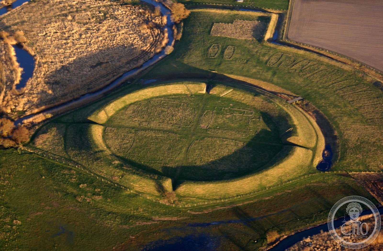
Near Slagelse on the island of Zealand stands a perfectly circular earthen rampart enclosing barracks laid out with a geometric precision rarely seen in Viking-age construction. Built under Harald Bluetooth around 980 AD, Trelleborg housed a professional warrior force and remains the most fully excavated of Denmark’s ring fortresses.
At a glance
Trelleborg stands on a low promontory where the Tude Å and Vårby Å rivers meet, near Slagelse on Zealand. Built around 980 AD under King Harald Bluetooth, who unified Denmark and Norway, it is the most completely excavated of the four surviving Danish Viking ring fortresses. The circular rampart, roughly 136 metres across and six metres high, encloses four quadrants each holding four identical longhouse barracks. Dendrochronological analysis of the timbers points consistently to 980–981 AD, and the fortress appears to have served as a base for the huscarl warriors who replaced the older system of local levies.
Key facts
- Location: Confluence of the Tude Å and Vårby Å rivers, near Slagelse, Zealand, Denmark
- Built: c. 980–981 AD, dated by dendrochronology
- Builder: King Harald Bluetooth (Harald Blåtand, reigned 958–986 AD)
- Rampart: Approximately 136 metres in diameter and 6 metres high
- Longhouses: 16 within the main circle and 15 more in an outer bailey, each around 29.5 by 7.5 metres
- Layout unit: A standard measure of about 29.33 metres, the so-called Viking long rod, used with a deviation of under half a metre around the whole circumference
History
Trelleborg is one of four nearly identical ring fortresses raised across Denmark at roughly the same moment around 980 AD, alongside Aggersborg in northern Jutland, Fyrkat in eastern Jutland, and Nonnebakken beneath modern Odense. Their shared geometry and simultaneous construction point to a single, centrally directed building programme under Harald Bluetooth, undertaken shortly after he had unified Denmark and Norway and overseen the country’s Christianisation.
The fortresses did not last long. After Harald Bluetooth’s death around 986 AD, the huscarl system they were built to support changed, and although occupation continued for some decades, Trelleborg was abandoned by around 1050 AD. The site was first systematically excavated between 1934 and 1942 by the archaeologist Poul Nørlund, whose work uncovered the fortress’s geometric precision and established the dendrochronological dating.
Study of the rampart’s layout shows it was set out using a consistent unit of measurement of about 29.33 metres, with almost no deviation across the full circuit. Achieving this required organised survey methods, including measuring cords, a central stake and angular sighting, a level of technical control more often associated with ecclesiastical or Roman building projects than with Viking-age Scandinavia.
What you see
The earthen rampart of the main ring survives as a substantial earthwork, and visitors can walk its full circumference. The four causeways that once divided the interior into quadrants remain visible as raised paths. Nothing of the timber longhouses stands above ground, but the foundation trenches of the sixteen inner barracks have been marked out on the surface to show their original arrangement. A reconstructed longhouse on site, built to the scale of the originals with bow-shaped walls and a thatched roof, gives a sense of how around fifty warriors might have slept in rows of benches around a central hearth.
The outer bailey, a D-shaped enclosure attached to the main ring and containing fifteen further longhouses, is less striking to look at but is archaeologically important. The adjacent Trelleborg Museum displays finds from the excavations, including iron weapons, silver jewellery and gaming pieces recovered from graves linked to the fortress, offering a glimpse of daily life among the huscarl warriors stationed there a thousand years ago.
Practical information
- Address: Trelleborg Allé 4, 4200 Slagelse, Denmark
- Opening hours and admission: The site operates seasonally; check the Museum Vestsjælland website for current details
- On site: Trelleborg Museum, displaying excavation finds, and a reconstructed longhouse
Getting there
Trelleborg lies a short distance west of Slagelse town centre on the island of Zealand. Slagelse is reachable by train from Copenhagen, and from the station the fortress can be reached by local bus or bicycle. By car, the E20 motorway runs west from Copenhagen towards Slagelse, from where the site is signposted.
Nearby
- Lindholm Høje — a Viking burial ground and settlement near Aalborg, one of Denmark’s largest cemeteries from the period
- Roskilde Cathedral — a UNESCO World Heritage Site and burial place of Danish monarchs, roughly 60 km to the east
- Fyrkat Viking Ring Fortress — a sister fortress in eastern Jutland, sharing the same geometric design
Sources
- Poul Nørlund, Trelleborg (Gyldendal, 1948)
- Olaf Olsen & Holger Schmidt, Fyrkat: En jysk vikingeborg (Nationalmuseet, 1977)
- Else Roesdahl, The Vikings (Allen Lane, 1987)
- Wikipedia: Trelleborg (Denmark)
- Museum Vestsjælland
Find it on the map
See this place and what’s around it →📷 Become a Cultural Heritage Online photographer
Share your photos of places: they stay published under your name as the author. The more they're seen, the more you get noticed — and soon a contest will reward the most appreciated photos.
Log in or sign up free to add a photo