Stonehenge, Avebury and Associated Sites
The most important prehistoric landscape in Europe and the defining symbol of Neolithic Britain — Stonehenge and Avebury, 40 kilometres apart on the chalk plains of Wiltshire, represent the most ambitious stone construction projects of the prehistoric Atlantic world, built and rebuilt over 1,500 years by communities whose names, language, and beliefs have left no written record.
At a glance
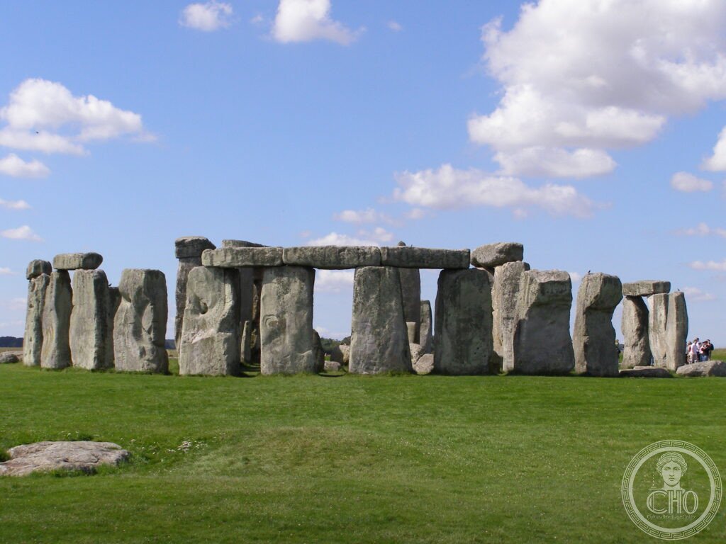
Stonehenge, Avebury and Associated Sites (UNESCO WHS 1986; the World Heritage Site encompasses not just Stonehenge and Avebury but the entire prehistoric landscape of Wiltshire including Silbury Hill, West Kennet Long Barrow, The Sanctuary, and approximately 350 burial mounds (round barrows) within the World Heritage Area of approximately 2,600 ha); the construction timeline (the most important fact about Stonehenge: it was not built in a single period by a single culture; it was a construction project that extended over approximately 1,500 years through at least three distinct phases): Phase 1 (c.3000–2920 BCE; the earliest Stonehenge; the circular bank and ditch enclosure (approximately 100 m in diameter; approximately 2 m deep × 6 m wide) with the 56 Aubrey Holes (the ring of 56 pits just inside the bank; the pits were filled with cremated human remains — the most important prehistoric cremation cemetery in Britain; at least 63 individuals were buried here); Phase 2 (c.2900–2400 BCE; the monument was used primarily as a cremation cemetery; no visible standing stones; the most funerary of all the Stonehenge phases); Phase 3a (c.2600–2400 BCE; the most transformative period; the arrival of the first standing stones: the bluestones (the 82 smaller stones; each weighing 2–5 tonnes; quarried from the Preseli Hills of south-west Wales 250 km away — the most ambitious stone transport project in Neolithic Britain)); Phase 3b (c.2500–2400 BCE; the arrival of the sarsen stones (the large sandstone blocks from Marlborough Downs 25 km north; each weighing 15–50 tonnes; the most important engineering achievement of Neolithic Britain — raising 50-tonne stones and placing 7-tonne lintels on top of them using only wooden sledges, ropes, and human muscle power)); Phases 3c–3f (c.2400–1600 BCE; multiple rearrangements of the bluestones; the final Stonehenge plan).
Key facts
- The sarsen stones: the engineering achievement of the Neolithic age — the sarsen stones (a form of silcrete — a naturally occurring sedimentary rock composed of silica-cemented sand grains; extremely hard and weather-resistant; the specific type at Stonehenge is West Woods sarsen (from a source at West Woods, 25 km north of Stonehenge in the Marlborough Downs; the geological match confirmed by a 2019 geochemical analysis using portable X-ray fluorescence); the dimensions of the outer circle uprights (each approximately 4.1 m above ground + 1.5 m below ground = 5.6 m total height; 2.1 m wide; 1.1 m thick; weight approximately 25 tonnes); the dressing (the stones were dressed (shaped) using sarsen hammerstones (rounded pieces of sarsen weighing up to 25 kg that were pounded against the upright surfaces to create a smoother finish); the estimated volume of material removed (1.2 tonnes per stone × 30 stones = 36 tonnes of stone debris (the most industrious stone-dressing project in prehistoric Britain)); the transport (the sarsens were transported on wooden sledges drawn by human and perhaps animal muscle over 25 km of chalk downland (the most carefully documented prehistoric transport project in Britain; experimental archaeology (the Marlborough to Stonehenge Project) has demonstrated that a 25-tonne sarsen can be moved by 200 people over chalk downland at approximately 1 km per day))
- The bluestones: the mystery of the 250-km journey — the bluestones (the 82 smaller stones; mostly spotted dolerite and rhyolite from the Preseli Hills (Mynydd Preseli) of Pembrokeshire, south-west Wales; the transport distance (the most disputed question in Stonehenge archaeology: 250 km as the crow flies, but the actual route is unknown; the two main theories: the sea route (around the south-west coast of Wales to the Bristol Avon; the most popular theory; requires loading 2–5 tonne stones onto wooden rafts or dugout canoes — the most demanding marine transport in Neolithic Britain); the land route (across the Brecon Beacons and along the river valleys of south Wales; the most recent experimental archaeology has suggested the land route is more feasible than previously thought; the glacier hypothesis (the 19th-century hypothesis that the bluestones were transported to Wiltshire by the glaciers of the last Ice Age; definitively rejected by the geological evidence — the Pleistocene ice sheets did not reach Wiltshire)); the precision of the quarry identification (a 2015 study by Parker Pearson et al. identified the specific quarries in the Preseli Hills from which the bluestones were taken (Carn Goedog for the spotted dolerite; Rhosyfelin for the rhyolite); the discovery of matching stone chips at both Stonehenge and the quarries is the most precise provenance evidence in prehistoric British archaeology))
- Avebury: the largest stone circle in the world — Avebury (the key statistics: the outer bank and ditch (approximately 1.3 km in circumference; the bank originally approximately 17 m high; the ditch approximately 9 m deep — the most physically impressive earthwork in prehistoric Britain after the chalk figure of the Long Man of Wilmington; the three stone circles: the outer stone circle (originally approximately 100 stones; 331 m in diameter; the largest prehistoric stone circle in the world (in physical diameter; compared to Stonehenge (108 m), the Ring of Brodgar (104 m), and Callanish (43 m)); the northern inner circle (approximately 98 m diameter; originally approximately 27 stones; the Cove at the centre (3 massive stones arranged in a U-shape; the most impressive individual stone grouping at Avebury)); the southern inner circle (approximately 108 m diameter; the Obelisk (now fallen and no longer visible above ground; it was the tallest single stone in prehistoric Britain when standing)); Silbury Hill (the largest prehistoric artificial mound in Europe; 40 m high; 167 m in diameter at the base; approximately 248,000 m³ of chalk and clay; constructed c.2400–2300 BCE; 4+ million man-hours of labour (the most demanding prehistoric earthwork construction project in Britain); the purpose: entirely unknown (the most important unsolved question in British prehistoric archaeology; excavations in 1776, 1849, 1968–70, and 2000 found no central burial or offering; the most elaborate archaeological puzzle in Wiltshire))
- The astronomical alignments: what Stonehenge was (possibly) for — the solstice alignment (the most important single fact about Stonehenge geometry: the axis of the monument is aligned with the summer solstice sunrise (the Heel Stone and the main NE–SW axis of the monument are oriented so that on the summer solstice (21 June), the sun rises within a few degrees of the Heel Stone as viewed from the centre; the winter solstice sunset alignment (looking from the NE entrance back through the monument toward the SW, the winter solstice sun sets through the central trilithon gap — the most important astronomical alignment in the monument (some archaeologists argue the winter solstice was the primary alignment since the main avenue approaches from the NE and the central stone settings frame the SW (winter sunset) more precisely than the NE (summer sunrise))); the lunar alignments (the 56 Aubrey Holes may represent a Metonic-like lunar calendar (the most debated astronomical hypothesis in Stonehenge archaeology; Hawkins (1965) proposed that the 56 holes could be used to predict lunar eclipses; the proposal has been debated for 60 years without resolution))
- Heritage: UNESCO World Heritage Site, Stonehenge, Avebury and Associated Sites, inscribed 1986
- GPS: 51.1789° N, -1.8262° E (Stonehenge)
History
The Neolithic beginning (c.4000–3000 BCE; the Neolithic communities of the Wiltshire chalkland built the first monuments — the causewayed enclosures (Windmill Hill, 3.5 km from Avebury; c.3650 BCE; the most important causewayed enclosure near the Avebury complex) and the long barrows (West Kennet Long Barrow; c.3650 BCE; 100 m long; the burial chamber (6 sarsen-walled chambers; approximately 46 individuals interred over 1,000 years; the most important megalithic tomb in Wiltshire))); the construction of Stonehenge (c.3000–1500 BCE; the three main phases as described above); the Bronze Age (c.2400–800 BCE; the period when the surrounding landscape filled with round barrows — approximately 350 burial mounds visible in the World Heritage Area; the most important Bronze Age cemetery complex in Britain; the people buried in these mounds (the Beaker people (named for the distinctive ceramic drinking vessels placed in their graves; the most important cultural introduction to Britain in the Early Bronze Age; recent ancient DNA studies have demonstrated that the arrival of the Beaker people (c.2500 BCE) coincided with a near-total replacement of the existing Neolithic population of Britain by new migrants from continental Europe — the most dramatic population change in British prehistoric history)); the Roman period (Roman roads avoided Stonehenge; the monument was apparently treated with respect or fear; Roman artefacts have been found in excavations at Stonehenge but no Roman construction or destruction); the medieval vandalism (some stones were pulled down and/or buried during the medieval period; the reasons are unknown; the most important modern archaeology: the re-erection of fallen stones (several stones were re-erected in the 20th century; the most controversial: the erection of the fallen Slaughter Stone in 1901 (which was repositioned in a vertical position and then found to have been horizontal; the mistake was not corrected))); UNESCO WHS 1986.
What you see
Stonehenge today (the visitor experience has been significantly improved since the opening of the new visitor centre in 2013 (the Stonehenge visitor centre; designed by Denton Corker Marshall; 2.7 km from the monument; the most important improvement: the closure of the A344 road (the road ran within 30 m of the monument and was closed in 2013; the most important single change to the Stonehenge landscape in the 20th century; the return of the road surface to grassland has restored the prehistoric landscape setting that was lost in 1873 when the road was built); the approach (visitors arrive at the visitor centre, pass through the exhibition (the most important object: a display of the actual sarsen stone chips recovered from the excavations — the best opportunity to understand the scale and texture of the individual stones without crossing the fence), then take a shuttle or walk the 2.7 km to the monument); the stone circle access (the stones are fenced; standard tickets give walking access around the fence at a distance of approximately 10 m; the special access visits (the only legal way to enter the stone circle itself: the inner-circle access visits (pre-bookable; limited to 30 people per slot; available in early morning and late evening outside opening hours; the most intimate Stonehenge experience; the stones can be touched (a unique experience — the texture of the sarsen surface, pitted from weathering and the sarsen-hammerstone dressing, is unexpectedly rough))); the solstice (the winter solstice (21 December) and summer solstice (21 June) are the only two occasions when free public access to the stone circle is granted; the summer solstice sunrise draws approximately 10,000–20,000 people (the most attended single-site event in British prehistory; the experience ranges from transcendent (if cloudy) to overwhelming (if clear and packed)).
Practical information
- Getting there: by train to Salisbury from London Waterloo (1h 30min; the most direct rail option); then the dedicated Stonehenge Tour Bus from Salisbury (seasonal; approximately 30 min; GBP 17.50 return (includes admission to Old Sarum castle; the most economical combined approach)); by car (the A303 (the most important road for Stonehenge access (and the road at the centre of the most politically charged infrastructure debate in recent British history: the proposed A303 tunnel (to move the road underground and restore the prehistoric landscape; approved 2021; then rejected by the UK Supreme Court (2023) on planning grounds; then re-approved (2024); as of 2026 the tunnel is under construction/planned and will be the most expensive single heritage infrastructure investment in British history (approximately GBP 1.7 billion)); 2h from London; the car park (the A344-side car park is closed; parking is now at the visitor centre (Airman’s Corner)); by bicycle (the Sustrans Route 45 (the national cycle route) passes within 2 km of Stonehenge; the most eco-friendly approach; the most athletic approach))
- Avebury vs. Stonehenge: which to visit first — the case for Avebury (the single strongest argument: you can walk among the stones; the village of Avebury is built inside the outer stone circle (the most remarkable cohabitation of a living village with a prehistoric monument anywhere in the world; the Avebury Manor is inside the stone circle; the Red Lion pub is inside the stone circle; the most unusual pub setting in England); the Avebury entrance is free (the stones are accessible without any ticket; unlike Stonehenge which requires a ticket and provides only external viewing on standard visits; the most important practical argument for Avebury-first)); the case for Stonehenge (the single strongest argument: it is more famous and the international visitor expectation of “England’s most important prehistoric monument” is fulfilled here; the framing photography (the trilithons against the Wiltshire sky; no other monument in England provides the same silhouette))
- The Wiltshire heritage circuit: 3 days from Bath — Day 1 (Bath; the Roman Baths (the most important Roman remains in Britain; the sacred spring of Sulis Minerva; 1.5 million litres of water per day; the most complete Roman bath complex in northern Europe); the Georgian City (Bath is a UNESCO WHS (1987) for its Georgian urban architecture; the Royal Crescent (the finest Georgian crescent in Britain; designed by John Wood the Younger (1767–1774); 30 houses in a single continuous facade of 30 Ionic columns stretching 157 m (the most geometrically ambitious Georgian elevation in Britain)); Day 2 (Stonehenge + Old Sarum (the original fortified site of Salisbury; 5 km north of the city; the Iron Age hillfort that became a Norman castle and the original Salisbury Cathedral before the city was moved to the valley in 1220; the most important abandoned city site in Wiltshire); Salisbury Cathedral (the tallest cathedral spire in Britain at 123 m; the most perfectly preserved medieval cathedral interior in England; home to the best-preserved of the four surviving copies of Magna Carta (1215; the most important constitutional document in English legal history))); Day 3 (Avebury + Silbury Hill + West Kennet Long Barrow))
Getting there
Train: London Waterloo → Salisbury 1h30, then Stonehenge Tour Bus (seasonal; GBP 17.50 return). By car: A303 from London (2h). Inner circle special access pre-bookable. GPS Stonehenge: 51.1789, -1.8262. GPS Avebury: 51.4286, -1.8542.
Nearby
- Salisbury Cathedral and Magna Carta — 15 km south of Stonehenge (20 min by car; 45 min by Stonehenge Tour Bus); the finest Early English Gothic cathedral and home to the most legible surviving copy of Magna Carta — Salisbury Cathedral (the most uniformly Gothic cathedral in England (built in a single phase between 1220 and 1320 CE; unlike most medieval cathedrals which accumulated different styles over centuries, Salisbury was built in 100 years in a single Early English Gothic style — the most architecturally coherent cathedral in England); the spire (123 m; the tallest cathedral spire in Britain; built 1320; began to lean almost immediately (the foundations were not adequate for the weight; the architect of the spire apparently knew this; the medieval engineering solution (iron clamps and bracing added in the 14th and 15th centuries)); the Magna Carta (the Salisbury copy; one of 4 surviving originals from 1215; the Chapter House copy at Salisbury is the best preserved of the four; the only one that has never been repaired or restored; the most important constitutional document in the English legal tradition))
- Bath (UNESCO WHS 1987) — 50 km north-west of Stonehenge (1h by car); the finest Roman and Georgian heritage in Britain in a single city — the Roman Baths (the most important Roman remains in Britain; the natural hot spring (Aquae Sulis; the sacred spring of the goddess Sulis Minerva; 1.5 million litres of 46°C water per day; the most impressive surviving Roman hydraulic engineering in Britain); the gilded bronze head of Minerva (the most important Roman metalwork find in Britain; the face that looks out from the Roman Baths posters; the eyes (the ancient glass inlay is gone but the expression of detached divinity is perfectly legible at 1,900 years distance)); the Georgian City (the Royal Crescent; the Circus (the other Wood masterpiece; 30 houses arranged in a perfect circle around a central lawn; the plane trees in the central lawn were planted in 1800 and are now the most important single stand of trees in Bath); the Thermae Bath Spa (the only working thermal spa in Britain; the rooftop pool overlooking the Georgian roofscape is the finest urban bathing experience in the UK))
- The Jurassic Coast (UNESCO WHS 2001) — 60 km south of Stonehenge (1h by car to the coast at Bournemouth or Swanage); the finest coastal geology in Europe and the most important fossil site in Britain — the Jurassic Coast (the 154 km of coastline from Orcombe Point (Devon) to Studland Bay (Dorset); UNESCO WHS 2001 (the first natural WHS in England; the most important geological site in the British Isles); the cliff succession (the cliffs expose 185 million years of geological history from the Triassic (the oldest, at the Devon end) through the Jurassic to the Cretaceous (the youngest, at the Dorset end) — the most complete stratigraphic section of this period in any coastal exposure in the world); Lyme Regis (the fossil capital of Britain; the Blue Lias cliffs (the most productive fossil site in the Jurassic Coast; Mary Anning (1799–1847; the most important fossil collector in British history; the person who found the first complete Ichthyosaurus skeleton (1811) and the first Plesiosaurus skeleton (1823) and the first Pterodactylus skeleton found outside Germany (1828) — the most remarkable series of palaeontological discoveries by a single person in any country); Durdle Door (the most famous single geological feature of the Jurassic Coast; a natural limestone arch in the sea; the most photographed coastal geology in England))
Sources
- Wikipedia, Stonehenge; Avebury; Silbury Hill; West Kennet long barrow, accessed June 2026
- UNESCO, Stonehenge, Avebury and Associated Sites, WHS reference 373bis, inscribed 1986
- Mike Parker Pearson, Stonehenge: Exploring the Greatest Stone Age Mystery, Simon & Schuster, 2012
Find it on the map
See this place and what’s around it →📷 Diventa un fotografo di Cultural Heritage Online
Condividi le tue foto dei luoghi: restano pubblicate con la tua firma come autore. Più vengono viste, più ti fai conoscere — e presto un concorso premierà le foto più apprezzate.
Accedi o registrati gratis per aggiungere una fotoDo you manage this place?
This page is read by travellers and heritage enthusiasts who find it on Google. Keep it accurate — and make it work for you. Free for non-profit heritage institutions.