Sian Ka’an (sito naturale): la riserva della biosfera Maya sulle coste dei Caraibi
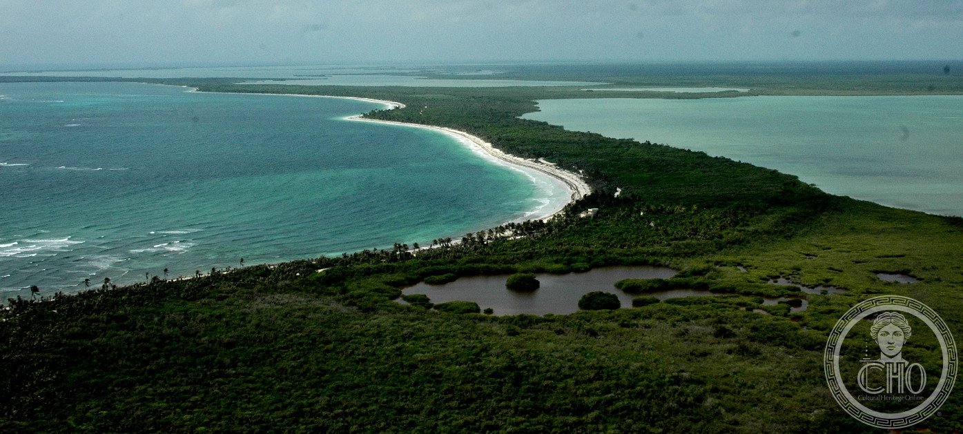
A pochi chilometri a sud di Tulum, la Riserva della Biosfera Sian Ka’an — nome che in lingua Maya significa “dove il cielo nasce” — si estende per 528.000 ettari lungo la costa caraibica del Messico. Una mosaic di barriera corallina, lagune, mangrovie, foresta tropicale e zone umide, punteggiata di siti archeologici Maya e attraversata da canali che i Maya usavano per commerciare tra le città dell’entroterra e i porti marini. Patrimonio UNESCO dal 1987, è uno degli ecosistemi costieri più intatti del Mesoamerica.
At a glance
Sian Ka’an Biosphere Reserve covers 528,000 hectares on the Caribbean coast of Quintana Roo, Mexico, south of Tulum. It encompasses tropical forest, mangroves, freshwater lagoons, saltwater bays, and the second-longest barrier reef in the world (the Mesoamerican Reef). Over 300 bird species, 350 fish species, manatees, jaguar, tapir, sea turtles and crocodiles inhabit the reserve. The area contains some 23 known Maya archaeological sites, including Chunyaxché (Muyil), connected to the coast by Maya-built canals still used for boat tours. UNESCO inscribed Sian Ka’an in 1987.
Key facts
- UNESCO: World Heritage since 1987 (Sian Ka’an Biosphere Reserve, ref. 410)
- Area: 528,000 hectares including land and marine environments
- Reef: part of the Mesoamerican Reef — the world’s second-longest barrier reef
- Maya sites: 23 known archaeological sites including Muyil (Chunyaxché) with Maya canals
- Key species: jaguar, tapir, American crocodile, West Indian manatee, hawksbill and loggerhead sea turtles
- Name: “Sian Ka’an” means “where the sky is born” in Mayan
History
The Sian Ka’an coast has been inhabited since at least 300 BC. During the Maya Classic and Post-Classic periods (300–1521 AD), the coastal lagoons were the main highways connecting Maya cities to the sea: merchants paddled canoes through mangrove channels and inland lagoons, trading jade, obsidian, cacao and salt. The site of Muyil (Chunyaxché), at the northern edge of what is now the biosphere reserve, was an active Maya port linked by canal to the Laguna de Chunyaxché. Maya canoe channels can still be floated today.
After the Spanish conquest, the coast was largely abandoned as disease and warfare decimated the Maya population. The dense jungle recovered quickly and the area remained virtually unpopulated through the colonial period. The modern biosphere reserve was declared by Mexico in 1986 and inscribed by UNESCO in 1987, just as mass tourism was beginning to transform the Riviera Maya to the north. The reserve has since buffered the corridor between Tulum and the south from development, though illegal settlement and fishing remain challenges.
What you see
Sian Ka’an offers experiences impossible anywhere else on the Riviera Maya: floating silently through Maya canals surrounded by mangroves and white herons; snorkelling in azure lagoons connected to the reef; watching sea turtles nest on remote beaches (May–October); spotting manatees in the bays. The Muyil ruins are accessible by road from the reserve entrance, with a short trail to a Maya watchtower with views over the lagoon.
Tour operators in Tulum run day trips into the reserve via boat — the most popular being the Maya canal float from Muyil lagoon to the sea. Overnight camping and kayaking permits are available through Amigos de Sian Ka’an (the local NGO partner).
Practical information
- Base: Tulum town or Tulum beach, 15 km north; Cancún is 130 km north (with international airport)
- Access: the reserve entrance is 9 km south of Tulum ruins on the coastal road (Mex 307 then coastal road)
- Tours: day tours from Tulum include the Maya canal float and snorkelling; book through Amigos de Sian Ka’an
- Best time: November–April (dry season, fewer mosquitoes); sea turtles nesting June–October
Getting there
Drive south from Tulum on the coastal road (not Highway 307) along the Caribbean coast; the reserve entrance is 15–20 km south of Tulum ruins. Alternatively, take a tour from Tulum. The nearest international airport is Cancún (CUN), 130 km north. GPS: 19.38° N, 87.79° W.
Nearby
- Tulum (UNESCO) — the cliff-top Maya ruins overlooking the Caribbean, 15 km north
- Cobá — a large Maya city with a climbable pyramid in the jungle, 45 km north-west
- Banco Chinchorro — Mexico’s largest atoll reef, 160 km south — world-class diving and snorkelling
Sources
- UNESCO World Heritage Centre — “Sian Ka’an Biosphere Reserve” (ref. 410)
- Encyclopaedia Britannica — Sian Ka’an
- Amigos de Sian Ka’an — reserve management and tours
Find it on the map
See this place and what’s around it →📷 Diventa un fotografo di Cultural Heritage Online
Condividi le tue foto dei luoghi: restano pubblicate con la tua firma come autore. Più vengono viste, più ti fai conoscere — e presto un concorso premierà le foto più apprezzate.
Accedi o registrati gratis per aggiungere una foto