Shushtar Historical Hydraulic System
One of the most ambitious hydraulic engineering projects of antiquity — an Achaemenid-era irrigation system expanded under the Sassanids using Roman prisoners of war, still partially operational after 2,500 years, and inscribed as a UNESCO World Heritage Site in 2009.
At a Glance
The Shushtar Historical Hydraulic System in Khuzestan Province, southwestern Iran, represents a masterpiece of ancient water engineering on the Karun River. Begun during the Achaemenid period (c. 5th–4th century BCE) and dramatically expanded under the Sassanid dynasty (3rd–7th century CE), the system channelled, stored, and distributed the waters of the Karun across the fertile Mianab plain using a network of dams, tunnels, canals, waterfalls, and underground aqueducts. The engineering feat created spectacular 60-metre-wide waterfalls, powered over 40 water mills, and sustained agriculture across one of the most productive plains of ancient Persia for over fifteen centuries.
Key Facts
- UNESCO inscription: 2009, World Heritage Site #1315
- Location: Shushtar city, Khuzestan Province, southwestern Iran
- Period: c. 5th century BCE (Achaemenid) through 7th century CE (Sassanid) and beyond
- Key structure: Band-e Kaisar (Caesar Dam), built c. 260 CE with Roman prisoner labour
- Waterfalls: Shushtar Falls — approximately 60 metres wide, still flowing
- Water mills: Over 40 original mills for grain and olive oil production
- Main canals: Gargar and Shoteit diversion channels from the Karun River
- Operational status: Parts of the system remain in use for irrigation today
History
The foundations of the system date to the Achaemenid Empire, when engineers first diverted and controlled the flow of the Karun River through a network of channels to irrigate the Mianab plain between the rivers Gargar and Shoteit. The region around ancient Susa (modern Shush) was one of the administrative and economic heartlands of the Persian Empire, and its agricultural productivity depended on systematic water management.
The most historically dramatic episode occurred in 260 CE, when the Sassanid king Shapur I defeated and captured the Roman Emperor Valerian at the Battle of Edessa — the only Roman emperor ever taken prisoner in battle. Among the tens of thousands of Roman prisoners Shapur brought east were military engineers, who were set to work constructing the Band-e Kaisar (Band-i-Kaisar, meaning Caesar Dam or Dam of Caesar). The dam-bridge across the Karun incorporated Roman engineering techniques alongside Persian hydraulic expertise, demonstrating an extraordinary transfer of technical knowledge across enemy lines. The bridge section of the structure carried the royal road over the Karun River simultaneously with its function as a weir.
The Sassanid engineers used the dam to force water into the Gargar Canal, which fed the Shoteit Canal and a network of underground tunnels (qanats) and mill channels. By the height of the Sassanid period (5th–6th century CE) the system was irrigating the entire Mianab plain and producing sufficient grain and olive oil through its water-powered mills to sustain a major urban centre.
Arab conquest in the 7th century CE brought administrative changes but left the hydraulic system substantially intact. It continued to function under various Islamic dynasties and remained operational in significant part through the 20th century. Today portions of the Gargar Canal still carry water for irrigation, and the Shushtar Falls — the spectacular outlet created where the diversion canals rejoin the main Karun — continue to flow as a dramatic natural monument to ancient engineering.
What You See
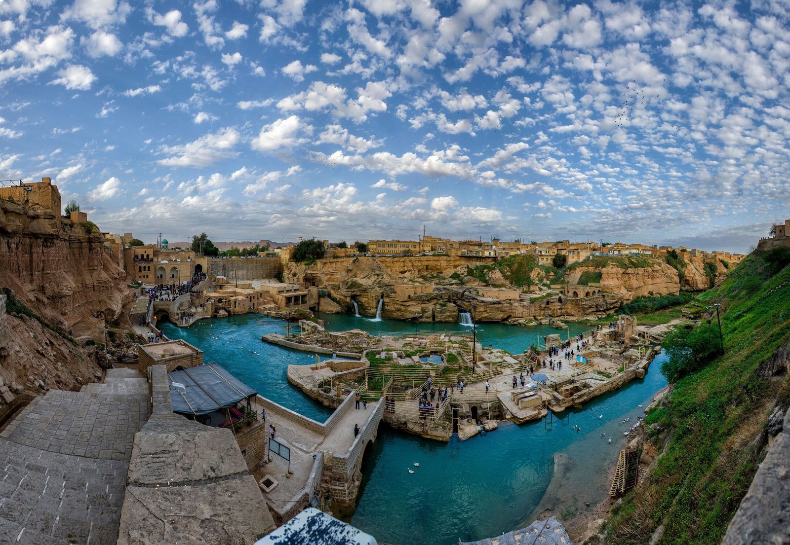
The Band-e Kaisar today survives as a substantial masonry structure crossing the Karun River; portions of the bridge piers remain standing in the water, and the full extent of the dam-bridge can be appreciated from the riverbank. The Shushtar Falls — where water released from the Gargar and Shoteit canals returns to the Karun level — create a wide curtain of cascading water approximately 60 metres across, one of the most visually striking ancient engineering monuments in Iran. The surrounding rock-cut infrastructure includes the entrances to mill channels carved directly into the limestone riverbank, some still showing the slots and housings for water-wheel machinery.
The old city of Shushtar preserves remains of the Sassanid-era bridge-dam, the canal headworks, and the historic neighbourhood of Salasil (Salasel Castle), which overlooks the entire hydraulic system from a rocky promontory. The UNESCO-designated zone encompasses the principal hydraulic features distributed across several kilometres of the Karun Valley.
Practical Information
- Open: The falls and canal areas are accessible most of the day; Salasel Castle has site-specific hours
- Entry: Nominal entrance fees apply to enclosed monument areas
- Best time: Spring and early autumn for optimal water flow at the falls and pleasant temperatures
- Time needed: Half day to walk the principal sites along the Karun
- Photography: Permitted; dawn and late afternoon light best for the falls
Getting There
Shushtar is located in Khuzestan Province, approximately 90 km north of Ahvaz, the provincial capital. Ahvaz has an international airport (AWZ) with connections to Tehran and other major Iranian cities. From Ahvaz, shared taxis and buses run regularly to Shushtar (approximately 2 hours). The site is not served by rail directly; Ahvaz is the nearest major rail hub.
Nearby
- Susa (Shush) — 45 km southwest: ancient Elamite and Achaemenid capital, UNESCO World Heritage Site; home to the Palace of Darius and the tomb of the Prophet Daniel
- Chogha Zanbil Ziggurat — 80 km south: 13th century BCE Elamite ziggurat, among the best-preserved in the world, UNESCO WHS
- Ahvaz — 90 km south: regional capital with Karun River promenade and the Ahvaz Suspension Bridge
Sources
- UNESCO World Heritage List: Shushtar Historical Hydraulic System, Property #1315 (2009)
- Potts, D.T. The Archaeology of Elam. Cambridge University Press, 1999.
- Wikipedia: “Shushtar Historical Hydraulic System”. Retrieved June 2026.
Find it on the map
See this place and what’s around it →📷 Diventa un fotografo di Cultural Heritage Online
Condividi le tue foto dei luoghi: restano pubblicate con la tua firma come autore. Più vengono viste, più ti fai conoscere — e presto un concorso premierà le foto più apprezzate.
Accedi o registrati gratis per aggiungere una foto