Scicli
Scicli (UNESCO 2002, uno degli 8 comuni del Val di Noto tardo-barocco) è il centro meno visitato e più autentico della serie — ricostruita dopo il devastante terremoto del 1693 CE su un piano urbanistico borbonico a griglia regolare, conserva il nucleo barocco siciliano più intatto del Val di Noto, e ha guadagnato fama internazionale come set del commissario Montalbano (il commissariato di Vigata è il Municipio di Scicli in Via Francesco Mormino Penna).
At a glance
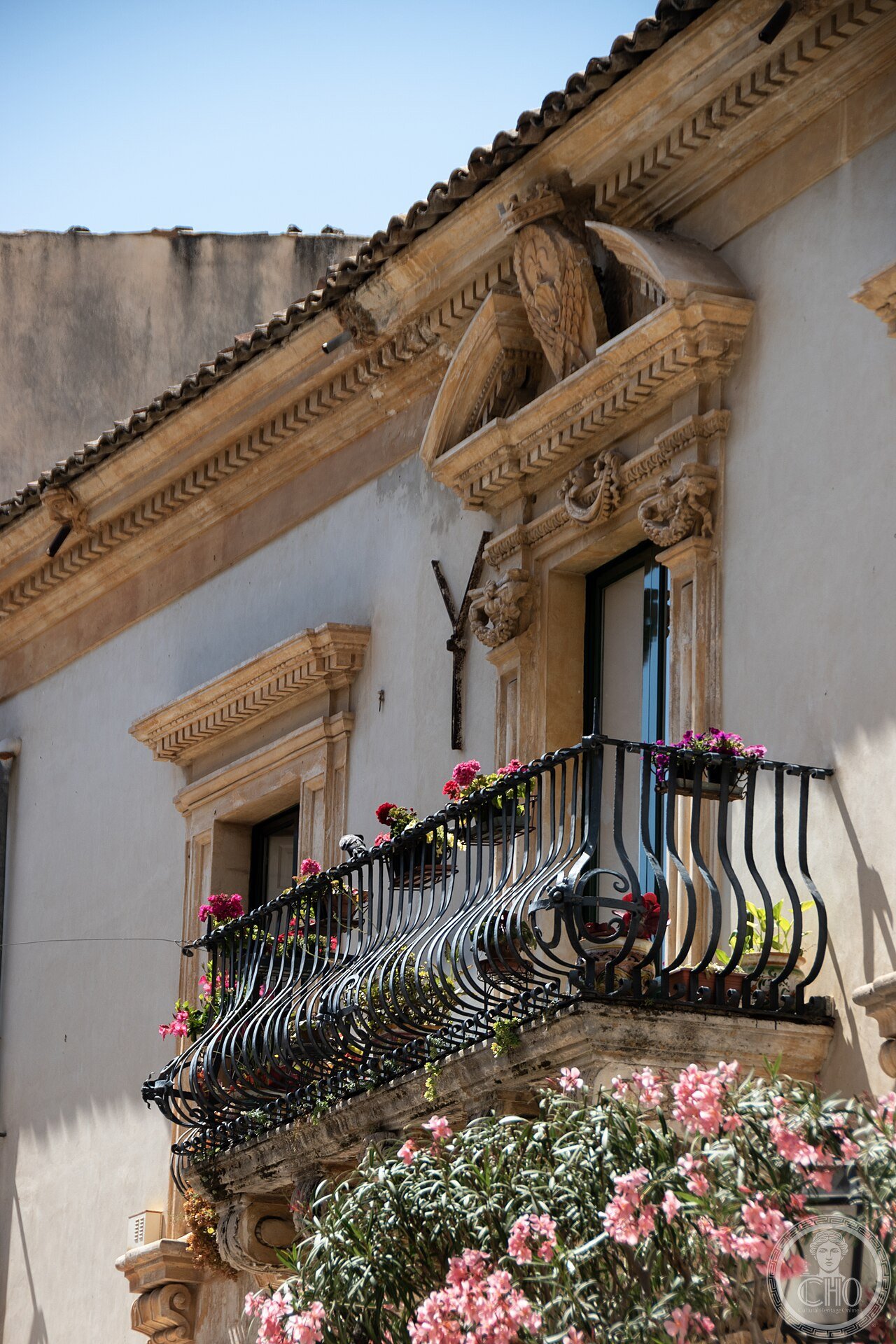
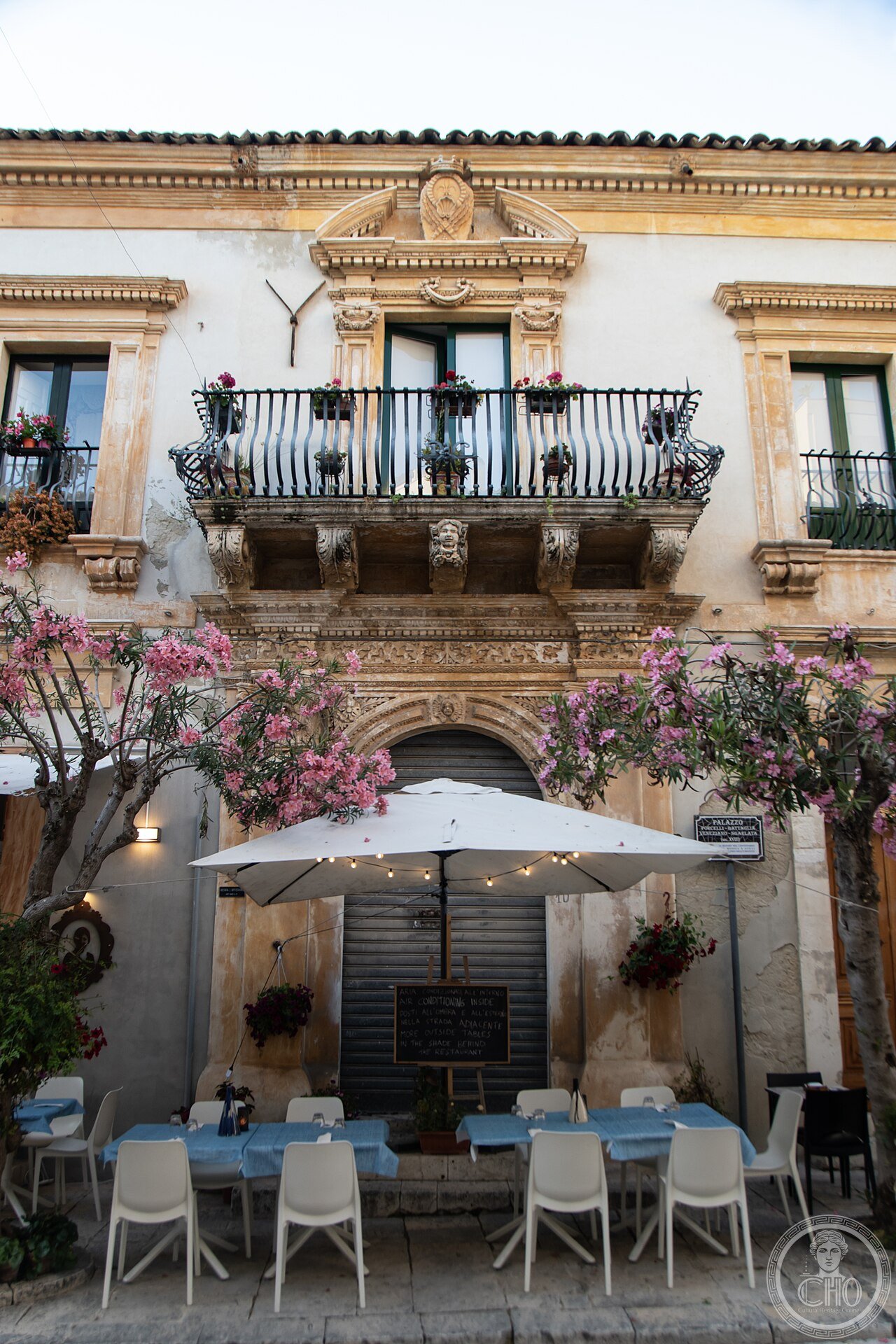
Scicli Val di Noto (the most precisely Scicli zone Scicli Sicilia Italy 36.7930 N 14.7050 E UNESCO WHS 2002 reference 1024: the Val di Noto serial site (8 municipalities: Caltagirone, Militello in Val di Catania, Catania, Modica, Noto, Palazzolo Acreide, Ragusa, Scicli; the inscription covers the entire rebuilt urban fabric of each city: 500+ baroque buildings across the 8 towns); the 1693 earthquake (the Sicily earthquake of January 11, 1693 CE: (1) the date and time: Saturday, 11 January 1693 CE at 21:00 local time (the earthquake struck at night when the population was indoors); (2) the magnitude: estimated 7.4 on the moment magnitude scale (the largest earthquake in Italian recorded history); (3) the affected area: eastern Sicily (Val di Noto) — the epicenter was in the Ionian Sea, 20 km from the coast between Augusta and Catania; (4) the deaths: 60,000 total in eastern Sicily; 11,000 in the Val di Noto area; the specific cities (Noto vecchia: 6,000 dead of 12,000 inhabitants (50% mortality); Ragusa: 5,000 dead; Catania: 16,000 dead; Scicli: 1,600 dead of 8,000 inhabitants)); the Scicli reconstruction (1693–1750 CE: the Scicli reconstruction was the most radical of the 8 Val di Noto towns because Scicli had the flattest available terrain (the valley floor between 3 limestone hills): the new town plan (the “Regolamento” of Pedro Ramón de Rubì, 1693 CE): the straight-grid plan; the main axis (Via Francesco Mormino Penna: 600 m long; the widest street at 12 m; the processional space for festivals and market): the specific baroque character of the Scicli reconstruction (the Scicli baroque style is the most extreme of the 8 towns: the church facades are concave-convex alternating planes; the palazzo gates have stone mascheroni (grotesque face keystones) of extreme elaboration; the Palazzo Beneventano dell’Aquila (c.1770 CE; Via Mormino Penna): the 9 mascheroni above the window keystones (the faces: a Moor, a Satyr, an old man with open mouth, a Fool, a young woman with elaborate coiffure; each face is different and detailed to the level of individual hair strands))).
Key facts
- Scicli come set del commissario Montalbano e come questo ha trasformato il turismo siciliano: the Montalbano effect (the “Inspector Montalbano” TV series (RAI Uno; Italian; based on Andrea Camilleri’s novels set in the fictional town of “Vigàta”; the production company used Scicli as the location for the “Commissariato di Vigàta” (the police headquarters): the building is the historic Municipio (town hall) of Scicli in Via Francesco Mormino Penna; the series ran from 1999 CE to 2021 CE (22 episodes + 26 films of 100 min each; total: 48 productions); the specific visitor impact (the pre-Montalbano visitor count for Scicli (1990s CE): approximately 5,000 visitors per year; the 2018 CE count: 180,000 visitors (a 36× increase); the specific pilgrimage (the tour of the “Luoghi di Montalbano” is now a defined tourist itinerary marked with specific signs throughout Scicli, Ragusa Ibla, Modica, Punta Secca (the village of Marinella where Montalbano lives), and Porto Empedocle (Camilleri’s hometown))); the Vigàta geography (the TV geography of Vigàta is internally consistent but spreads across 4 provinces: Montalbano’s house (Punta Secca, Ragusa province); his office (Scicli, Ragusa province); his regular restaurant (a fictitious combination using multiple real restaurants in Punta Secca and Modica); the beach scenes (Cefalù and Donnalucata); the UNESCO-noted towns appear in the background consistently))
- GPS (Palazzo Beneventano, Via Mormino Penna): 36.7930° N, 14.7050° E
History
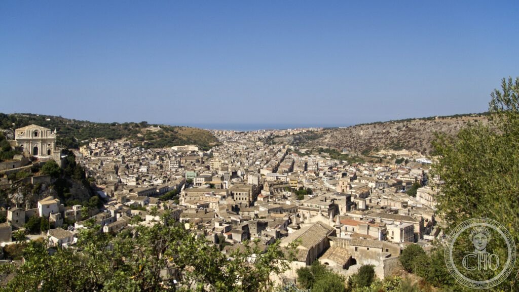
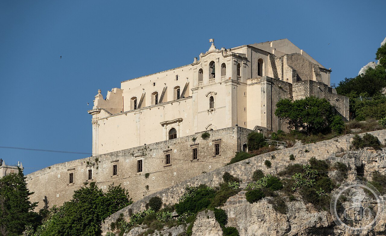
Dal terremoto 1693 CE alla ricostruzione barocca all’UNESCO 2002 (the most precisely Scicli zone history: the pre-earthquake Scicli (the medieval Scicli was built on the 3 limestone hills (San Matteo, Junchi, Croce) above the current city; the archaeological evidence of settlement on the hills dates to the Bronze Age (Sicilian local culture; the cave habitations on the north face of San Matteo); the Norman settlement (1093 CE: Count Roger I of Sicily (the grandfather of Roger II) captured Scicli from the Saracens and built the castle of San Matteo on the highest point; the 3 Norman churches on San Matteo are still partially standing); the 1693 earthquake sequence (the earthquake hit Scicli in 2 waves: the first mainshock (21:00 January 11, 1693 CE) destroyed the medieval city on the hills (the buildings on the hilltops collapsed into the valleys below the hills); the second aftershock (a tsunami: the earthquake generated a tsunami that struck the southern Sicilian coast; the Scicli beach area (Marina di Scicli, 10 km south) was flooded; the death toll in the coastal villages was 100% in some cases (the village of Caucana: the only surviving structure was the campanile of the church; 1,200 dead)); the reconstruction decision (1693 CE: the Scicli civic council met in the ruins within 3 days of the earthquake and voted to rebuild in the valley below the 3 hills; the reason (the council’s minutes (preserved in the Archivio di Stato di Ragusa): “the hills are no longer safe after the damage to the rock faces; the valley provides a stable foundation and room for expansion; the new city will be built with straight streets wide enough for carriages to pass two abreast”); 2002 CE UNESCO inscription reference 1024.
What you see
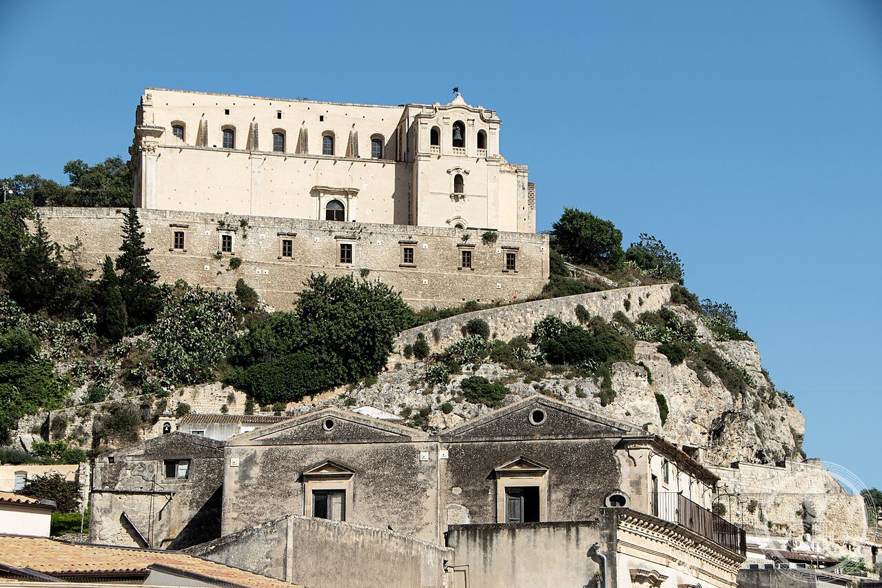
Il Palazzo Beneventano, il Municipio (commissariato Montalbano), San Giovanni Evangelista, la Rocca di San Matteo (the most precisely Scicli zone visit (2–3 hours): the walking circuit (the centro storico is entirely on foot: all sites within 600 m of the main axis Via Mormino Penna): (1) the Municipio / Commissariato di Vigàta (Via Mormino Penna 56; the Baroque townhall (1814 CE; the current facade replaces an earlier building; the Montalbano plaque on the portal; the courtyard (the original 18th-century courtyard is visible through the main portal even when the building is closed; Mon–Fri 9 AM–1 PM for interior access)); (2) the Palazzo Beneventano dell’Aquila (c.1770 CE; Via Mormino Penna, corner with Discesa Penna; the 9 mascheroni above the windows: examine each at close range; the ground-floor portal (the “Aquila” (eagle) above the gate is the arms of the Beneventano family; the 6 consoles below the balcony are in the form of human busts emerging from the wall at waist height)); (3) the church of San Giovanni Evangelista (Via Mormino Penna; 18th century CE; the baroque facade (concave central bay + convex lateral bays; the entablature breaks forward at each pilaster; the style is the most characteristic example of “curvilinear Val di Noto baroque”)); (4) the Rocca di San Matteo (the hill accessible from the stairs at Via San Matteo; 25-minute climb; the view from the top: the only point from which the entire street grid of post-1693 CE Scicli is visible; the 3 ruined Norman churches on the hilltop (the churches are open sky since 1693 CE; the nesting falcons and the carved portals still intact)).
Practical information
- Come organizzare il tour Montalbano da Ragusa Ibla e cosa fare a Scicli in mezza giornata: il tour Montalbano (Ragusa Ibla → Scicli → Modica in un giorno: auto obbligatoria per i collegamenti tra i 3 centri (i bus locali hanno orari infrequenti); distanze: Ragusa Ibla → Scicli = 26 km (25 min A23 Ragusa-Catania); Scicli → Modica = 12 km (15 min SS115)); il circuito Scicli (mezza giornata 9:30–13:30): (9:30) Municipio (check la targa Montalbano, il cortile; 15 min); (10:00) camminata su Via Mormino Penna; Palazzo Beneventano (mascheroni; 20 min); (10:30) San Giovanni Evangelista (facciata; interno; 20 min); (11:00) salita alla Rocca di San Matteo (25 min salita + 20 min in cima (vista 360°) + 20 min discesa); (12:30) pranzo: Osteria del Gallo (Via Francesco Mormino Penna 1; pasta alla norma, arancine, caponata siciliana autentica; €12–18; chiuso lunedì); (13:30) partenza per Modica; il gelato (il cioccolato di Modica (Modica è a 12 km; il cioccolato a freddo 500-year-old recipe; il Caffè dell’Arte in Corso Umberto I a Modica))
Getting there
Auto da Ragusa: A23 poi SS194 (26 km, 25 min). Trenitalia da Siracusa a Ragusa (2h, €9.50), poi bus locale Ragusa–Scicli (€2.50, 35 min). GPS Palazzo Beneventano: 36.7930, 14.7050.
Nearby
- Modica: Cioccolato e Val di Noto (UNESCO 2002) — 12 km nord-est (rif. 1024; Duomo di San Giorgio Gagliardi 1702–53 CE; il cioccolato a freddo 500-year-old recipe (€7–15/tavoletta; Caffè dell’Arte); auto 15 min)
- Ragusa Ibla: Duomo di San Giorgio (UNESCO 2002) — 26 km nord (rif. 1024; il “quartiere di Montalbano”; il Duomo di San Giorgio (Gagliardi 1738–75 CE; la facciata a torre convessa; il Giardino Ibleo); auto 25 min)
Gallery
Sources
- Wikipedia, Scicli; 1693 Sicily earthquake; Late Baroque Towns of the Val di Noto, accessed June 2026
- UNESCO, Late Baroque Towns of the Val di Noto (South-Eastern Sicily), WHS reference 1024, inscribed 2002
- Minissi, Franco. Il centro storico di Scicli. Palermo: Sellerio, 1980 (the primary architectural survey of the post-1693 Scicli reconstruction)
Find it on the map
See this place and what’s around it →📷 Diventa un fotografo di Cultural Heritage Online
Condividi le tue foto dei luoghi: restano pubblicate con la tua firma come autore. Più vengono viste, più ti fai conoscere — e presto un concorso premierà le foto più apprezzate.
Accedi o registrati gratis per aggiungere una foto