Rock Art of Valcamonica
The Val Camonica (Valcamonica) contains the largest collection of prehistoric rock carvings in Europe — over 300,000 individual petroglyphs incised between 8,000 BCE and 1,000 CE by the Camunian people across 70 kilometres of valley walls — and was Italy’s very first UNESCO World Heritage Site (1979, reference 94), recognized before Venice, Rome, Florence, or Pompeii.
At a glance
Rock Art Valcamonica (the most precisely ValcamonicaRockArt serial Brescia Lombardia Italy 46.0266 N 10.3461 E UNESCO WHS 1979 reference 94 first Italy: the Valcamonica (the Camonica valley, from the Latin “Vallis Camunia”; the valley of the Oglio river, a tributary of the Po; the valley runs 90 km from Breno (the historical capital) to Ponte di Legno at the Alpine watershed (elevation 1,258 m at Capo di Ponte; elevation 1,884 m at Ponte di Legno)); the petroglyph distribution: over 300,000 individual petroglyphs documented across approximately 2,500 individual rocks in 24 recognized sites; the Naquane National Park (Parco Nazionale delle Incisioni Rupestri di Naquane; Capo di Ponte; 104 ha; 1,000+ carved rocks; the largest single concentration of Camunian petroglyphs; 8 circuits of varying difficulty; the main circuit includes Rocks 1, 57, 23, and the Plemo area; open March–November, Tuesday–Sunday 8:30 AM–7:30 PM (summer) / 8:30 AM–5 PM (winter); €4 adults; €2 reduced); the Seradina-Bedolina park (the most complex single carved rock surface: the Bedolina Map rock (c. 2,000–1,000 BCE; 4.16m × 2.28m; the most complex single carved surface in the valley; the rock surface shows a topographic map of the valley floor with rectangular enclosures (fields?), paths between enclosures, and footprints; it is one of the earliest topographic maps in the world; the debate: whether the Bedolina surface represents an actual map of the valley floor or a cosmological schema); the age span: the petroglyphs span 10,000 years of human presence in the valley (8,000 BCE to 1000 CE) — covering the Epigravettian (8,000–5,000 BCE; the oldest figures are naturalistic animals — deer, oxen, dogs — and isolated geometric marks), Neolithic (5,000–3,000 BCE; the introduction of agricultural scenes, ploughs, enclosures), Copper Age/Chalcolithic (3,000–2,200 BCE; the peak of carving density; the introduction of weapons (daggers, axes) and the first figures with diagnostic human features), Bronze Age (2,200–1,000 BCE; the most complex narrative scenes (duels, rituals, hunting parties); the Camunian Rose appears in this period), Iron Age (1,000–200 BCE; the Camunian people under Celtic and then Cenomanic influence; the petroglyph density decreases; the figures become more schematic), and the Roman period (200 BCE–1,000 CE; Christian crosses and Latin inscriptions in the final layer).
Key facts
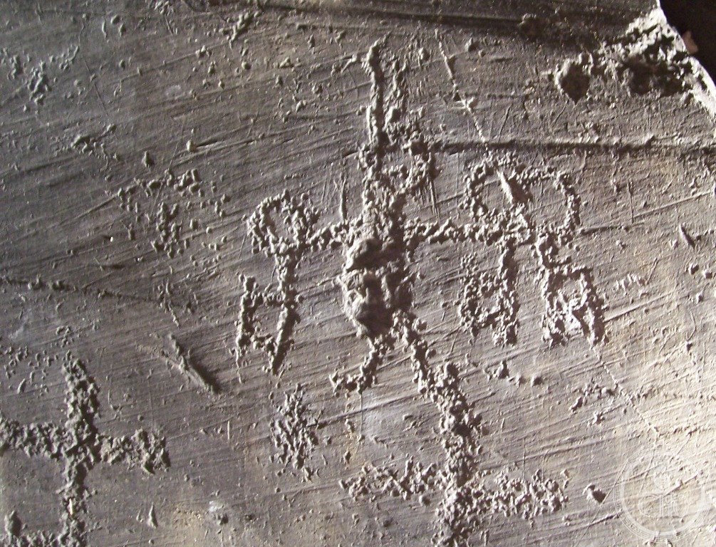
- The Camunian Rose and why it is the symbol of Lombardia: the Camunian Rose (Rosa Camuna; the Italian name rose — rosa — is a modern interpretation; the figure is technically a petroglyph of a 6-lobed flower-like geometric figure inscribed within a circle (or the circle itself); the figure appears over 90 times in the Valcamonica petroglyphs, concentrated in the Bronze Age/Iron Age layers (2,200–200 BCE); the specific Camunian Rose design: 6 curved petals arranged around a central point, each petal being a concave arc; the figure is roughly 20–40 cm across on the rock surfaces where it appears; the symbol is very widespread (the Camunian Rose design appears in Celtic contexts across northern Europe, in Scandinavian petroglyph traditions, and in prehistoric Irish stone art — the specific debate: whether the cross-European occurrence indicates a shared cultural convention or independent invention of a geometrically simple form; the Valcamonica scholars argue for cultural contact (the Camunian people were on the Alpine trading routes between the Mediterranean and northern Europe) while others argue for independent invention); the Lombardia symbol: the Camunian Rose was adopted as the official symbol of the Lombardia region by the Regional Council in 1975 CE (4 years before the UNESCO inscription; the adoption was proposed by the historian and Camunian petroglyph researcher Raffaele de Marinis); the Camunian Rose appears on all official Lombardia Regional Government documents, road signs, and stationery; it is the oldest continuously used symbol of any Italian administrative region (the figure is approximately 3,500 years old; the Lombardia regional government has used it for 50 years)
- GPS Naquane National Park: 46.0266° N, 10.3461° E (Capo di Ponte)
History
From Camunian culture to Celtic conquest to Roman submission to Alpine trade route to UNESCO first (the most precisely ValcamonicaRockArt single 8000 BCE earliest petroglyphs: the earliest Layer 1 petroglyphs (the Epigravettian layer; the oldest confirmed is approximately 8,000 BCE but some researchers argue for traces as old as 12,000 BCE; the dating methodology: the patina re-growth rate, the superimposition analysis (determining which figures were carved over others), and the comparison with archaeological strata at nearby excavation sites (the Cave of the Bears at Borno; the Riparo Valtenesi near Brescia)); the Camunian people: the ancient Camunians (Latin: Camunni; documented in Roman sources as Camunii; the first mention in Pliny the Elder, Naturalis Historia Book 3; a pre-Celtic Alpine people of uncertain origin; Pliny placed them among the Euganei (the pre-Celtic peoples of the Po plain); later archaeological research has suggested a connection to the Raetian culture (the Alpine people of Trentino/South Tyrol), whose language is documented in inscriptions from the 5th–1st century BCE; the Camunian language: documented in approximately 200 alphabetic inscriptions on rocks in the valley, written in the Venetian alphabet (the North Etruscan-derived writing system used in the Alpine region); the inscriptions have been partially deciphered but the language is still classified as a partially understood language); 16 BCE Roman conquest: Augustus organized the Alpine campaigns (the Raetian war; 16–15 BCE; the Camunians submitted to Rome in 16 BCE; the Roman pacification inscription at the La Turba pass (the “La Turba rock” at Pescarzo; the inscription, in Latin, records the submission of the Camunian tribes and was incised by Roman soldiers on the same rock surfaces previously used for prehistoric petroglyphs — making it the most recent layer in the Valcamonica sequence); 1929 CE systematic documentation: Raffaele Battaglia (geographer; University of Padova) published the first scientific documentation of the Valcamonica petroglyphs; 1979 CE UNESCO inscription reference 94 — the first Italian inscription; the UNESCO file was submitted in 1978 CE and approved at the 3rd session of the World Heritage Committee in Cairo in October 1979 CE (the session that inscribed 45 sites globally, including the Mesa Verde, Nahanni, Yellowstone, Galápagos, and the Simien Mountains among others — Italy received its first inscription in the company of the most recognized WHS sites of the first 5 years of the convention).
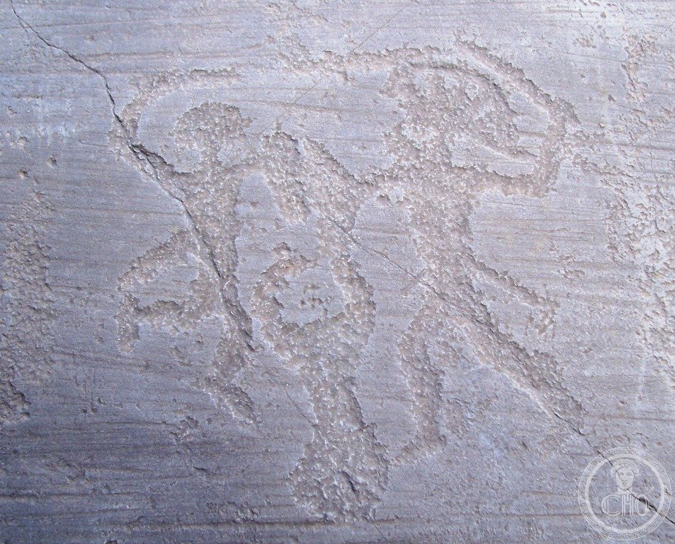
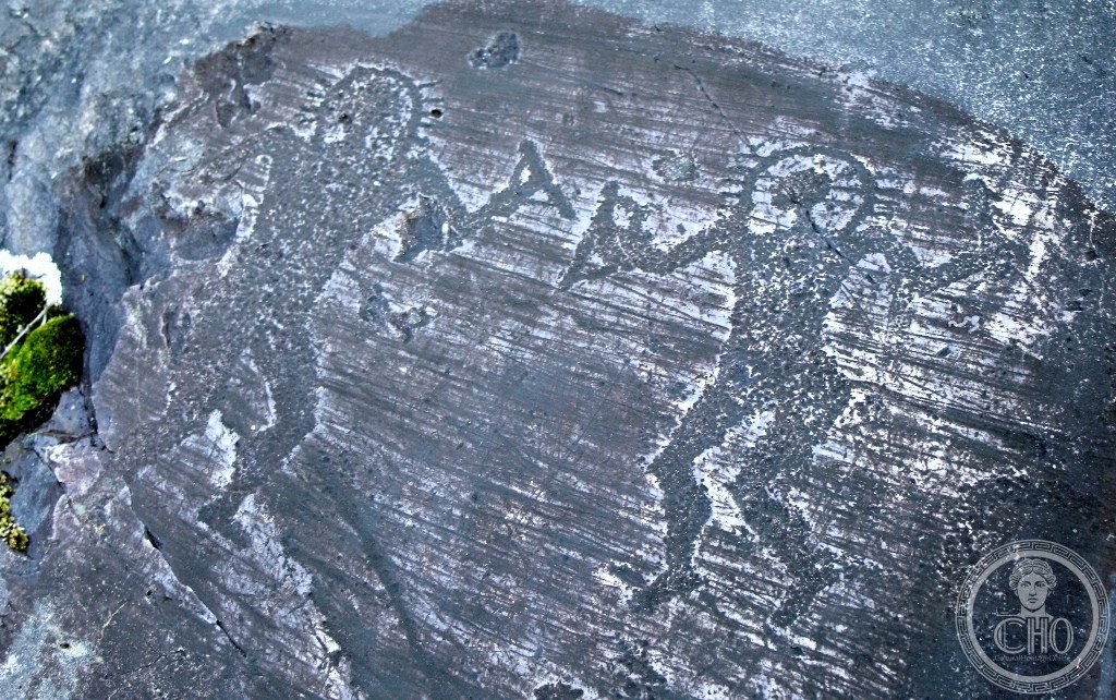
What you see
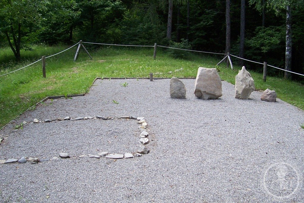
The Naquane circuit, the Seradina-Bedolina Map, and the MUPRE museum (the most precisely ValcamonicaRockArt single visit sequence: the main site concentration is between Capo di Ponte (the largest park) and Darfo-Boario Terme (45 km south); the recommended 1-day visit: 1) Naquane National Park (8:30 AM; arrive at opening to use the first morning light before tourist groups arrive; the visitor circuit is self-guided with bilingual Italian-English panels; the main objects: Rock 1 (the largest single decorated rock in the park; 14m × 19m; contains several thousand individual petroglyphs spanning all the Valcamonica periods; the concentration on Rock 1 is so dense that in places the carvings overlap in 5 or 6 layers); Rock 57 (the “Dueling Warriors” scene; the best-preserved Bronze Age martial scene in the valley; two figures with daggers in combat position); the Plemo area (the best concentration of Camunian Rose petroglyphs; the 6 Roses in this area are photographed from the east at midday when the light enters horizontally across the surface); the circuit takes 2.5–3 hours at moderate pace without a guide; guided visits in Italian €7 (advance booking at the park office; English-speaking guides are available); 2) MUPRE — Museo Nazionale della Preistoria della Valle Camonica (Capo di Ponte; the national museum of Valcamonica prehistory; the casts of key petroglyphs at indoor scale with interpretive material; the most important object: the full-scale cast of the Bedolina Map rock; open same hours as the park; included with park admission); 3) Seradina-Bedolina park (Capo di Ponte; 10 min walk from Naquane; the Bedolina Map rock (Circuit B of the Seradina-Bedolina park; the rock is visible from the path at 10m distance; low raking light from the east (morning) is essential for seeing the marks on the surface; the map-like composition (the rectangular enclosures, the paths, the footprints) is easiest to read in a photograph taken with strong sidelighting rather than direct observation; the park provides a tracing overlay at the entrance that helps visitors interpret what they see on the surface)).
Practical information
- Getting to Valcamonica and combining the visit with Lake Iseo and the floating piers: transport: the Brescia–Edolo Ferroviaria Brescia Nord railway line runs the length of Valcamonica (Brescia to Capo di Ponte: 1h45min; €8.50; hourly; the train is the single most cost-efficient way to reach the valley from Brescia or Milan); from Milan: train to Brescia (30 min, AV; or 55 min, regional) then change to Capo di Ponte (1h45min); total journey 2h15min–2h50min from Milan; admission: Naquane park €4 (€2 reduced); MUPRE museum included in park ticket; Seradina-Bedolina: separate €3 ticket; the combination ticket (Naquane + Seradina-Bedolina + MUPRE): €8; visiting in winter: the park is open year-round (November–February reduced hours; 8:30–4 PM); winter is the best season for seeing petroglyphs because the deciduous trees lose their leaves, allowing the low winter light to rake across the rock surfaces at longer angles; summer is the most crowded season (July–August); Lake Iseo combination: Lake Iseo (Lago d’Iseo; 20 km south of Capo di Ponte; 1 stop on the Ferroviaria from Pisogne; the lake is famous for Christo’s “Floating Piers” (2016 CE; no longer installed; the permanent memory of the installation is documented in the Sebino’s Permanent Art Museum at Sulzano); the Monte Isola island (the largest lake island in southern Europe by area; ferry from Sulzano; 7 km long; no private cars; the fishing village of Peschiera Maraglio; the traditional sardine-smoking facility (the rete-a-bottaccio method); the olive groves of the south shore))
Getting there
Train Brescia-Capo di Ponte (Ferroviaria Brescia Nord; 1h45min, €8.50; hourly). From Milan: train to Brescia (30-55min) + change (total 2h15min-2h50min). Open Tue-Sun 8:30-19:30 (summer) / 8:30-17:00 (winter). Admission €4 (MUPRE included; combo Naquane+Seradina+MUPRE €8). GPS: 46.0266, 10.3461.
Nearby
- Lake Iseo / Monte Isola — 20 km south (largest lake island in southern Europe; ferry from Sulzano; no cars; Peschiera Maraglio fishing village; 1h30min by boat around the island; the “Floating Piers” (Christo 2016) memory site at Sulzano)
- Brescia centro storico — 60 km south (Roman UNESCO WHS 2011 as part of “Longobards in Italy” site; the Capitolium temple (73 CE; the best-preserved Roman temple in northern Italy); the Museo di Santa Giulia (Benedictine monastery; the “Cross of Desiderius” (8th century CE Lombard treasure); the Roman domus with intact floor mosaics))
Gallery

Sources
- Wikipedia, Rock Drawings in Valcamonica; Camunian rose; Bedolina map; Camunni, accessed June 2026
- UNESCO, Rock Drawings in Valcamonica, WHS reference 94, inscribed 1979
- Anati, Emmanuel. Camonica Valley: A Depiction of Stone Age Life in Northern Italy. New York: Knopf, 1961
- Tognoni, Federico. Guida all’arte rupestre della Valcamonica. Edizioni del Centro, Capo di Ponte, 2018
Find it on the map
See this place and what’s around it →📷 Diventa un fotografo di Cultural Heritage Online
Condividi le tue foto dei luoghi: restano pubblicate con la tua firma come autore. Più vengono viste, più ti fai conoscere — e presto un concorso premierà le foto più apprezzate.
Accedi o registrati gratis per aggiungere una fotoDo you manage this place?
This page is read by travellers and heritage enthusiasts who find it on Google. Keep it accurate — and make it work for you. Free for non-profit heritage institutions.