Puma Punku
A component of the Tiwanaku complex on the Bolivian Altiplano, Puma Punku contains H-shaped stone blocks cut to tolerances of 6 millimetres — evidence of sophisticated pre-Columbian engineering carried out without iron tools, at 3,840 metres above sea level.
At a glance
Puma Punku — “Gateway of the Puma” in Aymara — occupies the south-western quadrant of the Tiwanaku ceremonial complex on the Bolivian Altiplano, 72 km west of La Paz. While Tiwanaku served as the capital of a pre-Columbian state that dominated the southern Andean region between roughly 500 and 1000 AD, Puma Punku is its most architecturally enigmatic precinct: a platform mound and associated plaza whose stone elements include interlocking H-shaped blocks, precisely bored drill holes, and ground-flat surfaces that meet at exact right angles — all achieved, according to current archaeological evidence, using bronze and stone tools combined with abrasive grinding. The thin Altiplano air at 3,840 metres sharpens every edge and turns the scattered grey andesite a startling silver-blue in afternoon light.
Key facts
- Period: c. 500–1000 AD (Tiwanaku IV–V cultural phases)
- UNESCO WHS: Designated 2000 as part of the Tiwanaku: Spiritual and Political Centre of the Tiwanaku Culture inscription
- Elevation: 3,840 metres above sea level
- Material: Red sandstone (quarried locally) and grey andesite (quarried from Copacabana Peninsula, ~90 km across Lake Titicaca)
- Largest block: ~131 tonnes (red sandstone)
- Precision documented by: Alexei Vranich and Jean-Pierre Protzen (2004 study); cuts consistent with hand-tool plus abrasive grinding methodology
- Access: Part of the Tiwanaku Archaeological Park; joint ticket with Tiwanaku site museum; guided tours available
History
The Tiwanaku state emerged on the shores of Lake Titicaca around 200 AD and reached its maximum territorial extent — covering parts of modern Bolivia, Peru, Chile, and Argentina — between approximately 500 and 900 AD. Tiwanaku was its ceremonial and administrative capital, a planned city of perhaps 15,000–20,000 inhabitants at its peak. Puma Punku was the state’s most ambitious architectural project: a raised platform measuring approximately 167 × 116 metres, surfaced with a complex of temple courts and plazas clad in precisely fitted stone.
The andesite used at Puma Punku presents an extraordinary logistical achievement. The nearest quarry for this material is on the Copacabana Peninsula of Lake Titicaca, approximately 90 km to the north-west. The Tiwanaku people had no wheeled vehicles and no large draught animals; archaeologists have proposed a combination of watercraft across the lake, wooden sleds, and organised labour gangs using ropes and earthen ramps to move blocks weighing up to 131 tonnes across flat terrain. Once at the site, craftsmen ground and shaped the andesite using harder stone tools and quartzite or obsidian abrasives, achieving the mirror-smooth surfaces and right-angle interiors visible today.
The site was destroyed — probably by a combination of earthquake and flooding — sometime around 1000 AD, before or concurrent with the broader collapse of Tiwanaku political authority. The blocks were later quarried for building material by Spanish colonial construction projects, and the site was extensively looted through the 19th and early 20th centuries. Systematic archaeological excavation began only in the 1970s under Carlos Ponce Sanginés and has continued intermittently. UNESCO recognised Tiwanaku including Puma Punku as a World Heritage Site in 2000.
What you see
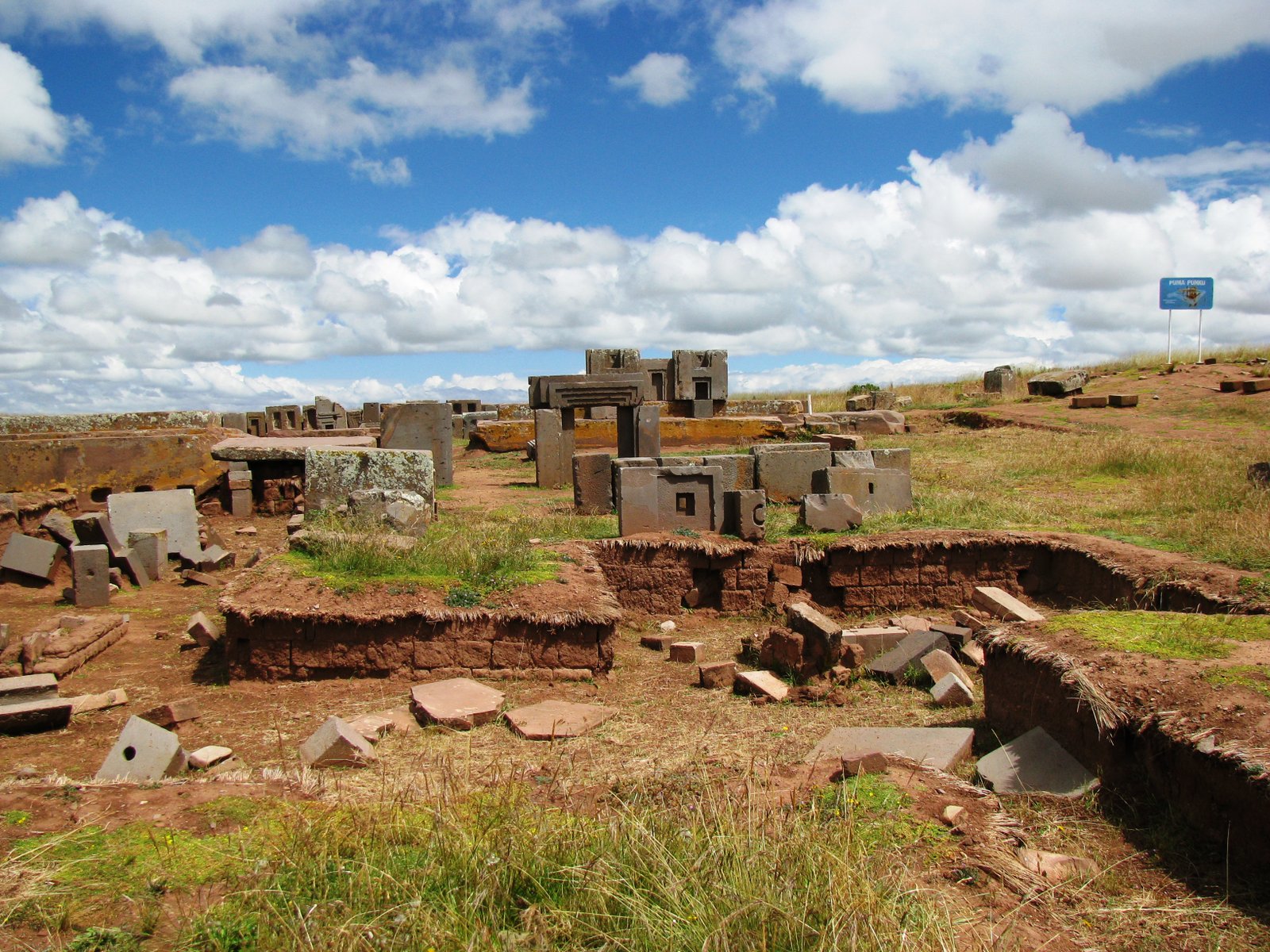
The site today presents a field of collapsed and scattered stone elements across the platform mound. The most discussed are the H-shaped blocks: modular units of grey andesite, each identically formed with projecting flanges and internal recesses designed to interlock with adjacent blocks without mortar. The precision of these elements — surfaces ground to within 6 mm of flatness, 90-degree interior angles, circular drill holes of consistent diameter and depth — has been measured and documented by archaeologists Alexei Vranich and Jean-Pierre Protzen, whose 2004 study concluded that all observed cuts and finishes are consistent with methods available to the Tiwanaku civilisation using bronze chisels, harder stone hammers, and fine abrasive compounds derived from locally available quartz. The study explicitly refuted claims that the precision required machine tools or non-human intervention.
Several red sandstone blocks, too large to have been moved after the collapse, remain near their original positions and give a sense of the platform’s original scale. The main staircase of the platform, partially reconstructed, ascends from the eastern approach. The site museum at the adjacent Tiwanaku complex holds the most complete carved stone elements, including the Bennett Monolith — a 7.3-metre basalt stela covered in carved anthropomorphic figures — excavated from Puma Punku in 1932 and now sheltered indoors. Visiting in the dry season (May–October) and arriving early allows the site to be seen in low-angle morning light, which reveals the texture and precision of the stone surfaces most clearly.
Practical information
- Opening hours: Tiwanaku Archaeological Park open daily 09:00–17:00
- Entry: Joint ticket covers both Puma Punku and the Tiwanaku ceremonial complex; fee moderate by international standards
- Altitude: At 3,840 m, acclimatisation is essential; arrive from La Paz after at least one night at altitude; symptoms of soroche (altitude sickness) — headache, nausea — are common; the site museum is a good first stop as it requires less exertion
- Best time: Dry season May–October; rainy season (November–April) can make paths muddy and obscure features under standing water
- Guides: Licensed guides available at the park entrance; strongly recommended for context
Getting there
Tiwanaku is accessible from La Paz by public bus (approx. 1.5 hrs, departing from the cemetery district of La Paz near Av. Kollasuyo) or by private taxi (approx. 1 hr). The town of Tiwanaku is 2 km from the archaeological site; tuk-tuks and taxis cover the gap. Several tour operators in La Paz offer half-day or full-day guided tours combining the Tiwanaku complex with Puma Punku. There is no direct international airport near the site; the access point is El Alto International Airport, La Paz.
Nearby
- Tiwanaku Ceremonial Complex (2 km east) — the Akapana pyramid, Kalasasaya temple, Semi-subterranean Temple with carved stone heads, and the original Puerta del Sol (Sun Gate) carved from a single andesite block
- Lake Titicaca (approx. 50 km north-west) — the highest navigable lake in the world; the Isla del Sol and Isla de la Luna hold pre-Inca and Inca ceremonial sites directly related to Tiwanaku-era religious traditions
- La Paz (72 km east) — Bolivian seat of government; the Museo Nacional de Arqueología holds additional Tiwanaku ceramics and textiles
Sources
- Wikipedia: Pumapunku
- UNESCO World Heritage Centre — Tiwanaku inscription (2000)
- Vranich, A. & Protzen, J.-P. (2004) — “The Tiwanaku Lapidary”; Proceedings of the 2004 Tiwanaku symposium
Find it on the map
See this place and what’s around it →📷 Diventa un fotografo di Cultural Heritage Online
Condividi le tue foto dei luoghi: restano pubblicate con la tua firma come autore. Più vengono viste, più ti fai conoscere — e presto un concorso premierà le foto più apprezzate.
Accedi o registrati gratis per aggiungere una foto