Phang Nga Bay
A 400-square-kilometre marine bay of vertical limestone karst islands in southern Thailand, made world-famous by James Bond and visited by millions annually for its geological spectacle.
At a glance
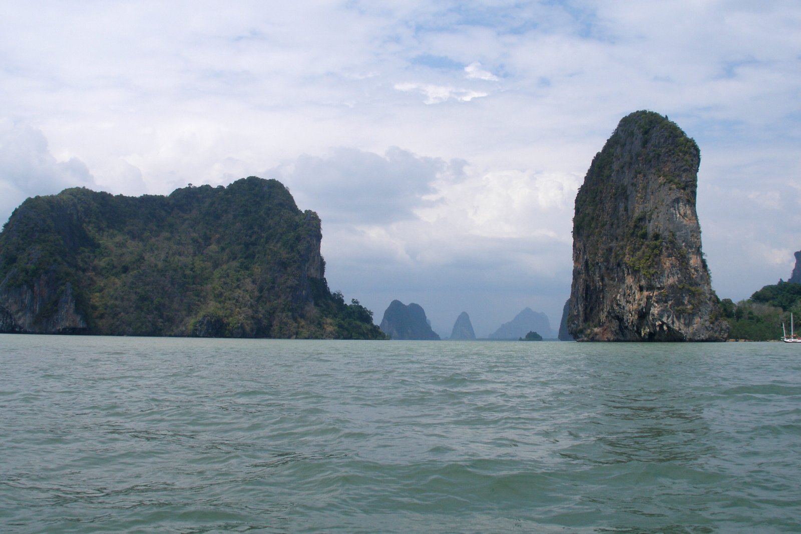
Phang Nga Bay is a shallow marine bay in Phang Nga Province of southern Thailand, covering approximately 400 square kilometres and containing around 40 vertical limestone karst islands that rise up to 300 metres above the sea surface from bases only metres wide. Their sheer white-grey cliffs, draped in hanging vegetation and undercut at the waterline into caves and enclosed tidal rooms accessible by kayak, create a seascape with no equivalent on Earth. The bay’s most iconic island, Ko Tapu, is a vertical limestone pillar approximately 20 metres tall with a base width of only 4 metres, photographed by perhaps a billion visitors and known worldwide as James Bond Island. It acquired its English nickname from The Man with the Golden Gun, filmed in 1974, in which Guy Hamilton used Phang Nga Bay as the setting for villain Scaramanga’s solar energy plant, preceding the area’s mass tourism development by nearly a decade.
Key facts
- Type: Marine bay with limestone karst islands, protected national park
- Area: c. 400 sq km; average depth 10 metres
- Geology: Permian-era limestone karst, 40-50 million years old
- Location: Phang Nga Province, southern Thailand, c. 95 km north of Phuket
- Film use: The Man with the Golden Gun (1974, James Bond); The Beach (2000, Phi Phi island nearby)
- Protected status: Ao Phang Nga National Park, established 1981
- Notable features: Ko Tapu (James Bond Island), Ko Panyi stilt village, prehistoric cave paintings, sea caves and hongs
History
The limestone karst landscape of Phang Nga Bay was formed during the Permian period approximately 40 to 50 million years ago, when marine sedimentary limestone was uplifted and sculpted by erosion into dramatic tower karst formations. Wave action at the waterline continues to undercut cliff bases, creating caves and enclosed tidal rooms known as hongs, accessible only by kayak through low tunnels at low tide. The bay’s shallow waters have been home to fishing communities for several centuries; the Muslim fishing village of Ko Panyi, built entirely on stilts over the water, has been continuously inhabited since the 18th century.
Prehistoric cave paintings in red haematite pigment, depicting human figures, animals, and fish, have been documented in several bay-accessible caves. The bay was established as Ao Phang Nga National Park in 1981. The event that catalysed its transformation into one of Southeast Asia’s primary tourist destinations was the filming of The Man with the Golden Gun in 1974: Guy Hamilton’s team discovered Ko Tapu and filmed Phang Nga Bay as the approach to villain Scaramanga’s lair. The film’s release brought the bay to international attention, and tourism infrastructure developed rapidly in the following decade.
What you see
The defining visual experience of Phang Nga Bay is the approach by longtail boat or kayak through a landscape of vertical stone. The karst towers rise from the flat water surface at right angles, their bases undercut into overhangs and caves, their flanks clothed in ferns, fig trees, and hanging vines. The colour spectrum ranges from grey-white cliff faces to rust and orange streaks of iron oxide, with the surrounding water reflecting a shifting palette of green and teal. The towers cluster in groups, so the boat moves through channels between walls of rock that open unexpectedly into broader bays and then narrow again.
Ko Tapu, the James Bond Island pillar, is a column wider at the top than the base — a natural stone mushroom, immediately photographable and memorable. The stilt village of Ko Panyi presents a dense cluster of wooden houses, mosque, school, and restaurants built on platforms over the water. The hongs are enclosed chambers with vertical rock walls open to the sky, populated by mangrove crabs, monitor lizards, and birdlife.
Practical information
- Access: Boat tours from Phang Nga town pier or from Phuket; standard tours 4-6 hours
- Kayaking: Sea-kayak tours to the hongs available; requires low-tide timing
- Ko Panyi: Lunch stop on most tours; floating football pitch and restaurants on-site
- Park fee: Ao Phang Nga National Park entrance fee applies
- Best time to visit: November to April; May-October possible but rougher seas
- Photography: Ko Tapu area crowded 10:00-14:00; early morning departure recommended
Getting there
Phang Nga Bay is most commonly reached from Phuket International Airport, approximately 95 km south. Organised tours depart from Phuket and from Phang Nga town pier. The town of Phang Nga is served by buses from Phuket, Surat Thani, and Krabi; most visitors arrange tours from Phuket or Khao Lak, approximately 30 km north of the bay.
Nearby
- Khao Sok National Park – Ancient rainforest and limestone karst reservoir, c. 60 km northeast
- Phi Phi Islands – Limestone karst islands including Maya Bay, used in The Beach (2000), c. 80 km south
- Phuket Old Town – Sino-Portuguese architecture, c. 95 km south
- Khao Lak – Quieter beach resort area with national park access, c. 30 km north
Sources
- Wikipedia, Phang Nga Bay
- Wikipedia, Ko Tapu
- Ao Phang Nga National Park official documentation
- IMDb, The Man with the Golden Gun (1974) filming locations
- Thailand Department of National Parks, Wildlife and Plant Conservation
Find it on the map
See this place and what’s around it →Historical events at this place (1)
📷 Diventa un fotografo di Cultural Heritage Online
Condividi le tue foto dei luoghi: restano pubblicate con la tua firma come autore. Più vengono viste, più ti fai conoscere — e presto un concorso premierà le foto più apprezzate.
Accedi o registrati gratis per aggiungere una foto