Palmanova — Città Stellata Veneziana
A Venetian ideal city founded in 1593 to a perfect nine-pointed star plan, Palmanova remains the most complete example of late Renaissance military urbanism in Europe — a working town preserved within its full circuit of bastions and moats.
At a glance
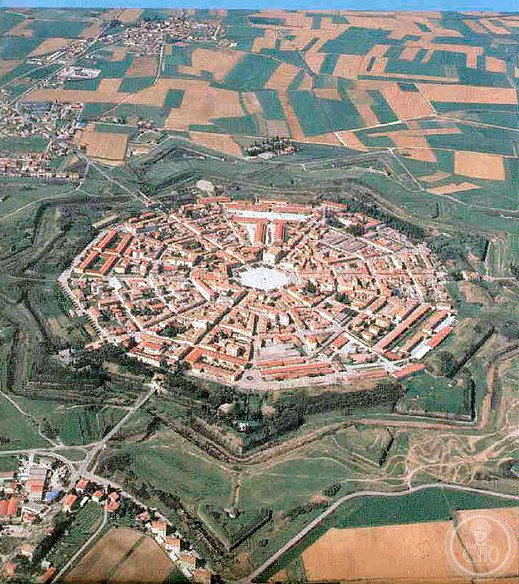
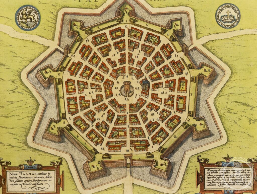
Palmanova was founded on 7 October 1593 by the Venetian Senate on a plain east of Udine, designed as both a defensive stronghold and a demonstration of Renaissance urban theory. The plan — a nine-pointed star with three concentric rings of fortifications — was drawn by Vincenzo Scamozzi and Giulio Savorgnan, applying the theoretical urbanism of Francesco di Giorgio Martini and Scamozzi’s own Idea dell’Architettura Universale. The city was built around a regular hexagonal piazza, from which six main streets radiate to the primary gates and three further streets reach the secondary bastions.
Inscribed as UNESCO World Heritage in 2017 as part of the transnational inscription “Venetian Works of Defence between the 15th and 17th Centuries: Stato da Terra — Western Stato da Mar”, Palmanova is one of the few planned Renaissance cities to have been inhabited continuously from foundation to the present day. It remains a fully functional comune of approximately 5,500 inhabitants.
Key facts
- Founded: 7 October 1593, by the Venetian Senate
- Designers: Vincenzo Scamozzi + Giulio Savorgnan (military engineer)
- Plan: Nine-pointed star, three rings of fortifications, hexagonal central piazza
- UNESCO inscription: 2017 — “Venetian Works of Defence”, ref. 1533
- Population: ~5,500 (2023)
- Province: Udine, Friuli Venezia Giulia
- GPS: 45.9044, 13.3102 — Google Maps
History
The Venetian Republic had controlled the Friuli plain since 1420. By the 1570s, the Ottoman advance after Lepanto (1571) and the threat of Habsburg expansion from the east convinced the Senate to commission a new defensive city on the Aquileia road. The site was chosen for its flat terrain and water availability, and the foundation stone was laid in 1593.
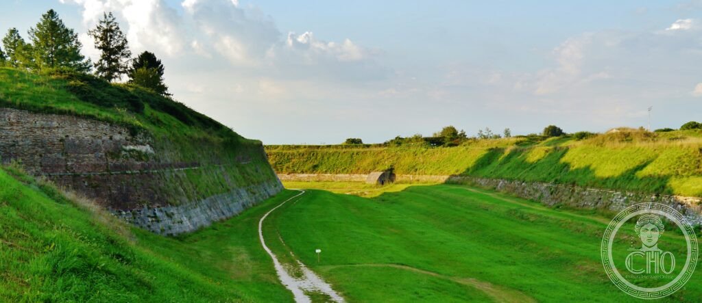
The original garrison never fully occupied the city. Venetian settlers were incentivised with tax exemptions, but take-up was slow, and the planned population of 10,000 was never achieved under Venetian rule. When Napoleon occupied Palmanova in 1797, he found a functioning but only partially filled city. The French completed the outer ring of fortifications, adding three additional gates and the third circuit of bastions between 1806 and 1813 — the construction visible today.
Palmanova passed to Austria in 1814, then to the Kingdom of Italy in 1866. Its fortifications were demilitarised in the 1860s but never dismantled — an unusual preservation outcome driven by the absence of urban pressure in this part of Friuli. By the time Italy began protecting the site, the entire star plan remained intact.
What you see
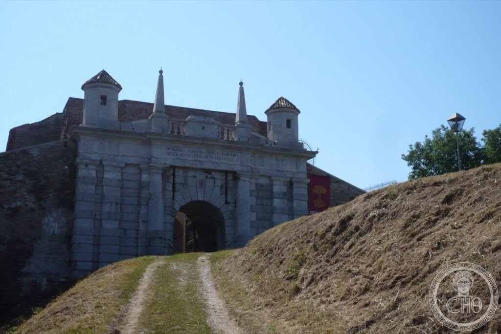
Approaching Palmanova by road, the first encounter is a gate: one of the three original Venetian portals (Porta Aquileia, Porta Udine, or Porta Cividale), each a monumental arched structure in Istrian stone, flanked by the earthen ramparts that still stand to their original height. The outer ditch — now dry, planted with grass — remains fully legible as a defensive feature.
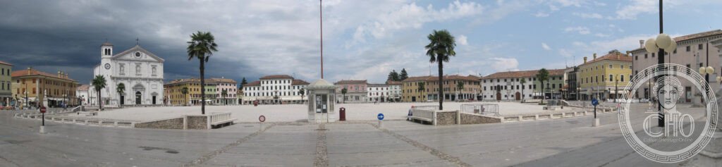
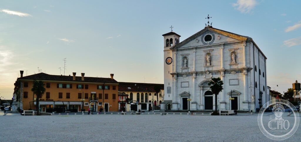
Inside the walls, the hexagonal piazza d’Armi is the geometric centre of the plan. From it, the six main streets run straight to the gates; six secondary streets connect the intermediate bastions. The 1593 grid has been respected without exception, producing a town where you can orient yourself entirely by the street layout. The central piazza is lined with logge from the seventeenth century; the cathedral, also seventeenth century, occupies one side. The scale is modest — this is a garrison town, not a courtly capital — but the rigour of the spatial system is striking in person in a way that no aerial photograph fully captures.
Gallery
Practical information
- Access: The town is fully open; no entrance fee or booking required.
- Guided tours: Available via the Museo Storico di Palmanova (Piazza Grande); book at the museo or online.
- Cycling: A cycle path runs along the top of the outer ramparts — full circuit approximately 4 km.
- Duration: 2–3 hours on foot for piazza, gates, and rampart walk; 1 day for museo and full circuit.
- Best time: Early morning (piazza in low light before tourist coaches arrive) or late afternoon (gates lit from the west).
Getting there
Palmanova is 22 km south-east of Udine on the SS352. By car from Udine: 25 minutes via SS352 (no motorway needed). Parking outside Porta Udine or Porta Aquileia — free, on the grass verges of the outer rampart. By bus: SAF service from Udine bus station, approximately 6 services per day (40 min). No rail service; nearest station is Cervignano del Friuli (Venezia–Trieste line), 12 km by taxi. Train from Venice Santa Lucia to Cervignano: 1h50 (Frecciarossa or regional).
Nearby
- Aquileia (UNESCO) — basilica with Roman floor mosaics, 15 km south
- Grado — lagoon island city, 25 km south
- Cividale del Friuli (UNESCO) — Lombard capital with Tempietto, 20 km north-east
Sources
- UNESCO World Heritage Centre: whc.unesco.org/en/list/1533
- Wikipedia EN: Palmanova
- Scamozzi, Vincenzo: Idea dell’Architettura Universale, Venice, 1615
- De Grassi, Mario: Palmanova — Fortezza e Città, Udine, 2004
Find it on the map
See this place and what’s around it →📷 Diventa un fotografo di Cultural Heritage Online
Condividi le tue foto dei luoghi: restano pubblicate con la tua firma come autore. Più vengono viste, più ti fai conoscere — e presto un concorso premierà le foto più apprezzate.
Accedi o registrati gratis per aggiungere una foto