
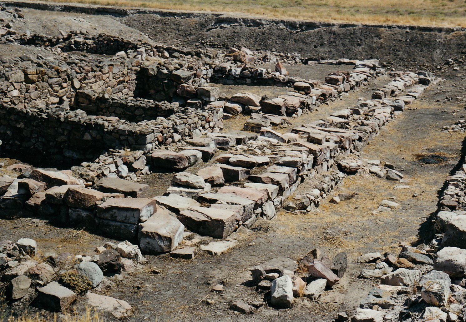
A Bronze Age city mound 20 kilometres northeast of Kayseri that has yielded more than 22,500 cuneiform clay tablets — the world’s largest archive of ancient commercial documents — left by Assyrian merchants who ran a sophisticated international trade network across Anatolia four thousand years ago.
At a glance
Kültepe (Turkish: ash mound) is a large tell preserving the remains of ancient Kanesh, one of the most important cities of Bronze Age Anatolia, and its attached Assyrian merchant quarter, the kārum. Between approximately 2000 and 1750 BCE, merchants from the city of Aššur in northern Mesopotamia settled here and operated the hub of a trading network spanning approximately 40 Anatolian colonies. The tablets they left behind constitute the earliest known private correspondence, the oldest documented commercial contracts, and the first written evidence of the Hittite language.
Systematic excavation has been under way since 1948 under Ankara University (Tahsin Özgüç and successors). The site is inscribed on Turkey’s Tentative UNESCO World Heritage List. The majority of the tablets are housed in the Museum of Anatolian Civilizations in Ankara.
Key facts
- Location: Approximately 20 km northeast of Kayseri city centre, Kayseri Province, Cappadocia region, central Turkey
- Period of significance: Early and Middle Bronze Age, c. 2500–1750 BCE; occupation evidence from Chalcolithic through early Iron Age
- UNESCO status: Turkey Tentative List (submitted)
- Tablets recovered: More than 22,500 cuneiform clay tablets — the largest single cuneiform archive found in Anatolia
- Language: Old Assyrian dialect of Akkadian; earliest known writing of Anatolian (proto-Hittite) names
- Trade commodities: Tin and textiles from Assyria exchanged for Anatolian gold and silver
- Excavation history: Systematic excavation from 1948 (Tahsin Özgüç, Ankara University); ongoing
History
Kanesh was already a thriving Anatolian city by the Early Bronze Age (c. 2500 BCE) when it appears in the regional record as a major urban centre of central Anatolia. Around 2000 BCE, merchants from the Assyrian city of Aššur (modern Qal’at Sherqat, Iraq) began establishing a permanent trading colony — the kārum — adjacent to the city mound. The kārum system was a sophisticated commercial institution: the word kārum originally referred to a riverside quay or trading dock, and by extension to a quarter where foreign merchants lived and worked under the protection of the host city, subject to its laws and to their own internal kārum assembly.
At Kanesh, the kārum operated in two main phases (Level II, c. 1975–1835 BCE, and Level Ib, c. 1800–1750 BCE) separated by a destruction episode. During these phases, Assyrian merchants transported tin (sourced possibly from Afghanistan or the Iranian plateau) and luxury textiles (produced by women in Aššur) westward by donkey caravan along a route of approximately 1,200 kilometres to Kanesh, where they were exchanged for gold and silver to be sent back to Aššur. The merchants maintained permanent households in the kārum, married locally, and raised families there over multiple generations.
The tablets they used to administer this trade — written on clay in cuneiform script, sealed in clay envelopes, and stored in private archives in their houses — survived because the houses were destroyed by fire, which baked the clay. The texts include trade agreements specifying prices and delivery schedules; business letters addressed between partners and family members; loan contracts with interest rates (including compound interest, the oldest known examples); marriage and adoption contracts; and records of commercial disputes adjudicated by the kārum assembly. Among the correspondents is Lamassī, a merchant’s wife whose letters to her absent husband describing the difficulties of managing the household in Aššur are the oldest known private letters written by a woman.
The tablets also contain the earliest written evidence of the Hittite language: Anatolian personal names — belonging to local rulers, trading partners, and employees of the Assyrian merchants — appear in the Old Assyrian documents as clearly non-Semitic names belonging to the ancestral language group that would develop into Hittite, Luwian, and Palaic. Kültepe/Kanesh is therefore the entry point of the Hittites into written history.
The kārum came to an end around 1750 BCE following a period of political disruption in Assyria and Anatolia. Kanesh itself continued to be inhabited, and the site preserves evidence of Hittite-era and later occupation, but the great archive period was over. The tell was first investigated by European travellers in the nineteenth century; the first scientific excavation was conducted by Bedřich Hrozný (famous for deciphering Hittite) in 1925. Systematic annual excavation began in 1948 under Tahsin Özgüç and has continued under his successors.
What you see
The site consists of two distinct areas: the city mound (tell or höyük), approximately 500 metres in diameter and 20 metres high, which preserves the remains of the ancient city of Kanesh itself; and the kārum area, a lower flat area to the northeast of the mound approximately 2 kilometres in diameter, where the Assyrian merchant quarter was located.
The excavated areas are partially open for visits. The city mound preserves architectural remains from multiple periods including a palace complex of the Middle Bronze Age with elaborate storage facilities. The kārum area has yielded the tablet archives but is now mostly backfilled after excavation to protect the remains. An on-site open-air shelter covers one excavated section.
A small on-site museum near the excavation houses selected finds including clay tablets, cylinder seals, and ceramic vessels. The principal collection — including the majority of the 22,500+ tablets — is in the Museum of Anatolian Civilizations in Ankara, where Kültepe material occupies a dedicated gallery. The Kayseri Archaeological Museum also holds significant Kültepe material.
Practical information
- Open: The archaeological site is generally accessible during daylight hours; confirm opening times with Kayseri Provincial Directorate of Culture and Tourism before visiting
- Entry: Fee applicable; included in Turkish museum pass (Müze Kart)
- On-site facilities: Limited; bring water and sun protection; no food vendors on site
- Museum: Museum of Anatolian Civilizations (Ankara) for primary tablet collection; Kayseri Archaeological Museum for local finds
- Best season: April–June and September–October for comfortable temperatures; July–August very hot
- Photography: Permitted on site
Getting there
Kültepe is located approximately 20 kilometres northeast of Kayseri city centre, accessible via the road towards Sarız. From Kayseri city, take a taxi or private vehicle (approximately 25 minutes); there is no direct public transport to the site. Kayseri Airport (ASR) has frequent connections to Istanbul, Ankara, and other Turkish cities. The site is approximately 300 kilometres southeast of Ankara (3.5 hours by road) and 350 kilometres from Cappadocia’s main tourist areas (Göreme/Ürgüp, approximately 1 hour by road from Kayseri).
Nearby
- Kayseri (20 km southwest) — major city with the Kayseri Archaeological Museum and Seljuk monuments
- Cappadocia (Göreme/Ürgüp, approximately 80 km west) — UNESCO World Heritage landscape of volcanic tuff formations, rock churches, and underground cities
- Alacahöyük (approximately 200 km northwest) — Hittite royal site with Bronze Age royal tombs and Sphinx Gate
- Hattusa / Boğazkale (approximately 215 km northwest) — Hittite capital, UNESCO World Heritage Site
- Museum of Anatolian Civilizations, Ankara (approximately 300 km northwest) — houses the majority of Kültepe’s cuneiform tablets
Sources
- Özgüç, Tahsin. Kültepe-Kaniš/Neša: The Earliest International Trade Center and the Oldest City in Anatolia. Middle Eastern Culture Center in Japan, 2003.
- Larsen, Mogens Trolle. Ancient Kanesh: A Merchant Colony in Bronze Age Anatolia. Cambridge University Press, 2015.
- Michel, Cécile. The Kārum of Kaneš. In: Oxford Handbook of the Archaeology of the Levant. Oxford University Press, 2014.
- Wikipedia contributors. Kültepe. Wikipedia, The Free Encyclopedia. Accessed June 2026.
Find it on the map
See this place and what’s around it →📷 Become a Cultural Heritage Online photographer
Share your photos of places: they stay published under your name as the author. The more they're seen, the more you get noticed — and soon a contest will reward the most appreciated photos.
Log in or sign up free to add a photo