Iguazú National Park
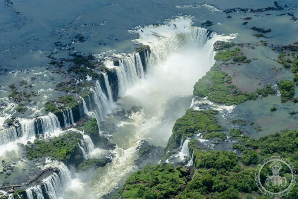
The most spectacular waterfall system in the world and one of the great natural wonders on Earth — Iguazú Falls, where the Iguazú River (a tributary of the Paraná) drops over a 2.7-km-wide basalt cliff in 275 separate cascades reaching 82 metres in height, straddles the border between Argentina and Brazil and can be heard from more than 20 kilometres away during the wet season.
At a glance
Iguazú National Park (UNESCO WHS Argentina 1984; UNESCO WHS Brazil 1986; the two national parks (Parque Nacional Iguazú on the Argentine side and Parque Nacional do Iguaçu on the Brazilian side) protect a total area of approximately 250,000 ha of subtropical Atlantic Forest on both sides of the Iguazú River; the most important natural context: Iguazú is one of the last significant remnants of the Atlantic Forest (Mata Atlântica; the most biodiverse forest in the Western Hemisphere; approximately 15% of original area remains; the Atlantic Forest once covered 1.5 million km² of coastal Brazil; it is now reduced to fragments protected in parks like Iguazú; more threatened than the Amazon rainforest by some measures)); the falls (the physical statistics: width: 2.7 km (the widest waterfall system in the world, wider than both Victoria Falls (1.7 km) and Niagara Falls (1.2 km); height: 60–82 m (comparable to Victoria Falls at 108 m and much higher than Niagara at 51 m); flow rate: average approximately 1,756 m³/s (the average is misleading; the wet season flow can reach 12,750 m³/s — one of the highest peak flow rates of any waterfall in the world); the individual falls (the 275 separate waterfalls (during high water; during low water, some dry up and the number falls to approximately 150; the most impressive single fall: the Garganta del Diablo (the Devil’s Throat; 82 m high; approximately 700 m wide; U-shaped; the confluence of the most powerful single flow in the system; the roar is audible from 25–30 km in the wet season; the spray (the mist cloud above the Garganta reaches 30 m above the waterfall; anyone standing on the viewing platform above the Garganta is soaked within 1–2 minutes regardless of rain gear); Eleanor Roosevelt’s reaction (when Roosevelt visited the falls in 1944 she reportedly said “Poor Niagara!” — the most quotable single comparison between natural wonders).
Key facts
- The Argentine side vs. the Brazilian side: which to visit and how — the Argentine side (the larger and more varied experience; the three circuits (Upper Circuit: the rim of the falls; the view from above; dry; safe; 650 m; excellent for the panoramic view of the whole system from above; the beginning of the Garganta walkway); Lower Circuit: the base of the falls; the path runs along the foot of the cliffs with the falls directly overhead; the most immersive experience; the spray is unavoidable; the best views of the San Martín falls (the second largest after the Garganta)); the Garganta circuit (the walkway that extends over the river to the platform directly above the Devil’s Throat; 1.1 km into the falls; the most extraordinary 10 minutes in any visitor’s experience of the falls; the raincoats (mandatory; the spray saturates clothing in under 2 minutes; the mist (despite the permanent mist, the view from the platform is one of the most visually dramatic natural views in South America); the motor launch ride to the falls (the Aventura Náutica; a motor launch that takes visitors directly under the San Martín waterfall; the most extreme water experience in the park; passengers are soaked to the skin within 30 seconds; the most fun optional extra); the Brazilian side (the single panoramic path along the cliff edge giving the widest view of the system; the path follows the canyon rim for approximately 1.2 km; the view is wider but more distant; the most photographed angle of the falls (the classic Iguazú Falls panorama image is always taken from the Brazilian side); the helicopter (the controversial helicopter rides over the falls from the Brazilian side; the Argentine and Brazilian park authorities and UNESCO have criticised them for disturbing wildlife; they continue to operate))
- The Atlantic Forest wildlife: what lives in the mist — the biodiversity (the Iguazú National Parks protect one of the most biodiverse regions in the western hemisphere; the key species: the jaguar (Panthera onca; the most important and rarest large predator in the park; approximately 50–80 individuals in the Iguazú protected area (the most important jaguar stronghold in the Atlantic Forest; the cameras set up by the park rangers record roughly 3–5 individuals per year); the tapir (Tapirus terrestris; the largest land mammal in South America; commonly seen at dawn near the hotel and along the lower circuit paths — the most accessible large mammal in the park); the coati (the South American coati (Nasua nasua); the raccoon-relative that crowds visitors on the park paths demanding food; the most commonly seen mammal in the park (and the most destructive for visitors’ packed lunches; the park rules prohibit feeding them; the rules are consistently ignored; the coatis know this)); the birds (the park is one of the finest birdwatching sites in South America; the most important species: the harpy eagle (Harpia harpyja; the most powerful eagle in the world (the most powerful talons of any bird; capable of taking monkeys and sloths from the canopy); the great dusky swift (Cypseloides senex; nests directly behind the water curtain); the toco toucan (Ramphastos toco; the most photographed toucan in the world); the purple-breasted cotinga (one of the most brilliantly coloured birds in the Atlantic Forest))
- The geography of the three-border area: how to plan the visit — the Tres Fronteras (the “Three Frontiers”; the point where Argentina, Brazil, and Paraguay meet at the confluence of the Iguazú and Paraná rivers; marked by obelisks in the three national colours (Argentine = blue and white; Brazilian = yellow and green; Paraguayan = red, white, and blue (the only country with different designs on each side of its flag)); the town of Ciudad del Este in Paraguay (the shopping mecca; the second-largest free trade zone in the world after Hong Kong; the most important destination for Brazilian shoppers (the most important cross-border shopping economy in South America; the Friendship Bridge (Puente de la Amistad; connecting Foz do Iguaçu in Brazil with Ciudad del Este in Paraguay; 50,000+ pedestrians and vehicles cross daily on busy weekends (the most used pedestrian crossing on any international bridge in the Americas))
- Heritage: UNESCO World Heritage Site, Iguazú National Park, Argentina inscribed 1984; Brazil inscribed 1986
- GPS: -25.6953° N, -54.4367° E (Garganta del Diablo)
History
The indigenous history (the area of the Iguazú Falls has been inhabited for at least 10,000 years; the indigenous Guaraní people (the most important indigenous nation of the Iguazú region; the name “Iguazú” from the Guaraní language (y = water; guasú = big; “big water”); the Guaraní myth (the legend of Naipi: the creator god Mboi had fallen in love with a mortal woman named Naipi; when she fled by canoe with her mortal lover, Mboi sliced the river with his tail creating the falls to punish her; the most romantic origin myth for any waterfall); the European discovery (the first European to see the falls: the Spanish explorer Álvar Núñez Cabeza de Vaca in 1541 (the explorer who had previously walked across the entire southern United States from Florida to the Gulf of California; the most extraordinary overland journey of any 16th-century explorer)); the national park (Argentine Iguazú National Park created 1934; Brazilian Parque Nacional do Iguaçu created 1939; UNESCO Argentina 1984; UNESCO Brazil 1986).
What you see
Planning the visit (the essential decision: Argentina (2 days) + Brazil (half day); the Argentine-side logistics (the park entrance fee (as of 2026 approximately ARS 5,000 for international visitors (approximately USD 5–15 depending on the exchange rate; the Argentine peso devaluation means checking the current rate is essential)); the Garganta circuit closes during high water (when the flow exceeds approximately 7,000 m³/s, the elevated walkway over the river is submerged; the most important planning point: check the river level before booking a specific circuit day); the best months (May–September; the dry season; the river flow is lower, the Garganta walkway is usually open, the heat and humidity are more manageable; October–February has higher water flow and more dramatic falls but is also hotter and more crowded); the best time of day (the Argentine upper and lower circuits face east and are best in the morning light; the Brazilian panoramic path faces west and is best in the afternoon).
Practical information
- Getting there: Cataratas del Iguazú International Airport (IGR) on the Argentine side (direct flights from Buenos Aires EZE/AEP; 1h 40min; multiple daily; the most common access); Foz do Iguaçu Airport (IGU) on the Brazilian side (flights from São Paulo and Rio; 1h 30min from São Paulo GRU); Puerto Iguazú (the Argentine gateway town; a pleasant, safe small city; the best hotel base; all accommodation types from hostels to the Belmond das Cataratas (the only hotel inside the Brazilian national park (directly beside the falls; the most extraordinary hotel location in South America; breakfast is taken with the sound of the falls in the background; the sunrise walk to the falls before public opening is the finest 20 minutes in Iguazú tourism))
- The Argentine economy: the dollar advantage and the complexity of exchange rates — Argentine prices in 2026 (the most practically important aspect of visiting Argentina for any non-Argentine visitor: the Argentine peso has experienced significant devaluation; international visitors who bring USD cash or use international credit cards may benefit from more favourable exchange rates than the official rate; the most important advice: check the current situation immediately before travel as exchange rate policy in Argentina can change rapidly (the most volatile exchange rate situation of any major tourist destination in South America); the result (Argentina is currently one of the most economical destinations for European and North American visitors relative to the quality of accommodation, food, and experiences on offer))
- Buenos Aires and the Pampas: the essential Argentine combination — Buenos Aires (the most European capital city in South America; the architecture (the Recoleta barrio (the 19th-century French Haussmann-inspired neighbourhood; the Recoleta Cemetery (the most important cemetery in South America; the burial place of Evita Perón (Eva Duarte de Perón; the most important female figure in Argentine political history; her vault is in the Duarte family mausoleum; the most visited single grave in the Western Hemisphere after Père-Lachaise in Paris)); the Palermo neighbourhood (the parks; the Museum of Fine Arts; the most important collection of 20th-century Argentine painting in the world); the tango (the most important Argentine cultural export; the tango milonga (the social tango dance events held in clubs throughout Buenos Aires every Thursday–Sunday; the most authentic tango experience available; the alternative: the tango shows for tourists (professionally excellent; socially artificial; the most tourist-oriented entertainment in Buenos Aires)))
Getting there
Cataratas del Iguazú Airport (IGR); flights from Buenos Aires 1h40. Brazilian side: Foz do Iguaçu Airport (IGU). GPS (Garganta del Diablo): -25.6953, -54.4367.
Nearby
- Jesuit Missions of the Guaraní (UNESCO WHS 1983/1984) — 100–350 km from Iguazú (1.5–4h by road); the most important Jesuit heritage in the Americas and the most remarkable social experiment in colonial history — the Jesuit Reductions (the system of mission towns (Reducciones) established by the Society of Jesus in the Guaraní territories of present-day Argentina, Brazil, Paraguay, and Uruguay (1610–1767; the most important Jesuit social experiment in the Americas; the reductions were self-governing Christian communities of Guaraní people operating outside the colonial slave economy (the most radical challenge to the colonial economic order in the Americas); the population at peak (approximately 150,000 Guaraní in 30 mission towns; the most prosperous and egalitarian communities in 18th-century South America by most economic measures; the suppression of the Jesuits (Pope Clement XIV suppressed the Society of Jesus in 1773; the most consequential single papal act of the 18th century for the indigenous peoples of South America; the 150,000 Guaraní Christians were abandoned to the slave traders and settlers without the protection of the Jesuit network; most of the mission towns were abandoned within a decade; the ruins: San Ignacio Miní (the best-preserved of the Argentine missions; 60 km from Iguazú; the most important UNESCO inscription in Misiones province))
- Pantanal (UNESCO WHS 2000) — 1,000 km north-west of Iguazú (1.5h flight or 12h+ by bus); the largest tropical wetland in the world and the finest wildlife experience in the Americas — the Pantanal (the most important wildlife watching destination in the Americas; the key statistics: area approximately 150,000–195,000 km²; the most flooded region on Earth (seasonally); the most important wildlife (the jaguar: the Pantanal has the highest jaguar density of any protected area in the world (1 jaguar per 10–15 km² in the best sections; the most reliable jaguar sighting destination in the world; the North Pantanal (around Cuiabá; the Porto Jofre section of the Pixaim River is the single best jaguar-watching location on Earth; a boat journey of 2h from Porto Jofre typically results in at least 1–2 jaguar sightings in the high season (July–October))
- Wonders of the Paraná River basin — the Itaipu Dam (25 km from Iguazú; the second-largest hydroelectric dam in the world (18.7 GW installed capacity; surpassed only by the Three Gorges Dam in China); the most important bi-national engineering project in South American history (shared equally between Brazil and Paraguay; the most complex international infrastructure sharing agreement in the Americas; the annual electricity generation (approximately 103 TWh in 2020 — the record year; equivalent to the entire electricity consumption of Paraguay plus 27% of Brazil’s total consumption); the free tours of the dam (the most surprising visitor experience near Iguazú: the Itaipu dam offers free guided tours in English and Portuguese/Spanish; the view from the top of the dam looking down at the 14-story-high concrete face is the most technically impressive engineering view in South America))
Sources
- Wikipedia, Iguazú Falls; Iguazú National Park; Atlantic Forest, accessed June 2026
- UNESCO, Iguazú National Park, WHS reference 303 (Argentina 1984) and 355 (Brazil 1986)
- Argentine National Parks Administration (APNAC), Iguazú visitor statistics, 2024
Find it on the map
See this place and what’s around it →📷 Diventa un fotografo di Cultural Heritage Online
Condividi le tue foto dei luoghi: restano pubblicate con la tua firma come autore. Più vengono viste, più ti fai conoscere — e presto un concorso premierà le foto più apprezzate.
Accedi o registrati gratis per aggiungere una foto