
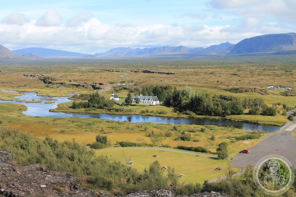
At Þingvellir, a rift valley splits open where two tectonic plates are slowly pulling apart, and the world’s oldest parliament once met on its floor. It anchors Iceland’s Golden Circle, a loop that also takes in an erupting geyser and a thundering two-tiered waterfall.
At a glance
Þingvellir National Park lies within Iceland’s Golden Circle, a touring route that also includes the Geysir geothermal area and the waterfall Gullfoss. The park sits where the North American and Eurasian tectonic plates meet, one of the few places on earth where that boundary is visible at the surface. It is also the site of the Althing, the assembly first convened here in 930 CE and regarded as the world’s oldest parliament, which met outdoors at the rock formation Lögberg until 1798 and continues to sit today in Reykjavík.
Key facts
- Location: Þingvellir National Park, Capital Region, Iceland
- Tectonic setting: the Almannagjá gorge, up to 32 metres deep and 7.7 km long, is the most visible rift valley at Þingvellir, formed as the two plates draw apart by roughly 2 cm a year
- Historical role: founding site of the Althing in 930 CE
- UNESCO status: inscribed as a World Heritage Site in 2004
- Golden Circle stops: Þingvellir, the Geysir geothermal field and the waterfall Gullfoss
History
Iceland was settled by Norse Vikings in the ninth century, one of the last places on earth to be reached by human settlement. Ingólfur Arnarson is credited with founding the first permanent settlement in 874 CE, at the site of modern Reykjavík. The Icelandic sagas, written down in the thirteenth century but describing events of the ninth to eleventh centuries, record much of this early history, including the Vinland sagas’ account of Leif Eriksson’s voyage to North America around 1000 CE.
The Althing was established at Þingvellir in 930 CE and is considered the world’s oldest operating parliament. In the year 1000, the assembly voted to adopt Christianity as Iceland’s official religion, a decision announced by the lawspeaker Þorgeir Ljósvetningagoði to avert civil war; he is said to have then thrown his own Norse idols into a nearby waterfall. Þingvellir National Park was inscribed as a UNESCO World Heritage Site in 2004.
What you see
The Almannagjá gorge cuts through Þingvellir, its walls marking the visible edge of the rift between the two tectonic plates; visitors can walk along the valley floor between them. Nearby, the clear glacial water of Silfra, fed by meltwater from Langjökull filtered through porous lava over decades, offers underwater visibility said to reach around 100 metres, and divers can touch both plates at once while suspended in the fissure.
Further along the Golden Circle, the Geysir geothermal field in the Haukadalur valley holds dozens of geysers, mud pools and hot springs. The Great Geysir, from which the word ‘geyser’ derives, is now largely dormant, but the neighbouring Strokkur erupts frequently and reliably, throwing water many metres into the air. At Gullfoss, the Hvítá River drops in two stages, said locally to take its golden colour from the light of the setting sun on the spray.
Practical information
- Golden Circle route: a self-drive loop from Reykjavík linking Þingvellir, Geysir and Gullfoss, usually managed in a single day with a hire car
- Northern Lights season: best viewed on clear, dark nights between September and March, away from city lights
- Blue Lagoon: a geothermal spa near Keflavík popular with visitors; booking ahead through the official site is advisable
- Ring Road: Route 1 circles the island’s coast and is typically driven over a week to ten days
Getting there
Iceland is reached by air through Keflavík International Airport, with onward travel to Þingvellir and the rest of the Golden Circle typically done by hire car from Reykjavík.
Nearby
- Vatnajökull National Park — around 350 km east of Reykjavík; Europe’s largest national park, home to the Vatnajökull glacier, Iceland’s largest, and inscribed as a UNESCO World Heritage Site
- Skaftafell — within Vatnajökull National Park; black basalt canyon country and the Svartifoss waterfall, framed by hexagonal basalt columns
- Jökulsárlón — glacial lagoon fed by the Breiðamerkurjökull outlet glacier, where icebergs calve and seals swim among the ice
- Faroe Islands — a group of volcanic islands southeast of Iceland, known for dramatic sea cliffs and Nordic-Celtic culture; not a UNESCO World Heritage Site, though it has been discussed as a candidate
Sources
- Wikipedia, Þingvellir
- Wikipedia, Geysir
- Wikipedia, Strokkur
- Wikipedia, Silfra
- Wikipedia, Gullfoss
- Wikipedia, Althing
- UNESCO, Þingvellir National Park, WHS reference 1152
Find it on the map
See this place and what’s around it →📷 Become a Cultural Heritage Online photographer
Share your photos of places: they stay published under your name as the author. The more they're seen, the more you get noticed — and soon a contest will reward the most appreciated photos.
Log in or sign up free to add a photo