
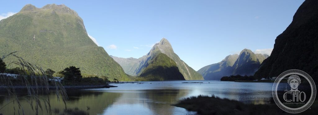
Fourteen fiords cut into the far south-west corner of New Zealand, carved by glaciers over 120,000 years. Milford Sound, where Mitre Peak rises straight from the water, draws the crowds; Doubtful Sound, three times deeper and reached only after three separate boat and bus connections, keeps them away.
At a glance
Fiordland National Park covers 1.2 million hectares of Southland, making it New Zealand’s largest national park. It contains fourteen fiords, though Milford Sound and its neighbours are technically fiords rather than sounds, since a sound is carved by a river and a fiord by a glacier — early British navigators mislabelled them and the name stuck. The landscape was shaped by glaciers during the last ice age, which reached its maximum extent around 20,000 years ago.
Milford Sound sits under some of the heaviest rainfall of any inhabited place on earth, and the run-off collects as a layer of tannin-stained fresh water two to three metres deep sitting on top of much deeper salt water, giving the fiord its dark, mirror-like surface on calm days.
Key facts
- Location: Fiordland National Park, Southland Region, South Island, New Zealand
- Extent: 1.2 million hectares, fourteen fiords
- Milford Sound (Piopiotahi): Mitre Peak rises 1,692 metres directly from the water
- Doubtful Sound: around 421 metres deep, roughly three times deeper and longer than Milford Sound
- Milford Track: a one-way walking route of 53.5 kilometres, usually taking four days
- World Heritage status: part of Te Wahipounamu (South West New Zealand), inscribed by UNESCO in 1990
History
The Māori name for Milford Sound, Piopiotahi, means “a single piopio bird”. Māori travelled through Fiordland to collect pounamu, the greenstone prized for tools and ornaments, carrying it north over mountain passes to their communities.
European contact came later: the sealer John Grono is recorded as the first European to enter Milford Sound, in 1823, naming it after Milford Haven in Wales. In 1888 Quintin Mackinnon and Ernest Mitchell became the first to walk the route that would become the Milford Track, discovering the pass that now bears Mackinnon’s name. The journalist and poet Blanche Baughan described the route in 1908 as “the finest walk in the world”, a phrase that helped fix its international reputation. The writer Rudyard Kipling separately called Milford Sound “the eighth wonder of the world”.
Fiordland forms part of Te Wahipounamu, inscribed by UNESCO as a World Heritage property in 1990.
What you see
Boat cruises on Milford Sound run past Mitre Peak and beneath Stirling Falls, which drop 151 metres directly into the fiord, before reaching the open Tasman Sea. Waterfalls appear on the cliff faces after rain, and in wet periods hundreds of temporary cascades can be seen at once.
An underwater observatory built at ten metres depth in Milford Sound gives access to black coral and sea urchins that normally live much deeper elsewhere; here the tannin-darkened fresh water filters out enough light that black coral survives far closer to the surface. The Tawaki, or Fiordland crested penguin, one of the rarer penguin species, breeds along the water’s edge in the park.
On the Milford Track, walkers cross Mackinnon Pass at 1,154 metres, with views down the Clinton and Arthur valleys towards the Tasman Sea. Doubtful Sound, reached only by boat, bus and a second boat, holds a permanent population of around sixty bottlenose dolphins, one of only two enclosed-water resident dolphin populations in New Zealand; they dive below the freshwater layer to hunt at depths people cannot follow.
Practical information
- Access to Milford Sound: by road from Queenstown through the Homer Tunnel, which crosses an avalanche zone and can be closed in winter, or by scenic flight from Queenstown
- Access to Doubtful Sound: requires three separate legs — a boat across Lake Manapouri, a bus over Wilmot Pass Road, then a boat onto the sound itself
- Milford Track: independent walker numbers are limited and bookings open a year ahead; check the official Department of Conservation channels for current arrangements
- Best conditions: an overnight cruise on Milford Sound avoids the day-trip crowds, and early morning is quietest for kayaking
Getting there
Queenstown is the usual gateway, with onward travel to Milford Sound by road, a journey of some 295 kilometres through the Homer Tunnel, or by a short scenic flight. Doubtful Sound is reached from Manapouri via the boat, bus and boat combination described above rather than by road.
Nearby
- Queenstown — around 295 kilometres east of Milford Sound; a centre for adventure tourism including jet boating on Skippers Canyon, white-water rafting on the Shotover River, and the Kawarau Bridge, site of the first commercial bungee jump in 1988; nearby Arrowtown is a former gold rush settlement and the region has a wine trail known for Pinot Noir
- Aoraki / Mount Cook — about 400 kilometres northeast, roughly five hours’ drive via Queenstown; New Zealand’s highest peak at 3,724 metres, part of the same Te Wahipounamu World Heritage property as Fiordland; Edmund Hillary trained here before his Everest expedition; nearby is the Tasman Glacier, New Zealand’s longest at 23 kilometres, and the Hooker Valley walking track leads to views of Aoraki across a glacial lake
- Rakiura National Park / Stewart Island — around 200 kilometres south, reached by ferry from Bluff or by short flight; known as a place to see kiwi in the wild at night, particularly around Mason Bay, and for the three-day Rakiura Track; on clear winter nights the Aurora Australis can sometimes be seen
Sources
- Wikipedia (Milford Sound; Fiordland National Park; Milford Track; Doubtful Sound)
- UNESCO, Te Wahipounamu (South West New Zealand), World Heritage reference 551
Find it on the map
See this place and what’s around it →📷 Become a Cultural Heritage Online photographer
Share your photos of places: they stay published under your name as the author. The more they're seen, the more you get noticed — and soon a contest will reward the most appreciated photos.
Log in or sign up free to add a photo