Huánuco Pampa
The most complete and best-documented Inca provincial administrative city in the Andes — 3,500 stone structures on a high plateau, built by imperial decree as a planned state redistribution and ceremonial centre, never organically inhabited.
At a glance
On a high plateau at approximately 3,750 metres altitude in the Department of Huánuco in central Peru, approximately 140 km north of the city of Huánuco, the planned Inca administrative city of Huánuco Pampa covers approximately 2 km² and preserves some 3,500 individual stone structures — storehouses, residential compounds, a royal palace, the largest ceremonial plaza in the Inca world, an acllawasi (house of the chosen women), a sun temple, and a network of roads connecting to the Qhapaq Ñan. Excavated by Craig Morris and Donald Thompson of the American Museum of Natural History between 1966 and 1976, it is the most thoroughly documented provincial Inca city and remains one of the best-preserved examples of Inca urban planning anywhere in the Andes.
Key facts
- Period: c. 1460–1532 AD (Inca Empire, Late Horizon)
- Altitude: approximately 3,750 metres above sea level
- Area: approximately 2 km²; some 3,500 surviving stone structures
- Central plaza: approximately 550 × 360 metres — the largest open ceremonial space in the Inca world
- Storage: approximately 500 qollqa (storehouses) on the surrounding hillsides
- Excavators: Craig Morris and Donald Thompson, American Museum of Natural History, 1966–1976
- Character: a planned city built from scratch — a periodic assembly centre, not a permanently inhabited town
History
Huánuco Pampa was built from scratch approximately 1460 AD by imperial Inca decree on previously uninhabited plateau, as part of the systematic Inca strategy of constructing provincial administrative centres along the Qhapaq Ñan at regular intervals throughout the empire. It was designed not as a conventionally inhabited city but as a periodic assembly and redistribution centre — occupied for major state ceremonial occasions, for the processing and redistribution of mit’a labour products (compulsory state labour obligations), and for the mobilisation and feeding of armies and corvée work parties. In between these events, it was substantially deserted.
The site’s function is revealed by the scale of its storage system: approximately 500 qollqa (circular and rectangular storage buildings) ranged on the hillsides overlooking the city, each identifiable by its plan, capable collectively of holding enough food, textiles, and other goods to feed and equip thousands of people simultaneously. The central plaza — at approximately 550 × 360 metres the largest open ceremonial space known in the Inca world — was designed to assemble this workforce for the state ceremonies that activated and legitimised the redistribution system. Craig Morris’s pioneering analysis of ceramic evidence from the site demonstrated that the predominant activity in the buildings flanking the plaza was the production and consumption of chicha (maize beer) at state-sponsored feasts.
What you see
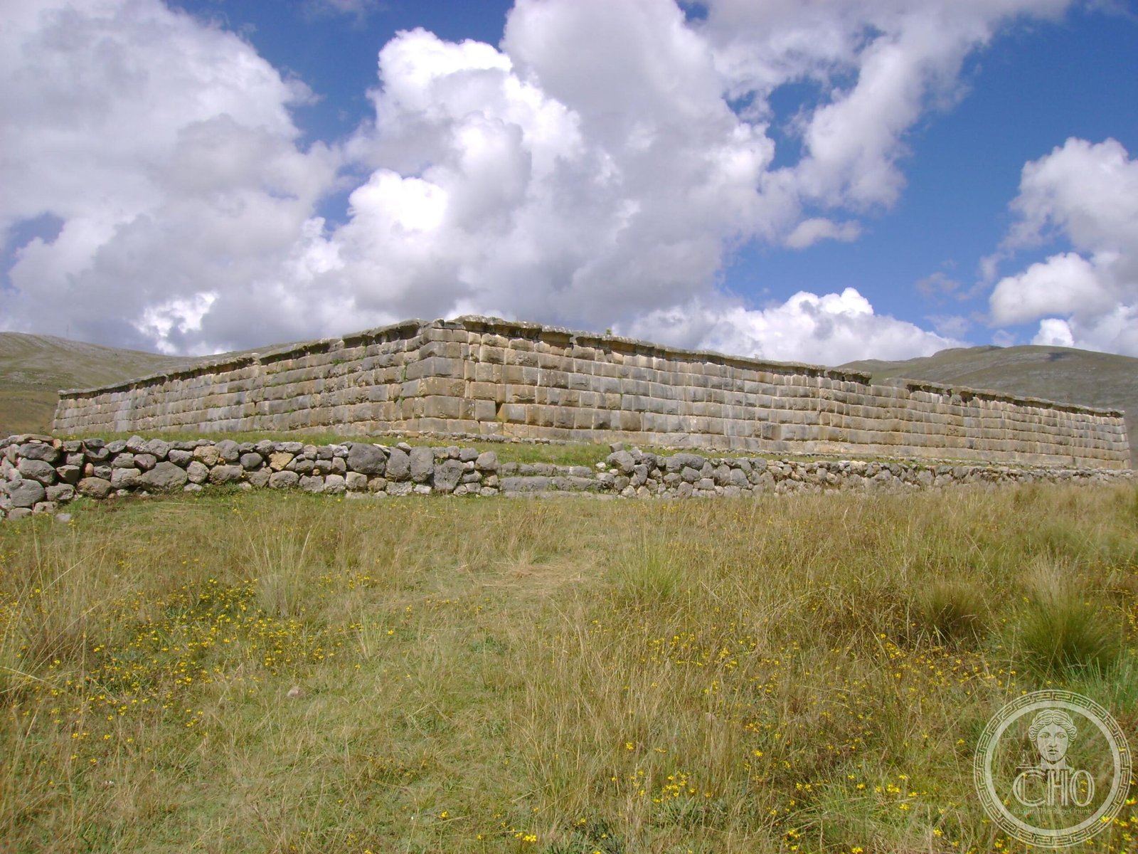
The site’s most immediately impressive feature is the scale of the central plaza — nearly 200,000 m² of open space, framed by long rectangular halls (kallanka) on at least two sides, and dominated at its centre by the ushnu, a stepped platform used for libation offerings and state ceremonies presided over by the local Inca governor (tukrikuq). The kallanka buildings are among the largest rooms ever built in the pre-Columbian Andes — some exceed 70 metres in length — designed to shelter large numbers of people assembled in all weather conditions.
The residential compounds, acllawasi, and administrative palace sectors cluster around and beyond the plaza. The qollqa on the surrounding hillsides are clearly legible in their two standard forms: circular qollqa (typically for freeze-dried potato and freeze-dried meat) and rectangular qollqa (for dried maize and other goods), sorted by the environmental requirements of their contents. The road connections — branches of the Qhapaq Ñan — enter the site from multiple directions, their causeways still visible crossing the plateau.
Practical information
- Access: the site is remote; no formal visitor infrastructure comparable to Cusco-area sites
- Getting there: requires a vehicle; the site is approximately 4 hours by road from Huánuco city
- Condition: ruins are unrestored; stone structures survive to varying heights across 2 km²
- Best season: dry season (May–October) recommended; the plateau can be very cold and wet in the rainy season
- Combination: often paired with visits to the Inca road (Qhapaq Ñan) sections visible in the region
Getting there
Huánuco Pampa is approximately 140 km north of the city of Huánuco in central Peru, reached via the road running north through the Huallaga valley then east toward La Unión. The journey from Huánuco city takes approximately 4 hours by road. The town of La Unión (Dos de Mayo Province), approximately 10 km from the site, is the practical base for overnight visits. From Lima, the city of Huánuco is approximately 6–7 hours by road or accessible by daily flights. A 4WD vehicle is recommended for the final approach in the rainy season.
Nearby
- La Unión (Dos de Mayo): 10 km — nearest town with accommodation and services
- Tantamayo: approximately 2 hours north — ruins of the pre-Inca Yarowilca culture, dramatically sited
- Kotosh: 4 km west of Huánuco city — one of the oldest ceremonial sites in the Americas (3,000 BC)
- Qhapaq Ñan sections: multiple visible sections of the Inca road in the Huánuco region
Sources
- Morris, C. & Thompson, D.E. Huánuco Pampa: An Inca City and Its Hinterland. Thames & Hudson, 1985.
- D’Altroy, T.N. The Incas. Blackwell, 2002.
- Morris, C. The Infrastructure of Inka Control in the Peruvian Central Highlands. In The Inca and Aztec States, Collier et al. eds. Academic Press, 1982.
- Wikipedia: Huánuco Pampa
- UNESCO Qhapaq Ñan: whc.unesco.org
Find it on the map
See this place and what’s around it →📷 Diventa un fotografo di Cultural Heritage Online
Condividi le tue foto dei luoghi: restano pubblicate con la tua firma come autore. Più vengono viste, più ti fai conoscere — e presto un concorso premierà le foto più apprezzate.
Accedi o registrati gratis per aggiungere una foto