
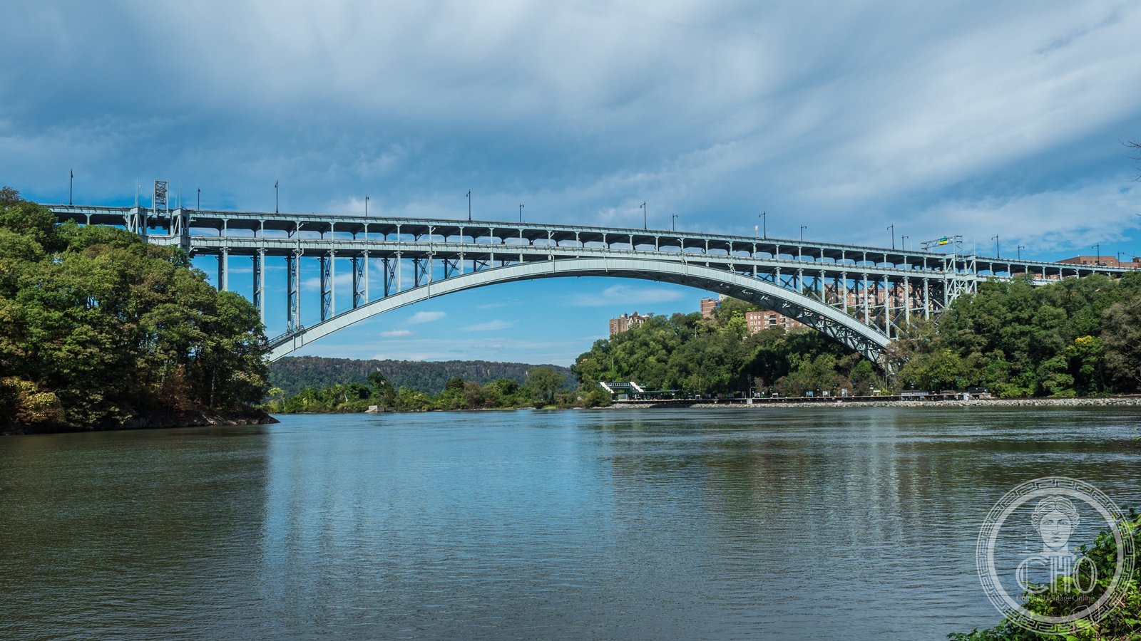
The northernmost crossing on Manhattan Island — a clean Art Deco steel arch carrying the Henry Hudson Parkway over the Harlem River Ship Canal, opened December 12, 1936 as the first structure of Robert Moses’s great parkway project along Manhattan’s western edge.
At a glance
The Henry Hudson Bridge spans the Harlem River Ship Canal at Spuyten Duyvil — the historic confluence of the Harlem and Hudson rivers at the northern tip of Manhattan Island. Designed by engineer David B. Steinman and opened on December 12, 1936, the bridge was the critical link in Robert Moses’s Henry Hudson Parkway, which ran along the western shore of Manhattan from Battery Park to the Bronx. The structure’s Art Deco character is expressed in its clean lines, smooth concrete approach ramps, and the graceful arc of its steel tied-arch span: unornamented but precisely proportioned, exemplifying the parkway aesthetic Moses imposed on all of New York’s major 1930s public works.
Key facts
- Location: Spuyten Duyvil, Manhattan / Riverdale, Bronx, New York City.
- Engineer: David B. Steinman.
- Style: Art Deco / Streamline Moderne parkway architecture.
- Opened: December 12, 1936.
- Type: Steel tied-arch.
- Carries: Henry Hudson Parkway (Route 9A) + pedestrian/bicycle path on lower level.
History
The Henry Hudson Bridge was the linchpin of Robert Moses’s parkway project — a landscaped automotive route Moses built along the western edge of Manhattan between 1936 and 1937. Moses, then simultaneously Parks Commissioner and chair of the Triborough Bridge Authority, used the parkway to connect parks, playgrounds, and recreation facilities along the Hudson shore. The bridge at Spuyten Duyvil was the essential link: without a crossing here, the new parkway could not continue north to the Bronx River Parkway and Westchester County beyond.
David B. Steinman was one of the country’s leading bridge engineers at the time of the commission. He had designed the St. Johns Bridge in Portland, Oregon, completed in 1931, and would later design the Mackinac Bridge in Michigan, completed in 1957. For the Henry Hudson crossing, Steinman chose a tied-arch design — in which the arch’s outward thrust is absorbed by horizontal tie members at deck level — that was structurally efficient and kept the visual profile clean and horizontal. Construction began in 1935 and the bridge opened the following year, ahead of schedule.
Henry Hudson himself had explored the waterway at Spuyten Duyvil in September 1609 aboard the Half Moon, making this one of the oldest European-named places in what would become New York. The Dutch colonial name “Spuyten Duyvil” — meaning “in spite of the devil” or “spitting devil” — appears in early colonial documents referring to the treacherous tidal currents at the confluence of the two rivers. When Moses built the bridge here three centuries later, he was placing a monument at one of the oldest named places in the city.
What you see
The Henry Hudson Bridge presents its best face from below, seen either from Inwood Hill Park on the Manhattan side or from the Riverdale waterfront on the Bronx side. The steel arch — painted a deep green-gray — sweeps between the two shores in a clean parabolic curve, its deck suspended from vertical hangers. The approach structures, in concrete with simplified flat moldings and pilasters, embody the Art Deco parkway aesthetic: no ornate detail, but careful proportions and deliberate attention to how the structure meets the landscape. The bridge does not announce itself; it simply appears as a clean arc against the sky, an engineering solution that is also a composition.
At the center of the arch, the bridge provides sufficient clearance for commercial vessels to pass between the Hudson and the Harlem rivers. Pedestrians and cyclists share a path on the outer edge of the lower deck — the view upstream toward the Palisades and downstream toward the George Washington Bridge is among the finest urban vistas in New York. Inwood Hill Park, directly below and east of the Manhattan approach, preserves the last natural forest in Manhattan and the site of a significant Lenape settlement.
Practical information
- Toll: Electronic toll collection (E-ZPass or cash at staffed lanes) for northbound traffic on the Henry Hudson Parkway.
- Pedestrians/cyclists: A dedicated path runs along the lower level of the bridge; access from Inwood Hill Park (Manhattan) or Palisade Avenue (Bronx).
- Photography: The bridge is best photographed from the Riverdale waterfront (Bronx side) or from Inwood Hill Park.
- Parking: Limited street parking at Inwood Hill Park; larger lots at Riverdale Park on the Bronx side.
Getting there
Take the A train to Inwood-207th Street — the last Manhattan stop — and walk north through Inwood Hill Park to the bridge approach, approximately 15 minutes. The 1 train stops at 225th Street in the Bronx (Riverdale), a short walk west to the Bronx approach. By car from Midtown Manhattan, the Henry Hudson Parkway runs directly to the bridge from the 79th Street Boat Basin; the drive in light traffic takes about 25 minutes. From Westchester County or the Bronx, take the Henry Hudson Parkway or the Riverdale Avenue route south.
Nearby
- Inwood Hill Park — the last natural forest in Manhattan, with pre-Columbian Native American cave shelters and the traditional site of the 1626 Dutch colonial purchase of Manhattan Island.
- The Dyckman Farmhouse (1784) — the last surviving Dutch colonial farmhouse in Manhattan, three blocks south of the bridge approach at 4881 Broadway.
- Wave Hill — the historic Bronx estate with Hudson River gardens and cultural programming, two miles north in Riverdale.
- Van Cortlandt Park — one of the largest parks in New York City, directly north of Riverdale, with forested trails and the Van Cortlandt House Museum (1748).
Sources
- MTA Bridges and Tunnels, Henry Hudson Bridge, official information.
- Wikipedia, “Henry Hudson Bridge”
- Caro, Robert A., The Power Broker: Robert Moses and the Fall of New York, Knopf, 1974.
- Steinman, David B., bridge engineering records, Columbia University Libraries.
Find it on the map
See this place and what’s around it →Record researched and written by Luigi De Marchi for Cultural Heritage Online, 2026.
📷 Become a Cultural Heritage Online photographer
Share your photos of places: they stay published under your name as the author. The more they're seen, the more you get noticed — and soon a contest will reward the most appreciated photos.
Log in or sign up free to add a photoIs this page about you?
This page is read by travellers and heritage enthusiasts who find it on Google. Tell us how you are connected to this place and we will take it from there.