Head-Smashed-In Buffalo Jump
The world's largest and most consistently used buffalo drive site: a sandstone cliff on the Alberta prairie edge where the Blackfoot Confederacy drove bison herds to their deaths for approximately 5,800 consecutive years, from c. 3600 BC to the late 19th century, leaving 12 metres of compressed bone deposits — one of the deepest archaeological layers in North America. UNESCO-inscribed in 1981.
At a glance
On the edge of the Porcupine Hills where they meet the Alberta prairie, approximately 18 km west of Fort Macleod, the sandstone cliff at Head-Smashed-In was used by the Blackfoot Confederacy and their ancestors to drive bison herds off a 10-metre drop to their deaths below — a communal hunting technique (the “piskan” drive) employed at this specific location for approximately 5,800 consecutive years, from c. 3600 BC to the late 19th century. The accumulation of butchering deposits below the cliff reaches 12 metres deep, representing one of the deepest and richest archaeological layers in North America. UNESCO inscribed the site in 1981, and the interpretive centre designed in 1987 presents the site's archaeology and Blackfoot oral history under Piikani First Nation guidance.
Key facts
- Location: 18 km west of Fort Macleod, Alberta, Canada
- UNESCO WHS: 1981
- Period of use: c. 3600 BC – late 19th century (approximately 5,800 years continuous use)
- Cliff height: Approximately 10 metres; bone deposit depth: up to 12 metres
- Drive lane distance: Approximately 3–4 km of cairn-marked approach lanes
- First Nations: Blackfoot Confederacy (Piikani / Peigan, Siksika, Kainai)
- Interpretive Centre: Designed by Robert LeBlond, 1987; integrated into the cliff face
History
The communal bison drive — called “piskan” in Blackfoot — was the economic and cultural foundation of the Northern Plains peoples for millennia before European contact. The technique required sophisticated landscape management and collective action: men and women placed stone cairns in V-shaped lanes stretching 3–4 km across the prairie, guiding a bison herd toward the narrowing approach to the cliff. Runners posted behind the cairns waved bison-skin robes and shouted to keep the animals moving forward; as the drive lane narrowed and the animals crowded together, the momentum of the herd prevented the lead bison from stopping, driving them over the 10-metre cliff. Below the cliff, hundreds of animals could die in a single drive event; the entire community processed the carcasses immediately, preserving meat by drying, making pemmican (dried meat mixed with fat and berries), tanning hides for clothing and shelter, and using bones for tools. A single successful drive could sustain a band through the winter.
Head-Smashed-In takes its name from a Blackfoot oral tradition: a young man who wanted to watch the bison fall from below the cliff was buried under the falling carcasses when the drive was unusually productive. Excavations beginning in the 1930s and continuing through the 1980s revealed approximately 12 metres of compressed bone, stone tools, and butchering debris — the product of thousands of drive events over nearly six millennia. The deepest layers correspond to the Archaic period (before 1000 BC), and the sequence continues through the Prehistoric and Historic periods to the final years of the great bison herds in the 1880s. The site was declared a UNESCO World Heritage Site in 1981, and the interpretive centre built into the cliff face in 1987 remains the primary means of public access and education, operated in close collaboration with the Piikani Nation.
What you see
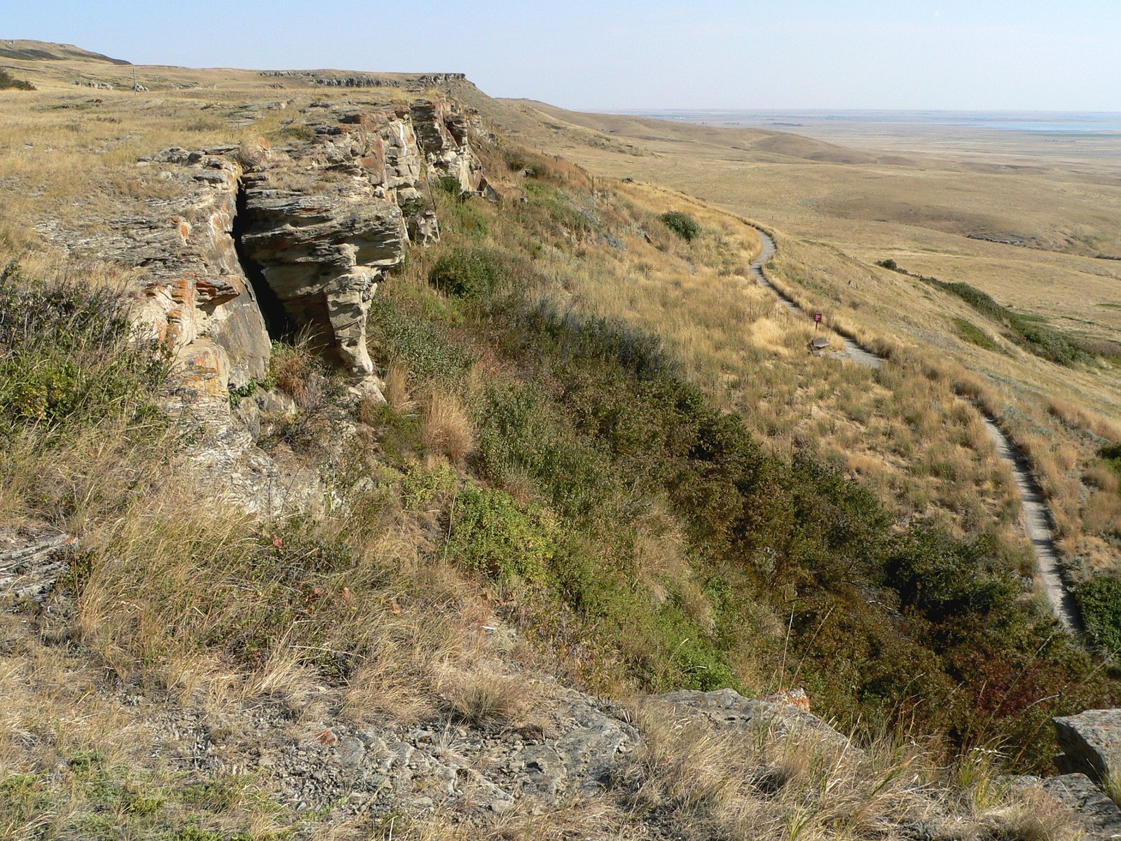
The cliff itself is a long sandstone escarpment, its face streaked red and orange, overlooking a flat sagebrush plain. From below, the scale is immediately apparent: a 10-metre vertical drop with a wide, flat killing ground at the base, now grassed over and marked by interpretive panels. The drive lanes — lines of stone cairns extending 3–4 km across the prairie to the west — are partially visible and partially reconstructed, giving a sense of the scale of pre-drive landscape management. The Interpretive Centre (1987) is built directly into the cliff face: its roof level is flush with the clifftop, and its exterior walls use local sandstone to blend with the escarpment, making the building effectively invisible from the prairie below.
Inside, seven levels of exhibits present the site's archaeology chronologically from the base deposits upward, with original artefacts, reconstructed scenes of a piskan drive, and extensive material on Blackfoot culture, oral history, and the catastrophic collapse of the bison population in the 1880s under commercial hunting pressure. The interpretive programme was developed with the direct involvement of Piikani elders and knowledge-keepers, and the centre employs Piikani staff for its guided interpretation. Excavation trenches are partially visible in the lower levels of the building, allowing visitors to see the bone-deposit stratigraphy in situ.
Practical information
- Open: Victoria Day (late May) to Labour Day (early September); reduced hours spring and fall; closed Mondays outside summer
- Entry: Fee for adults, seniors, children; combination tickets with other Alberta UNESCO sites available
- Facilities: Full interpretive centre with 7 levels of exhibits, guided tours, gift shop, film
- Nearest town: Fort Macleod, Alberta, 18 km east on Highway 785
- GPS coordinates: 49.7333° N, 113.6500° W
Getting there
Head-Smashed-In is located on Highway 785, approximately 18 km west of Fort Macleod, Alberta, and about 170 km south of Calgary. Fort Macleod is accessible via Highway 2 (the main Calgary–Lethbridge route). The nearest major airports are Lethbridge Regional Airport (approximately 60 km east) and Calgary International Airport (approximately 170 km north). A car is required; no public transport serves the site directly from Calgary or Lethbridge, though Fort Macleod has basic accommodation.
Nearby
- Fort Macleod Historic Downtown — frontier-era streetscape 18 km east, with NWMP (North-West Mounted Police) fort reconstruction
- Waterton Lakes National Park (UNESCO WHS Biosphere Reserve) — dramatic Rocky Mountain scenery on the US border, approximately 80 km southwest
- Writing-on-Stone Provincial Park (UNESCO WHS 2019) — Blackfoot rock art and badlands, approximately 90 km southeast
Sources
- Reeves, Brian O.K., Head-Smashed-In: 5500 Years of Bison Jumping in the Alberta Plains, University of Calgary, 1983
- UNESCO World Heritage Committee, Head-Smashed-In Buffalo Jump nomination evaluation, 1981
- Alberta Culture and Tourism, Head-Smashed-In Buffalo Jump Interpretive Centre, official site
- UNESCO World Heritage List: whc.unesco.org/en/list/158
Find it on the map
See this place and what’s around it →📷 Diventa un fotografo di Cultural Heritage Online
Condividi le tue foto dei luoghi: restano pubblicate con la tua firma come autore. Più vengono viste, più ti fai conoscere — e presto un concorso premierà le foto più apprezzate.
Accedi o registrati gratis per aggiungere una foto