The Sea of Cortez: The World Aquarium
The Gulf of California, known as the Sea of Cortez, was famously described by the French oceanographer Jacques Cousteau as “the world aquarium” — a term that has lost none of its accuracy despite the decades since he first applied it. Enclosed between the Baja California Peninsula and the Mexican mainland, the Gulf is a young sea formed by the tectonic separation of Baja California from the continent approximately 5 million years ago. Its geological youth, combined with the extraordinary productivity of its waters, has produced a marine environment of unparalleled biological richness. The Islands and Protected Areas of the Gulf of California were inscribed on the UNESCO World Heritage List in 2005 and extended in 2011, covering 244 islands, islets, and coastal areas along the gulf coast with a total protected marine area of approximately 700,000 hectares. The inscription recognises the site as a globally irreplaceable repository of marine and terrestrial biodiversity.
The 244 Islands: A Volcanic Archipelago
The 244 islands and islets of the Gulf of California range in scale from uninhabited volcanic rock stacks barely larger than a tennis court to substantial islands like Angel de la Guarda, which stretches over 900 square kilometres and rises to nearly 1,300 metres elevation. The islands are geologically young, formed by the same volcanic and tectonic processes that continue to shape the region today — the East Pacific Rise, the tectonic plate boundary responsible for California earthquakes, passes through the southern gulf. Each island has been isolated long enough from the mainland and from neighbouring islands to allow the independent evolution of endemic species: subspecies and full species of reptiles, birds, and even mammals that exist nowhere else. The island of Guadalupe, for example, was home to the Guadalupe caracara (now extinct due to human persecution) and continues to support the world largest winter aggregation of great white sharks at its submerged sea mounts.
Marine Megafauna: Whale Sharks, Blue Whales, and Sea Lions
The Gulf of California supports an exceptional array of marine megafauna that makes it one of the premier wildlife watching destinations in the world. Blue whales (Balaenoptera musculus), the largest animals ever to have lived on Earth, feed in the productive waters of the central and southern gulf during winter months, reaching concentrations that allow reliable sighting from whale-watching boats. Whale sharks (Rhincodon typus), the largest living fish, aggregate in the northern gulf and around La Paz Bay in enormous numbers — seasonally attracting up to 800 individuals to feed on dense patches of zooplankton and fish eggs. California sea lions (Zalophus californianus) maintain breeding colonies on dozens of gulf islands, and their high tolerance of human presence in the water makes swimming with sea lions one of the most popular ecotourism experiences in the region. Bottlenose dolphins, common dolphins, and sperm whales round out the megafauna inventory of exceptional richness.
Seabird Colonies and Island Endemism
The islands of the Gulf of California support extraordinary seabird colonies, functioning as nesting refuges for species that require isolation from mainland predators. The Midriff Islands in the central gulf host the largest breeding colonies of Heermann gull in the world — virtually the entire global population nests on Isla Rasa. Royal terns, elegant terns, brown pelicans, blue-footed boobies, and brown boobies nest on multiple islands, collectively forming one of the most significant seabird assemblages in the northeastern Pacific. Many of the islands also support endemic subspecies of land birds that have diverged from mainland populations during their isolation. The island avifauna is actively managed by Mexico National Commission of Natural Protected Areas (CONANP) through predator eradication programmes — feral cats and rats introduced by fishermen in the past have been systematically removed from several islands with measurable recovery of seabird breeding success.
Land Iguanas and Endemic Terrestrial Species
The terrestrial biodiversity of the Gulf islands is characterised by a remarkable proliferation of reptile species, many of them endemic at the species or subspecies level. The chuckwalla (Sauromalus) is represented by multiple island forms, some of which have grown to substantially larger body size than mainland relatives — an evolutionary phenomenon known as island gigantism. The spiny-tailed iguana (Ctenosaura) and the desert iguana (Dipsosaurus dorsalis) are abundant on larger islands. Several endemic rattlesnake subspecies have evolved on individual islands. The relative absence of large terrestrial predators on most gulf islands has allowed reptile populations to reach densities rarely seen on the mainland. The islands also support populations of pronghorn antelope and mule deer on some larger islands, likely stranded by rising sea levels after the last ice age and subsequently diverging from mainland populations over thousands of generations of isolation.
Conservation Challenges: Illegal Fishing and Climate Change
Despite its UNESCO status and formal protection, the Gulf of California faces severe and ongoing conservation challenges. Illegal and unreported fishing — particularly for the critically endangered totoaba (Totoaba macdonaldi), a large endemic drum fish whose swim bladder commands extraordinary prices on the Chinese black market — has devastated both the totoaba population and the vaquita porpoise (Phocoena sinus), the world smallest cetacean and most critically endangered marine mammal. Gill nets set for totoaba entangle and drown vaquita, reducing the population to fewer than 10 individuals as of recent surveys. Climate change is altering the seasonal upwelling patterns that drive the extraordinary productivity of gulf waters, with measurable effects on fish abundance and marine mammal condition. Coastal development along the Baja California peninsula and the Sonora mainland is fragmenting terrestrial habitat and introducing invasive species and light pollution to previously intact island environments.
The 2011 Extension and Protected Area Management
The original 2005 UNESCO inscription covered five island groups and five coastal protected areas. The 2011 extension significantly expanded the site to its current coverage of 244 islands and coastal zones, providing a more coherent and ecologically functional protection framework. The site is managed by Mexico through a system of Biosphere Reserves and other protected area categories under CONANP. Management plans for individual islands address threats including introduced species, illegal fishing, unregulated tourism, and human waste from recreational vessels. The UNESCO inscription has been a significant tool in attracting international conservation funding and in providing legal and political leverage against extractive interests within the protected zone. A joint management committee coordinates among the multiple agencies responsible for different components of this geographically dispersed heritage site.
Diving and Ecotourism in the Gulf
The Gulf of California offers some of the finest diving and ecotourism experiences in the world, combining marine wildlife encounters of extraordinary richness with a dramatic desert-meets-sea landscape of volcanic islands, clear turquoise water, and star-filled night skies. The towns of La Paz and Loreto on the Baja California peninsula are the primary bases for liveaboard dive operations and whale watching tours. La Paz is particularly celebrated for whale shark snorkelling between October and April, and for sea lion colony dives accessible by day boat. Loreto is the gateway for expeditions to the Loreto Bay National Marine Park, a separately managed protected area within the broader UNESCO site. The Baja California road from Ensenada to Cabo San Lucas, known as the Transpeninsular Highway, opens the full length of the peninsula to self-drive exploration, and the ferry crossing from La Paz to Mazatlan provides an alternative route for visitors combining Baja with mainland Mexico.
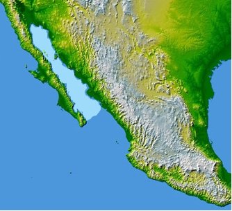
Find it on the map
See this place and what’s around it →📷 Diventa un fotografo di Cultural Heritage Online
Condividi le tue foto dei luoghi: restano pubblicate con la tua firma come autore. Più vengono viste, più ti fai conoscere — e presto un concorso premierà le foto più apprezzate.
Accedi o registrati gratis per aggiungere una foto