Gavrinis Passage Tomb
On a small island in the Gulf of Morbihan, a low cairn hides the most elaborately carved Neolithic passage tomb in Western Europe — 23 stone slabs engraved from floor to ceiling with spirals, chevrons and sinuous patterns whose meaning has been lost for five thousand years.
At a glance
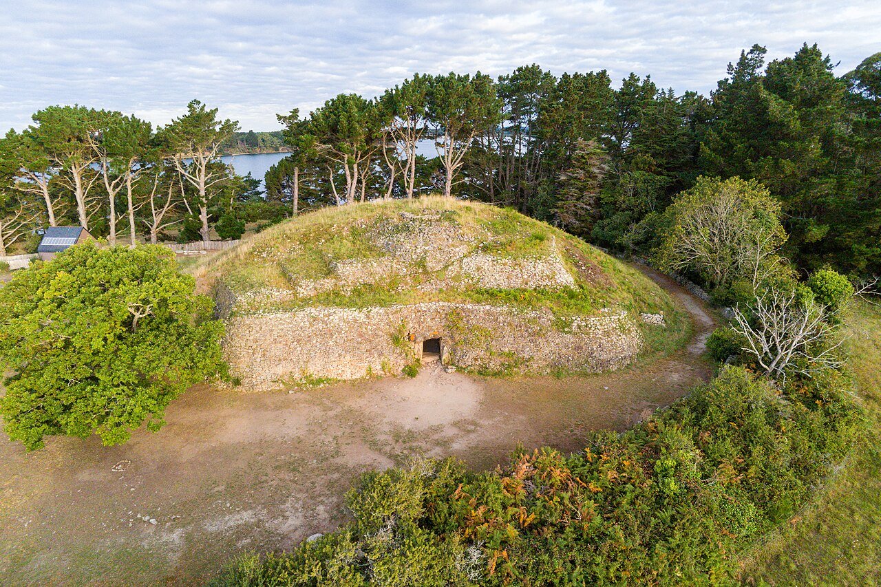
Gavrinis (from the Breton gavr enez, goat island) is a small island in the Gulf of Morbihan, reachable only by seasonal ferry from Larmor-Baden in the Morbihan department of Brittany, France. Its cairn — a roughly circular mound of dry-stone masonry about 50 metres in diameter and 6 metres high — conceals a passage tomb whose interior represents one of the supreme achievements of Neolithic art anywhere in the world. Built around 3500 BC, it is contemporary with the main Carnac monument phases and with the first construction at Stonehenge.
History and significance
The monument was built during the Middle Neolithic by communities of farmers and fisherfolk who inhabited the Morbihan coast and its offshore islands. At this period the Gulf of Morbihan was already a sacred landscape dotted with passage tombs, standing stones, and alignments — the densest concentration of megalithic monuments in the world. Gavrinis was one of the most elaborately constructed of these, and its position on an island reinforced its character as a place set apart from ordinary life.
The tomb was excavated in 1832 and has been the subject of scientific study ever since, but the most important discovery came in 1979. A granite slab removed from the roof of the burial chamber was found, on its upper face, to carry carvings that matched fragments at two nearby tombs: the Mané Rutual passage tomb and the Table des Marchands at Locmariaquer. Geochemical analysis confirmed that all three monuments had incorporated pieces of the same enormous standing stone — an er Grah-type menhir estimated to have been approximately 14 metres tall and weighing around 280 tonnes — which had been deliberately broken up around 3500 BC and its fragments distributed to consecrate three separate megalithic monuments. This great broken stone discovery revealed a level of inter-site coordination, shared mythology, and deliberate ritual transformation that was previously unsuspected for Neolithic Brittany.
The carved passage
The passage is 14 metres long and about 1.3 metres wide, lined with 29 orthostats (upright stone slabs) on both sides and covered by capstones overhead. Twenty-three of these slabs are decorated almost entirely in dense, layered abstract engraving covering the stone surface from floor to ceiling: spirals, concentric semicircles, sinuous lines, chevrons, U-shapes, axe motifs, and curvilinear forms fill every available surface. The visual effect is overwhelming — an interior seemingly alive with pattern, as if the builders intended the passage to function as an immersive symbolic environment rather than merely a corridor.
The carvings are not representational: there are no animals, no human figures, no narrative scenes. The system of signs appears to be symbolic rather than pictographic, possibly encoding cosmological, genealogical, or ritual information, but no consensus interpretation has emerged. Some researchers have identified recurring motifs — particularly the wavy line interpreted as a serpent or the shield shape — that recur at other Morbihan sites, suggesting a shared symbolic vocabulary across the megalithic communities of western Brittany.
The burial chamber at the end of the passage, roughly rectangular and roofed with a single large slab, is the part of the monument that originally contained human remains and offerings. By the time of modern excavation it had been largely cleared, but traces of cremated bone and pottery fragments were recovered.
Key facts
- Date built: c. 3500 BC (Neolithic)
- Type: Megalithic passage tomb with cairn
- Cairn dimensions: c. 50m diameter, 6m high
- Passage length: 14 metres
- Decorated orthostats: 23 of 29 slabs carved
- Access: Island — seasonal ferry only from Larmor-Baden
- Managed by: Département du Morbihan
- Related sites: Carnac alignments (20 km), Table des Marchands, Locmariaquer Grand Menhir
The great broken stone
The 1979 discovery that Gavrinis, Mané Rutual, and the Table des Marchands all incorporated fragments of a single dismembered menhir transformed understanding of the site. The original stone — known as the Grand Menhir Brisé or er Grah — now lies in four broken pieces at Locmariaquer, 4 km south-east of Gavrinis, and is the largest known standing stone ever erected in prehistoric Europe. When upright it would have been visible for many kilometres across the flat Morbihan landscape. Its deliberate destruction and distribution across multiple monuments is interpreted as a ritual act of consecration: the power or symbolism embodied in the great menhir was transferred into the fabric of the new tombs, binding together the communities that built them.
Practical information
- Access: Seasonal ferry from the port of Larmor-Baden (April–October). Crossing takes approximately 10 minutes. Booking in advance is recommended in July and August.
- Visits: Guided only — a guide accompanies every group into the passage. Maximum 20 visitors per session.
- Opening season: April to October; closed November–March
- Entry fee: Charged (combined ferry + site admission; check departmental tourism website for current rates)
- Photography: Permitted inside the passage (no flash); tripods not allowed
- Physical access: Low passage — visitors must crouch or bend at times; not suitable for those with severe mobility limitations
Getting there
Larmor-Baden is 13 km south-west of Vannes. By car: D101 from Vannes towards Baden, then south on D316. Parking at the ferry embarkation point in Larmor-Baden. By public transport: Vannes–Baden bus service (check regional timetables); the ferry port is 2 km from Baden village. The nearest large town is Vannes, served by TGV from Paris (approx. 2h30).
Nearby
- Locmariaquer (4 km): Grand Menhir Brisé, Table des Marchands, Er Grah tumulus — the site of the original great menhir whose fragments became part of Gavrinis
- Carnac (20 km): World’s largest megalithic alignment — 3,000 standing stones in parallel rows
- Vannes (13 km): Medieval walled town, Morbihan archaeological museum with outstanding collection of Neolithic artefacts from the region
- Île aux Moines (adjacent): Largest island in the Gulf of Morbihan, accessible by ferry, with dolmen and standing stones
Sources
- Wikipedia: Gavrinis
- Département du Morbihan — Official visitor information
- Cassen, S. et al. (2009): Fabrication et utilisation des stèles au Néolithique: study of the er Grah menhir fragmentation
- Sherrat, A. (1995): Instruments of conversion? The role of megaliths in the Mesolithic/Neolithic transition in northwest Europe, Oxford Journal of Archaeology
Find it on the map
See this place and what’s around it →📷 Diventa un fotografo di Cultural Heritage Online
Condividi le tue foto dei luoghi: restano pubblicate con la tua firma come autore. Più vengono viste, più ti fai conoscere — e presto un concorso premierà le foto più apprezzate.
Accedi o registrati gratis per aggiungere una fotoDo you manage this place?
This page is read by travellers and heritage enthusiasts who find it on Google. Keep it accurate — and make it work for you. Free for non-profit heritage institutions.