Chankillo
On a desert ridge in coastal Peru, thirteen stone towers built around 250 BC form the oldest known solar observatory in the Americas — a precisely calibrated instrument tracking sunrise and sunset across the full calendar year, inscribed on the UNESCO World Heritage List in 2021.
At a glance
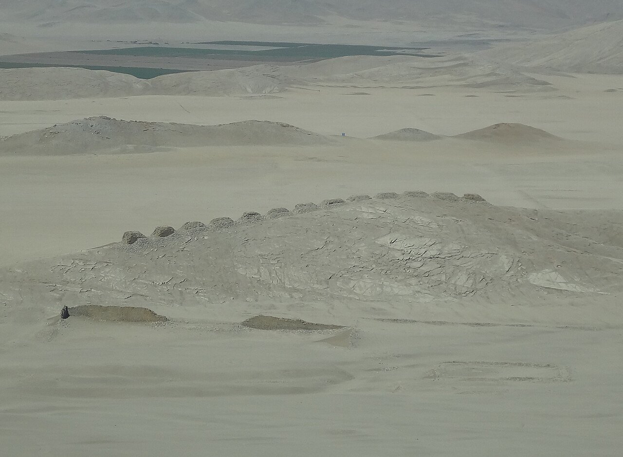
The Chankillo site sits approximately 350 km north of Lima in the Ancash department of Peru. Its defining feature — thirteen evenly spaced stone towers arranged in a north-south line along a 300-metre ridge in the Casma-Sechín Valley — constitutes the oldest known solar observatory in the Americas and one of the most ancient astronomical instruments in the world. Built by the Casma-Sechín culture around 250 BC, the towers allowed observers at two flanking posts to track the sun’s rising and setting points along the horizon across every day of the solar year, providing a calendar accurate to within two or three days. The site also encompasses a fortified ceremonial compound linking astronomical knowledge to political and religious authority. UNESCO inscribed the Chankillo Archaeoastronomical Complex on its World Heritage List in 2021.
Key facts
- Built: c. 250 BC (Casma-Sechín culture)
- Towers: 13, arranged in a 300-metre north-south ridge line
- Function: Solar observatory tracking sunrise and sunset across the full calendar year
- UNESCO WHS: Inscribed 2021 (Chankillo Archaeoastronomical Complex)
- Location: Casma-Sechín Valley, Ancash department, coastal Peru
- Distance from Lima: Approximately 350 km north via Pan-American Highway
- Associated structures: Fortified ceremonial compound, two flanking observation posts
History
The Chankillo site was built around 250 BC by the Casma-Sechín culture, one of the early complex societies of the Peruvian coastal desert. For decades after its discovery by archaeologists, the thirteen towers were interpreted as a fortification wall. The site’s astronomical function was identified only in 2007, when Ivan Ghezzi of Peru’s National Institute of Culture and Clive Ruggles of the University of Leicester published a landmark paper in Science demonstrating that the towers were a precisely engineered solar calendar instrument. Observed from two flanking posts to the east and west of the tower ridge, the movement of the sunrise and sunset along the horizon across the full year maps exactly onto the progression from the southernmost tower (summer solstice) to the northernmost (winter solstice). The thirteen towers divide this arc into approximately equal angular intervals of two to three degrees, enabling predictions of solstices, equinoxes, and agricultural calendar events to an accuracy of two or three days.
The ability to predict the solar calendar with such precision was almost certainly a power concentrated in the hands of the religious and political elite. The observatory is integrated into a larger ceremonial complex including a fortified compound with thick adobe walls and restricted internal corridors — suggesting that astronomical observations were conducted as part of controlled ritual practice. The site fell out of use after the Casma-Sechín culture declined, and its astronomical purpose was entirely forgotten until 2007. Following a decade of further excavation and research, Chankillo was inscribed on the UNESCO World Heritage List in 2021.
What you see
The thirteen towers rise between two and six metres above the desert ridge, built of stone and adobe in a remarkably regular spacing that from a distance reads as a crenellated wall — the appearance that led earlier researchers to classify them as a fortification. Each tower is slightly different in plan but the spacing between them is precisely calculated to divide the arc of the sun’s horizon movement into equal angular intervals. From the eastern observation post, the towers frame the sunrise; from the western post, the sunset. The effect — standing at an observation post at dawn on the winter solstice and watching the sun rise precisely over the southernmost tower, or at the summer solstice over the northernmost — is dramatic and immediately legible as intentional design.
The associated ceremonial compound to the southwest of the tower ridge is a multi-walled adobe structure with restricted internal corridors, plastered walls, and evidence of ritual deposit. The overall site is arid desert, with the towers standing in stark silhouette against the Andean foothills to the east and the Pacific plain to the west.
Practical information
- Open: Daily during daylight hours; site guardian present
- Admission: Small entrance fee payable on site; local guide recommended
- Best time to visit: Dawn for sunrise alignment views; June or December solstice for the full calendrical effect
- What to bring: Water and sun protection (exposed desert, no shade); sturdy footwear for uneven terrain
- Photography: Permitted throughout
Getting there
Chankillo is approximately 15 km east of the city of Casma in the Ancash department. From Lima, Casma is 350 km north along the Pan-American Highway (Ruta 1), roughly four to five hours by bus or three by private car. From Casma a dirt road leads east to the site; a 4WD vehicle or motorcycle is needed for the final approach. Guided tours depart from Casma and from Huaraz (approximately 140 km northeast). There is no public transport to the site; taxis from Casma can be arranged for a half-day excursion.
Nearby
- Sechín Alto: One of the largest adobe mound complexes in the Americas, approximately 15 km northwest of Casma (c. 1800–900 BC)
- Cerro Sechín: Major ceremonial centre with bas-relief warrior carvings, approximately 5 km from Casma town centre
- Huaraz and the Cordillera Blanca: Mountain city and trekking base approximately 140 km east, gateway to Huascarán National Park (UNESCO WHS)
Sources
- Ghezzi, Ivan, and Clive Ruggles. Chankillo: A 2300-Year-Old Solar Observatory in Coastal Peru. Science 315 (2007): 1239-1243.
- UNESCO World Heritage Centre. Chankillo Archaeoastronomical Complex. https://whc.unesco.org/en/list/1624/
- Wikipedia. Chankillo. https://en.wikipedia.org/wiki/Chankillo
Find it on the map
See this place and what’s around it →📷 Diventa un fotografo di Cultural Heritage Online
Condividi le tue foto dei luoghi: restano pubblicate con la tua firma come autore. Più vengono viste, più ti fai conoscere — e presto un concorso premierà le foto più apprezzate.
Accedi o registrati gratis per aggiungere una foto