Dasht-e Lut (sito naturale): il forno del pianeta
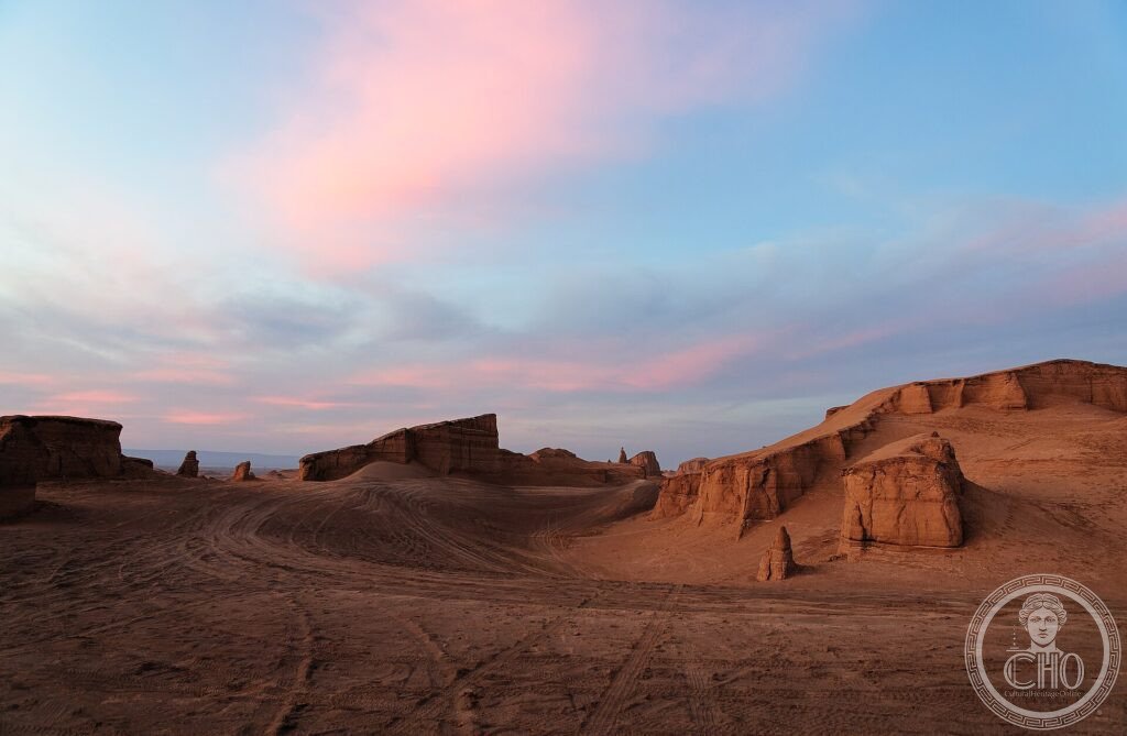
Nel sud-est dell’Iran si stende il Dasht-e Lut, uno dei deserti più estremi del mondo: qui i satelliti hanno misurato le temperature di superficie più alte mai registrate sulla Terra. Il vento ha scolpito immense creste di roccia, i kaluts, e ammassato dune giganti, creando un paesaggio di rara, aliena bellezza.
At a glance
The Dasht-e Lut, in south-eastern Iran, is one of the most extreme deserts in the world — the place where satellites have recorded some of the highest land-surface temperatures ever measured on Earth. Wind and rare water have sculpted it into spectacular landforms: vast corrugated ridges of rock and clay called kaluts (yardangs), great fields of giant dunes, and stony plains. A showcase of desert geology and an “exceptional natural laboratory”, it was inscribed by UNESCO in 2016, the first natural World Heritage site in Iran.
Key facts
- UNESCO: World Heritage since 2016 (Lut Desert), Iran’s first natural site
- Hottest land surface: some of the highest ever recorded
- Kaluts: immense wind-carved ridges (yardangs)
- Giant dunes: some of the tallest sand dunes in the world
- Desert geology: a textbook of wind and aridity
- Extreme environment: studied as an “exceptional laboratory”
History
The Dasht-e Lut owes its extraordinary forms to wind and to the long absence of rain. For thousands of years the prevailing winds have scoured a thick bed of clay and sand into the great parallel ridges and corridors of the kaluts, a “city” of natural sculptures, and built towering dunes in the desert’s eastern reaches. So hot and dry is the heart of the desert that almost nothing lives there.
Long crossed only by the hardiest travellers, the Lut became famous to scientists when satellite measurements recorded record surface temperatures over its dark, sun-baked ground. Recognised for these remarkable landforms and processes, it was inscribed by UNESCO in 2016 as the first natural site listed in Iran.
What you see
Visitors reach the desert from towns such as Kerman and Shahdad, where the famous kaluts rise from the plain like the streets and towers of a ruined city, glowing at sunrise and sunset, with the great dune fields beyond. The scale, silence and strange forms of the desert are overwhelming.
The otherworldly kaluts and the burning emptiness of the Lut are unlike anywhere else on Earth.
Practical information
- Desert: reached on tours from Kerman/Shahdad; the kaluts are the highlight
- Best time: autumn to spring; summer is lethally hot
- Time needed: a day or overnight
- Note: go with a guide; carry plenty of water
Getting there
The Dasht-e Lut is in south-eastern Iran, in Kerman province. The kaluts are usually reached from Kerman via the town of Shahdad. GPS: 30.50° N, 58.70° E.
Nearby
- Kerman — the historic desert city and gateway
- Shahdad — the oasis town near the kaluts
- Bam — the UNESCO citadel of mud, to the south
Sources
- UNESCO World Heritage Centre — “Lut Desert” (ref. 1505)
- Iranian Department of Environment — official body
- Encyclopaedia Britannica — Dasht-e Lut
Find it on the map
See this place and what’s around it →📷 Diventa un fotografo di Cultural Heritage Online
Condividi le tue foto dei luoghi: restano pubblicate con la tua firma come autore. Più vengono viste, più ti fai conoscere — e presto un concorso premierà le foto più apprezzate.
Accedi o registrati gratis per aggiungere una foto