
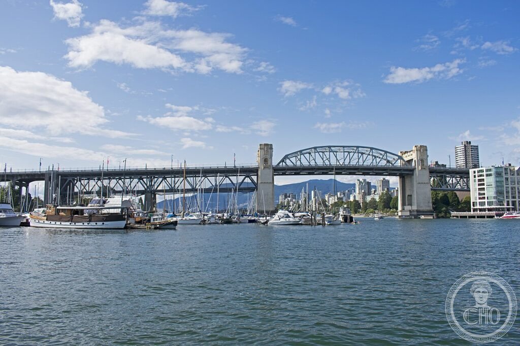

A bridge built as a city gate: concrete towers, torch-topped pylons and a steel truss hidden like plumbing — Vancouver’s crossing of 1932 is one of the only pure Art Deco bridges in the world.
At a glance
The Burrard Bridge carries Burrard Street high over False Creek, linking downtown Vancouver to Kitsilano: a five-part steel truss bridge on four piers, built 1930–1932 and opened on Dominion Day, 1 July 1932. Its engineer was Major John R. Grant; its architects, Sharp & Thompson, treated the crossing as a ceremonial gateway to the city — monumental concrete towers rise mid-span, connected by galleries that mask the steelwork, and torch-like pylons flank the approaches. Vancouver’s heritage inventory ranks it in the city’s top category.
Key facts
- Built: 1930–1932; opened 1 July 1932
- Engineer: Major John R. Grant; architects: Sharp & Thompson (George Lister Thornton Sharp)
- Structure: Five-part, four-lane steel truss bridge on four piers over False Creek
- Signature: Concrete gateway towers with connecting galleries that conceal the truss; Art Deco reliefs and lamps
- Memorial: Torch-shaped brazier pylons honour Canada’s First World War prisoners of war — Grant and Sharp were both veterans
- Heritage: Top category of the City of Vancouver’s heritage inventory
- GPS: 49.2755, −123.137 — View on Google Maps
History
By the late 1920s Vancouver’s growth had jumped False Creek, and the low, congested Kitsilano crossings could not carry it; the city resolved on a high-level bridge worthy of a main entrance. Grant engineered the spans; Sharp & Thompson — the firm behind the University of British Columbia’s first campus — clothed them. Their decision to celebrate rather than apologise for infrastructure produced the towers, the sculpted ship’s prows, and the brazier pylons: both men had served in the First World War, and they worked a memorial to Canadian prisoners of war into the fabric of a road bridge — bronze lamps shaped like the charcoal braziers PoWs had huddled around.
Opened before a crowd on Dominion Day 1932, the bridge has never stopped working — today it carries one of North America’s busiest cycling corridors beside its traffic lanes. Heritage Vancouver spent years listing it among the city’s most endangered landmarks during widening debates; the eventual upgrades kept the towers, galleries and pylons intact.
What you see
From the seawall below, the composition explains itself: a long steel truss riding four piers, interrupted mid-span by two pairs of concrete towers joined by arched galleries — a city gate hoisted into the sky. The galleries’ real job is scenographic, screening the truss so the silhouette reads as masonry; look for the sculpted ship’s prow breaking from each tower face — the twin emblems of Captain George Vancouver and Sir Harry Burrard-Neale, marked V and B. At the approaches, the freestanding pylons end in stylised torches — the PoW memorial braziers — and the original lamp standards run the deck. Walk it at sunset towards downtown: English Bay on one side, the city core rising on the other.
Practical information
- Open 24 hours to pedestrians and cyclists — separated lanes on both sides; allow 15 minutes to cross on foot
- Best views of the towers: the seawall at Vanier Park (west) or the Aquatic Centre ferry dock (east)
- Combine with the Kitsilano shoreline or a False Creek mini-ferry ride beneath the spans
Getting there
The north end rises beside Sunset Beach and the Aquatic Centre, ten minutes on foot from Yaletown–Roundhouse station; the south end lands in Kitsilano near Vanier Park. False Creek ferries cross beneath the bridge from the Aquatic Centre to Vanier Park.
Nearby
- Marine Building — Canada’s great Art Deco skyscraper, ten minutes north
- Vancouver City Hall — the Deco civic tower of 1936, across False Creek
- Vanier Park — museums and kite-flying lawns under the south approach
- Granville Island — the market district one bridge east
Sources
- Vancouver Heritage Foundation, Heritage Site Finder — “one of the only pure Art Deco bridges”, towers and pylons description
- Heritage Vancouver Society — 1930–1932 construction, heritage-inventory ranking, conservation history
- The History of Metropolitan Vancouver (vancouverhistory.ca) — Grant and Sharp, PoW memorial braziers, opening day
- Wikidata Q919808 — coordinates
Find it on the map
See this place and what’s around it →Record researched and written by Luigi De Marchi for Cultural Heritage Online, 2026.
📷 Become a Cultural Heritage Online photographer
Share your photos of places: they stay published under your name as the author. The more they're seen, the more you get noticed — and soon a contest will reward the most appreciated photos.
Log in or sign up free to add a photo