
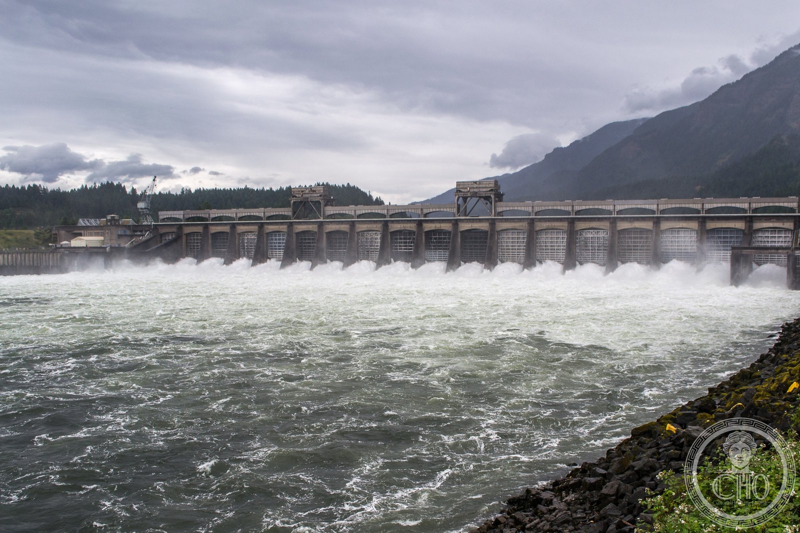
The first major federal hydroelectric dam on the Columbia River, built 1934–1937 as a New Deal flagship project — its Art Deco powerhouse buildings among the finest WPA-era civic architecture in the Pacific Northwest.
At a glance
The Bonneville Dam straddles the Columbia River at Cascade Locks, where the Columbia Gorge opens toward the Pacific coast. Completed in 1937 as a flagship project of President Roosevelt’s New Deal, the dam combines functional hydroelectric infrastructure with Art Deco architecture: the Bradford Island Powerhouse — the original generating facility — presents stepped concrete facades, geometric ornamental panels, and rhythmically grouped windows designed to give a great public works project the character of a civic monument. The whole complex was conceived as architecture, not merely engineering: it was expected to project permanence, democratic purpose, and the creative ambition of federal government.
Key facts
- Location: Columbia River, Cascade Locks, Oregon / Skamania County, Washington
- Built: 1934–1937, US Army Corps of Engineers
- Style: Art Deco / WPA Federal architecture
- Dedicated: September 28, 1937 (by President Franklin D. Roosevelt)
- Power output: Combined generating capacity over 1,000 MW
- National Historic Landmark: Yes
- Navigation lock: First major dam on the Columbia River to include a commercial navigation lock
- Visitor Center: Free admission; open year-round
History
The Bonneville Dam was authorized by Congress in 1933 as part of the first wave of New Deal public works projects. By 1934, the US Army Corps of Engineers had mobilized several thousand workers at the Columbia River Gorge site, where basalt cliffs narrowed the river between Oregon and Washington. The project combined two goals: flood control and hydroelectric power generation, which the Pacific Northwest desperately needed for industrial expansion and rural electrification. President Roosevelt dedicated the dam on September 28, 1937, calling it a symbol of what democratic government could build.
The powerhouse and ancillary structures reflect a deliberate aesthetic policy of the New Deal era. Federal architecture of the 1930s was expected to project permanence and civic pride. The Bradford Island Powerhouse — the original generating facility, located on a small island in the Columbia River — received a full Art Deco treatment: horizontal banding, stepped parapets, decorative concrete panels with geometric motifs, and large windows set in rhythmic bays. The building was not merely functional; it was designed as a monument to what collective national effort could achieve.
The dam’s opening transformed the Pacific Northwest economy. Cheap hydroelectric power attracted aluminum smelters, pulp mills, and shipyards to the Columbia Basin — industries that proved critical to the Allied war effort after 1941. The aluminum produced using Bonneville power went into aircraft frames; the shipyards it energized built Liberty ships for the Pacific theater. Additional powerhouses were added after the original, expanding the dam’s generating capacity significantly over subsequent decades. The dam has been in continuous operation ever since, one of the longest-running federal hydroelectric projects in the country.
What you see
The Bradford Island Powerhouse presents a long horizontal face toward the Columbia River, its pale concrete relieved by decorative panels, metal grillework at the ground floor, and setback upper sections that give the building the stepped profile characteristic of Art Deco institutional architecture. The windows are grouped in vertical bands, each capped with a simple concrete molding. Seen from the visitor center footbridge on the Washington side, the powerhouse reads simultaneously as a working industrial facility and as a piece of civic architecture — the decorative elements are never purely ornamental but grow from the building’s structural logic.
The navigation lock adjacent to the powerhouse is among the largest in the western United States and processes commercial barge traffic carrying grain, lumber, and other goods between Portland and Lewiston, Idaho. The fish ladders alongside the dam draw millions of salmon and steelhead each year, and the fish-viewing window in the visitor center — where visitors can watch fish passing through the ladder at eye level — remains one of the most remarkable experiences at any federal dam. The gorge landscape surrounding the dam is protected as the Columbia River Gorge National Scenic Area, and the views from both banks toward basalt cliffs and forested hillsides are among the most dramatic in the Pacific Northwest.
Practical information
- Free admission: The visitor center on the Washington side is open year-round during daylight hours, free of charge
- Dam tours: Guided tours of the powerhouse are offered seasonally; check the Army Corps of Engineers website for current schedules
- Fish viewing: The fish-viewing window is most spectacular during salmon migration season (August–October)
- Photography: Permitted throughout the public areas; tripods welcome
- Parking: Free in the visitor center lot (Washington side) and at the Cascade Locks Marine Park (Oregon side)
Getting there
From Portland, take I-84 East approximately 40 miles to Exit 44 (Cascade Locks/Bonneville) for the Oregon side, or Exit 40 (Bonneville Dam) to cross the Bridge of the Gods toll bridge into Washington for the visitor center. The drive from Portland takes about 45 minutes in light traffic. The Amtrak Empire Builder (Chicago–Seattle/Portland route) stops at Bingen-White Salmon on the Washington side, a short distance from the dam. By bus, Columbia Area Transit connects Cascade Locks to Hood River and The Dalles; connection from Portland requires a transfer at Hood River.
Nearby
- Columbia River Gorge National Scenic Area — the 292,500-acre protected area surrounds the dam complex on both sides of the river
- Multnomah Falls — the tallest waterfall in Oregon is 25 miles west on I-84; the basalt-framed drop of 620 feet is one of the most visited natural landmarks in the Pacific Northwest
- Crown Point Vista House (1917) — the Arts and Crafts/Art Deco observation rotunda on the Historic Columbia River Highway, 20 miles west
- Bridge of the Gods (1926) — the steel cantilever toll bridge at Cascade Locks crosses the Columbia at the site where, according to Native American tradition, a natural land bridge once stood
Sources
- US Army Corps of Engineers, Portland District, Bonneville Dam, nwp.usace.army.mil
- Wikipedia, “Bonneville Dam”
- National Register of Historic Places, Bonneville Dam National Historic Landmark nomination
- White, Richard, The Organic Machine: The Remaking of the Columbia River, Hill and Wang, 1995
Find it on the map
See this place and what’s around it →Record researched and written by Luigi De Marchi for Cultural Heritage Online, 2026.
📷 Become a Cultural Heritage Online photographer
Share your photos of places: they stay published under your name as the author. The more they're seen, the more you get noticed — and soon a contest will reward the most appreciated photos.
Log in or sign up free to add a photoIs this page about you?
This page is read by travellers and heritage enthusiasts who find it on Google. Tell us how you are connected to this place and we will take it from there.