
The trilingual rock inscription of Darius the Great — carved 100 metres above an ancient caravan road and deciphered by Henry Rawlinson in 1851 — unlocked the cuneiform writing system and gave historians access to 3,000 years of Mesopotamian recorded civilisation. UNESCO World Heritage Site since 2006.
At a glance
On the face of a limestone cliff approximately 100 metres above the ancient caravan road at Bisotun (also spelled Behistun), in the Kermanshah province of western Iran at the foot of the Zagros Mountains, a monumental relief and trilingual inscription commissioned by the Achaemenid Persian king Darius I (the Great, r. 522–486 BC) stands as the most important ancient inscription in the Near East. When deciphered by the British political officer Henry Rawlinson between 1835 and 1851, it unlocked the cuneiform writing system, opening to scholars all the literature, administrative records, and religious texts of the ancient Mesopotamian civilisations — approximately 3,000 years of recorded human experience that had been completely unreadable since the 4th century AD. The site was inscribed as a UNESCO World Heritage Site in 2006.
Key facts
- Location: Bisotun (Behistun), Kermanshah province, western Iran; approximately 30 km east of Kermanshah city on the ancient road between Babylonia and Media
- Date: c. 522–486 BC; commissioned by Darius I of Persia (Achaemenid Dynasty) following his seizure of the throne in 522 BC
- Scale: The carved panel measures approximately 15 × 25 metres; positioned approximately 15 metres above ground level on a cliff face approximately 100 metres high
- Languages: Three parallel cuneiform texts in Old Persian, Elamite (Susian), and Babylonian Akkadian — the trilingualism that enabled Rawlinson’s decipherment
- Content: Darius I narrates his legitimacy after the disputed succession of 522 BC, depicting himself trampling his defeated rival Gaumata and receiving the submission of 9 rebel kings, overseen by the god Ahura Mazda
- UNESCO WHS: Inscribed 2006; also contains prehistoric rock reliefs and later Parthian inscriptions on the same cliff
- Decipherment: Henry Rawlinson copied the text over multiple seasons (1835–1843) using ropes and improvised scaffolding; published the Old Persian decipherment in 1847 and the Babylonian in 1851
History
The cliff at Bisotun was already a sacred and strategic location before Darius I commissioned his inscription: the site lies on the principal route between the Babylonian heartland of the Achaemenid Empire and the Iranian plateau, and the cliff’s natural visual dominance over the road below made it ideal for a monument intended to assert royal legitimacy to everyone who passed. Darius had seized the throne in 522 BC in disputed circumstances — Cambyses II, the son of Cyrus the Great, had died on campaign in Egypt, and a claimant presenting himself as Cambyses’ brother Smerdis (whom Cambyses had secretly killed) took power briefly before Darius and six Persian nobles killed him, with Darius then defeating a series of provincial rebellions over the following year. The Bisotun inscription is Darius’s official account of these events, presented in the three principal administrative languages of the empire and positioned approximately 15 metres above ground level — deliberately inaccessible without special equipment — to prevent tampering and to assert permanence.
The inscription remained visible and partially legible in Antiquity: the Greek historian Ctesias mentioned a garden and pool at the base of the cliff, and later Parthian rulers added their own inscriptions to the same rock face. By the medieval period, the cuneiform text was unreadable, and local tradition attributed the carved panel to a supernatural or mythological origin. When Henry Rawlinson, a British officer serving as political adviser to the Persian governor of Kermanshah, began systematic study of the inscription in 1835, he worked with rope and plank platforms to copy the Old Persian text — the portion closest to the ground. The Elamite text, on a higher ledge, required still more dangerous access; a local Kurdish boy was used to reach the most inaccessible sections of the Babylonian text by driving wooden pegs into crevices. Rawlinson published his decipherment of Old Persian cuneiform in 1847 and the critical Babylonian results in 1851, the same year that Edward Hincks and Julius Oppert independently confirmed and extended his conclusions.
The consequence was the opening of an entire civilisational archive: within a generation, the administrative records of the Neo-Babylonian and Assyrian empires, the Epic of Gilgamesh, the creation myth Enuma Elish, and thousands of legal, commercial, and religious documents became readable. The Bisotun inscription was not merely important in itself; it was the key that unlocked everything else.
What you see
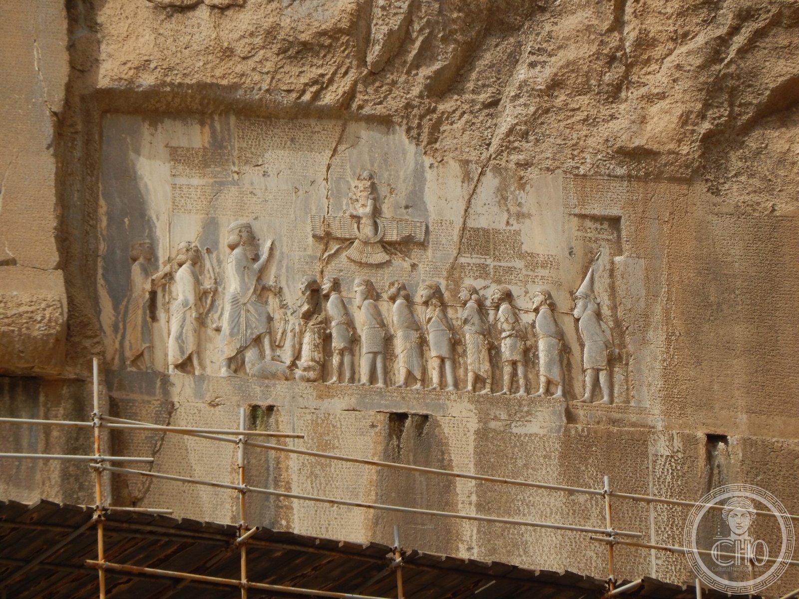
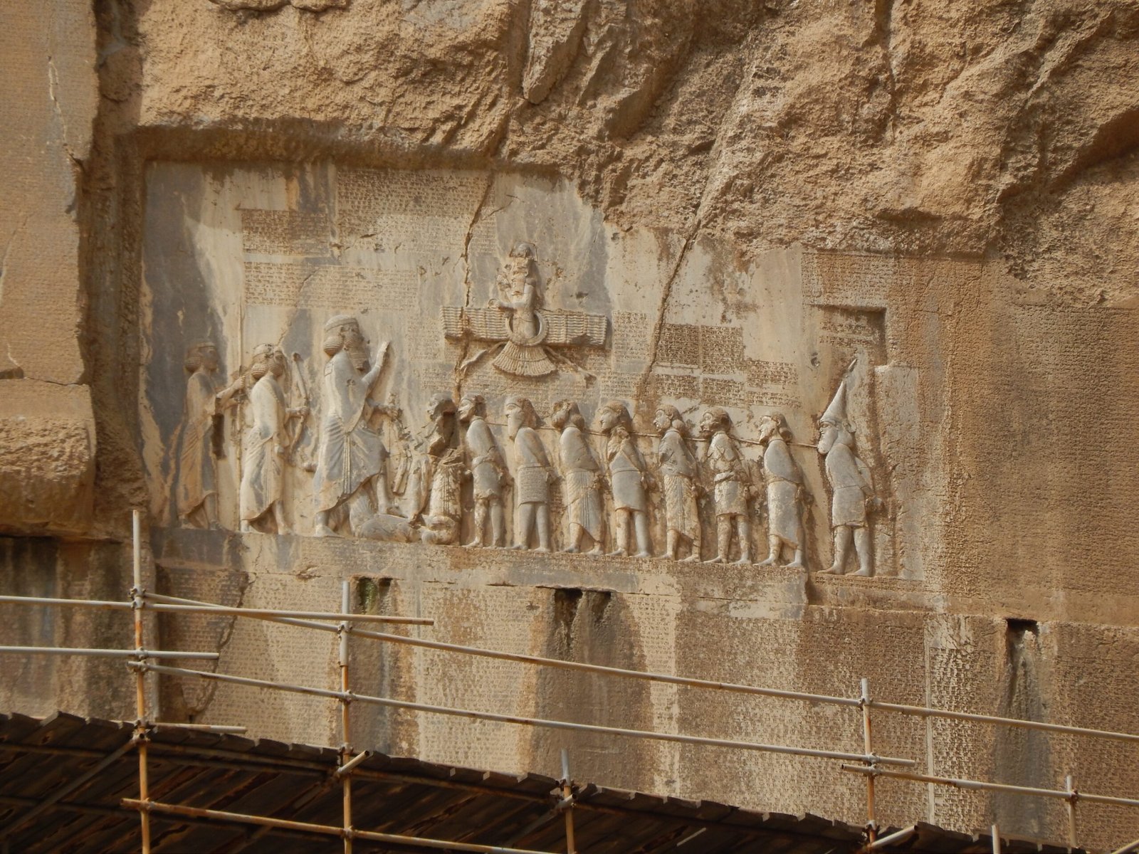
The central carved panel shows Darius I at approximately twice life-size, standing with his left foot on the body of his defeated rival Gaumata; before him, bound by a rope through their necks, stand nine rebel kings in submission; above the scene, the god Ahura Mazda floats in a winged disc (a device adopted from Egyptian iconography by the Achaemenids), extending a ring of kingship toward Darius. The figures are carved in relief in a style characteristic of Achaemenid court art — formal, frontal, hierarchically scaled — and retain traces of paint in some protected areas. The three parallel cuneiform texts (Old Persian on the left, Elamite in the centre, Babylonian on the right) cover the remaining panels of the carved area, with the Babylonian text requiring the destruction of part of an earlier relief to make room. Below the main Achaemenid panel, a later Parthian inscription (2nd century BC – 3rd century AD) records land grants, demonstrating the cliff’s continued monumental function under successive dynasties.
The site today is protected by a metal viewing platform at the base that brings visitors close to the lower portions of the cliff face, though the main inscription panel remains at a considerable height. The surrounding landscape — a flat valley floor between the Zagros foothills — gives the cliff dramatic visual presence, and the spring at the base of the cliff (the water source that made Bisotun a natural stopping point on the ancient road) is still visible. The UNESCO World Heritage designation covers not only the inscription but also the wider archaeological zone, which includes prehistoric rock engravings and ancient road infrastructure.
Practical information
- Open: Daily; the site is managed by the Iranian Cultural Heritage Organisation (ICHO); hours vary seasonally — confirm locally
- Admission: Fee applies for foreign visitors; check current rates at the site or with a local guide agency
- Best time: Spring (March–May) and autumn (September–November) when temperatures in the Kermanshah valley are mild; summer is hot, winter can be cold and wet
- Time needed: 1.5–2 hours to see the site properly, including the viewing platform and the wider archaeological zone
- Language: On-site information in Persian and English; guided tours in English available through agencies in Kermanshah
Getting there
Bisotun is approximately 30 km east of Kermanshah city on the main road toward Hamadan (Highway 48). Kermanshah has an airport with domestic flights from Tehran (approximately 1 hour) and regular bus connections from Tehran (approximately 7–8 hours). From Kermanshah, the site is accessible by taxi (approximately 30–40 minutes), shared taxi (savari), or as part of an organised tour. There is no regular public bus to Bisotun from Kermanshah. The nearest accommodation is in Kermanshah city; some travellers combine Bisotun with a visit to the ancient Sasanian relief carvings at nearby Taq-e Bostan (approximately 5 km west of Kermanshah).
Nearby
- Taq-e Bostan (approx. 35 km west, near Kermanshah city) — remarkable Sasanian royal rock reliefs of the 3rd–7th century AD, including the great arched iwan with hunting scenes of Khusrow II; among the finest Sasanian monuments in Iran
- Kangavar (approx. 40 km east) — substantial remains of a Seleucid-period temple, possibly dedicated to Anahita, on the same ancient road axis
- Hamadan (approx. 120 km northeast) — ancient Ecbatana, summer capital of the Achaemenid kings; tombs of Esther and Mordecai; the stone lion of Hamadan
Sources
- Rawlinson, Henry C. The Persian Cuneiform Inscription at Behistun. Journal of the Royal Asiatic Society, vol. 10–11, 1847–1851
- Schmitt, Rüdiger. The Bisitun Inscriptions of Darius the Great: Old Persian Text. Corpus Inscriptionum Iranicarum, 1991
- UNESCO World Heritage List: Bisotun (site 1222)
- Wikipedia: Behistun Inscription
- Brosius, Maria. The Persians: An Introduction. Routledge, 2006
Find it on the map
See this place and what’s around it →📷 Become a Cultural Heritage Online photographer
Share your photos of places: they stay published under your name as the author. The more they're seen, the more you get noticed — and soon a contest will reward the most appreciated photos.
Log in or sign up free to add a photo