
The Roman colonial capital of Dacia — established by the emperor Trajan in 106 AD after his conquest of the Dacian kingdom — was the largest city in Roman Dacia, an administrative and commercial hub that survived for approximately 170 years before the province was abandoned, and is today the most important Roman urban archaeological site in Romania.
At a glance
Beneath a shallow layer of agricultural soil in the Hațeg Basin of western Romania, the ruins of Ulpia Traiana Sarmizegetusa preserve the ground plan of a Roman colonial city established by imperial decree: a rectangular perimeter wall approximately 550 by 440 metres enclosing 32 hectares, laid out on a regular orthogonal grid, with a forum-basilica complex, an amphitheatre seating approximately 5,000 spectators, temples, baths, and private houses documented through over 500 Latin inscriptions and a century of systematic excavation. Built not on the site of the conquered Dacian capital — Sarmizegetusa Regia, 40 km to the northeast in the mountains — but on flat land at the head of the Hațeg Depression to control routes into the heart of the new province, the colonial city was the seat of the provincial governor and the main point of entry for Italian colonists, legionary veterans, and merchants from across the Roman world who transformed what had been Dacian territory into a densely populated Roman landscape within a generation of the conquest.
Key facts
- Founded: c. 106 AD by the emperor Trajan, immediately after the Roman conquest of Dacia
- Size: approximately 32 hectares enclosed within the perimeter wall; the largest Roman city in Dacia
- Population: estimated 20,000–25,000 at peak occupation (2nd century AD)
- Amphitheatre capacity: approximately 5,000 spectators; the largest Roman amphitheatre in present-day Romania
- Inscriptions: over 500 surviving Latin (and some Greek) inscriptions, the largest epigraphic corpus in Romania
- Abandoned: c. 270 AD by order of emperor Aurelian, who evacuated the entire province of Dacia
- UNESCO connection: the Dacian fortresses in the same region are UNESCO World Heritage; Ulpia Traiana is a Romanian national monument
History
The founding of Ulpia Traiana Sarmizegetusa was a direct act of imperial policy. Following two gruelling campaigns (101–102 AD and 105–106 AD) in which the Roman legions broke the power of the Dacian king Decebalus — who killed himself rather than be led in triumph through Rome — the emperor Trajan organised the conquered territory as the new province of Dacia and established a colonial capital on flat, defensible ground at the mouth of the Hațeg Basin. The choice of location was deliberate: it was not on the site of Sarmizegetusa Regia, the old Dacian sacred and royal capital in the Orăștie Mountains, but on a new site near the main military road running north from the Danube, in a position from which the governor’s administration could control the principal routes through the province. The colony was named Colonia Ulpia Traiana Augusta Dacica Sarmizegetusa — a name that appropriated the prestige of the Dacian royal capital while asserting Roman dominance — and was granted the highest status in the Roman provincial hierarchy: colonia with the ius Italicum, meaning its territory was legally treated as Italian soil and its citizens were exempt from land tax.
The city grew rapidly. Within a generation of its foundation it had the full apparatus of a Roman provincial capital: the forum-basilica complex at the centre of the grid (approximately 110 by 48 metres, among the largest forum basilicas in the Danubian provinces), the macellum (covered market), the temple of the imperial cult, baths, the amphitheatre to the east of the main grid, and the private houses and workshops of a diverse population whose origins are recorded in inscriptions: Italian veterans from Legio I Adiutrix and Legio IV Flavia Felix, traders from Asia Minor and Syria, freedmen, Gallic soldiers turned colonists, and Dacians who had adopted Roman citizenship and Latin names. The city served as the capital of the province until approximately 168 AD, when administrative reforms moved some functions to Apulum (modern Alba Iulia), though Ulpia Traiana retained its status as the senior colony. The crisis of the 3rd century — Gothic incursions, economic instability, plague — gradually drained the population; the emperor Aurelian’s decision in approximately 270 AD to formally evacuate the province of Dacia ended the city’s official existence.
After abandonment, the ruins were quarried systematically by medieval populations who used the dressed stone blocks for local construction — a process that stripped the standing remains but preserved the ground plan relatively intact beneath agricultural fields. Systematic excavation began in the 19th century under the Austro-Hungarian authorities and has continued under Romanian archaeologists; the site today is partially exposed, partially under active investigation, and contains a small on-site museum.
What you see
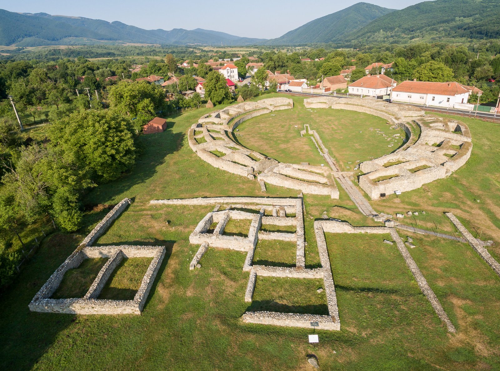
The most visible remains at Ulpia Traiana are the forum complex at the centre of the exposed area — where substantial foundations of the basilica and surrounding porticoes have been excavated and partially consolidated — and the amphitheatre to the east, whose elliptical arena and surrounding seating banks are clearly legible in both ground-level inspection and aerial photography. The amphitheatre, measuring approximately 88 by 68 metres at the outer wall, is the best-preserved major monument at the site and the largest Roman amphitheatre in Romania; its underground service corridors (hypogeum), where animals and gladiators waited before entering the arena, are partially accessible. Several stretches of the city’s principal streets are visible as low stone foundations or as cropmark alignments in dry summers.
The on-site museum and the main Deva fortress museum hold the major sculptural and epigraphic finds: figured relief panels from the forum, altar inscriptions naming provincial governors and private citizens, and votives to eastern deities brought by soldiers and traders from the Levant and Asia Minor, whose presence documents the genuinely cosmopolitan character of the colony. The surrounding Hațeg Basin gives Ulpia Traiana a landscape setting unlike most Roman sites: the ruins sit on a broad agricultural plain enclosed on three sides by the Retezat Mountains and the Poiana Ruscă range, giving the site a visual drama that the modest ground-level remains — low stone courses, open fields, a village road running along what was the main street — only hint at when set against the documented scale of the original city.
Practical information
- Address: Sat Sarmizegetusa, Comuna Sarmizegetusa, Județul Hunedoara, Romania
- Opening hours: site accessible year-round; on-site museum generally open Tuesday–Sunday 09:00–17:00, closed Mondays; confirm seasonal hours before visiting
- Admission: small entrance fee; reduced rate for students and children
- Facilities: small museum, parking area, limited refreshments in the village; no major visitor centre
- Photography: permitted throughout the open-air site; museum interiors may have restrictions
- Best season: late spring to early autumn; summer crop marks visible in dry years enhance aerial and ground reading of the grid
Getting there
Ulpia Traiana Sarmizegetusa is located in the Hațeg Basin approximately 40 km east of Deva and 60 km southwest of Hunedoara, accessible by car via the DN68 road through Hațeg town. From Deva allow approximately 50–60 minutes by car. There is no direct rail connection to the village of Sarmizegetusa; the nearest station is Hațeg, approximately 18 km away, from which local taxis or buses serve the site. Organised day tours from Cluj-Napoca (approximately 130 km north) and from Deva frequently combine Ulpia Traiana with the nearby Dacian fortresses of the Orăștie Mountains in combined itineraries.
Nearby
- Sarmizegetusa Regia (approx. 40 km northeast) — the sacred Dacian royal capital in the Orăștie Mountains, with extraordinary circular sanctuaries; a UNESCO World Heritage site distinct from Ulpia Traiana
- Hațeg Dinosaur Geopark (within the basin) — site of remarkable Late Cretaceous dwarf dinosaur fossils, including Magyarosaurus dacus
- Corvin Castle, Hunedoara (approx. 60 km northeast) — one of the largest and best-preserved Gothic-Renaissance castles in Europe
- Retezat National Park (southern edge of the basin) — glacial lakes and high-altitude wilderness beginning at the edge of the Hațeg Depression
Sources
- Ioan Piso, Inscriptions of Ulpia Traiana Sarmizegetusa, Romanian Academy, 1993 and subsequent volumes
- Hadrian Daicoviciu and Ioan Piso, Sarmizegetusa Ulpia Traiana, Archaeological Monograph Series, Bucharest, 1984
- David Breeze et al., “Ulpia Traiana Sarmizegetusa”, in The Frontiers of the Roman Empire UNESCO documentation, 2014
- Ligia Ruscu, “The Roman Colonists of Dacia and Their Origins”, Acta Musei Napocensis, Cluj-Napoca, 2003
- Wikipedia, “Ulpia Traiana Sarmizegetusa”, en.wikipedia.org (accessed 2026)
Find it on the map
See this place and what’s around it →📷 Become a Cultural Heritage Online photographer
Share your photos of places: they stay published under your name as the author. The more they're seen, the more you get noticed — and soon a contest will reward the most appreciated photos.
Log in or sign up free to add a photo