
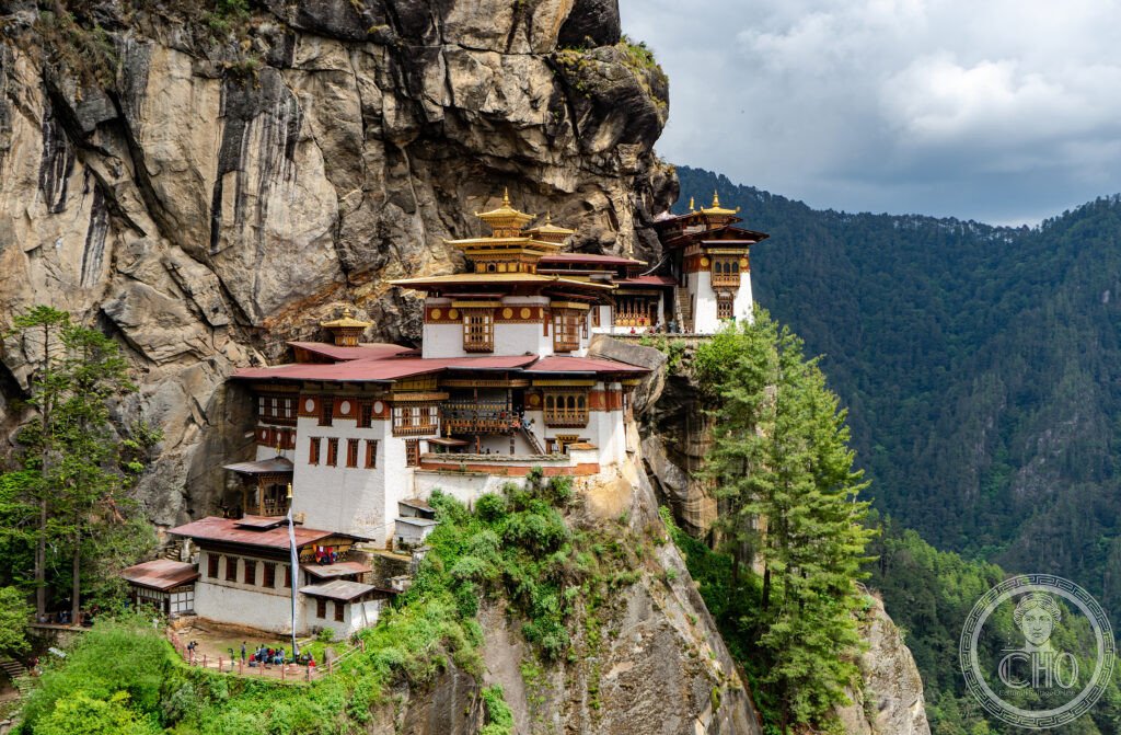
Bhutan’s most revered monastery is built onto a granite cliff 900 metres above the Paro valley, around a cave where Guru Rinpoche is said to have meditated in the eighth century after flying there on the back of a tigress. There is no road and no cable car: the only way in is a climb of some three hours, which is part of the point.
At a glance
Taktsang means Tiger’s Lair in Dzongkha. Bhutanese tradition holds that Padmasambhava — Guru Rinpoche, the Indian master credited with bringing Vajrayana Buddhism to the Himalayan kingdoms — came to this cliff carried by a tigress, the manifestation of his consort Yeshe Tsogyal, and meditated in the cave for three months. The cave became a pilgrimage site long before there was anything built around it. The monastery that now clings to the rock was constructed in 1692 by Gyalse Tenzin Rabgye, and its buildings are fitted so exactly to the ledges of the cliff that from the facing slope they seem to have grown there. It is sacred to every Buddhist school in Bhutan, and it is the image by which the country is known abroad.
Key facts
- The site: a sheer granite cliff, the monastery buildings at roughly 3,120 metres and about 900 metres above the valley floor. How seventeenth-century builders got their materials up there is still a fair question.
- The founding: the complex was built in 1692 by Gyalse Tenzin Rabgye, then Bhutan’s secular ruler, around the meditation cave at its heart.
- The 1998 fire: on 19 April 1998 fire destroyed the main temples. The restoration, directed by the Royal Government of Bhutan and completed in 2005, used traditional materials and building methods; what visitors see today is largely that rebuilding, on the original plan.
- Getting up: about three hours on foot from the car park, roughly 900 metres of ascent through blue pine forest, with a teahouse at the halfway viewpoint. The last stretch drops several hundred steps into a gorge, crosses a stream by a waterfall, and climbs the same again on the other side.
- GPS: 27.4914° N, 89.3635° E
History
The cave came first and the buildings much later. For centuries after Guru Rinpoche’s retreat, the cliff was a place of meditation retreats rather than a monastery: Tibetan and Bhutanese masters came here to sit, and the site accumulated the reputation that eventually justified building on it. Gyalse Tenzin Rabgye’s construction of 1692 gathered the caves and shrines into a single complex of temples linked by stairways and galleries cut into the rock.
The monastery has been repaired repeatedly — the position guarantees it — but the fire of April 1998 was the worst loss in its history, destroying three of the main temples along with paintings and statues that could not be replaced. The rebuilding took seven years and was carried out with traditional rammed earth, timber and craft techniques rather than modern substitutes, a decision that itself reflects how Bhutan approaches its heritage: as living religious practice first, and monument second.
What you see
The walk is the experience. The path climbs steadily through pine forest hung with prayer flags, and the monastery appears and disappears above you as the trail turns. At the teahouse, roughly level with the buildings across the gorge, you get the view that everyone photographs: the white walls and gold roofs set against grey granite, apparently unsupported.
From there the path descends a long flight of steps to a bridge over a waterfall at the bottom of the ravine, then climbs the far side to the entrance. Inside are four main temples and the meditation caves they were built to enclose, connected by narrow stairs and ledges, with the rock face itself as one wall of several shrines. Photography is not permitted inside, cameras and bags are left at the entrance, and parts of the complex remain reserved for worship.
Practical information
- Entering Bhutan: visitors other than Indian nationals need a visa and pay the Sustainable Development Fee, currently 200 US dollars per person per night, with reductions for children and exemption for the youngest. The rate has changed more than once in recent years — check the Department of Tourism’s own site before booking rather than relying on older figures.
- At the monastery: a licensed Bhutanese guide accompanies visits. Shoes come off before entering the temples, shoulders and knees stay covered, and photography stops at the door.
- The climb: five to six hours there and back at altitude; ponies can be hired for the first half of the ascent but not for the descent. Start early, carry water, and allow for the thin air if you have just arrived in the country.
Getting there
Paro has Bhutan’s only international airport, served from Delhi, Kathmandu, Bangkok and Singapore; the approach between the mountains is famously tight. The trailhead car park is about half an hour by road from Paro town. GPS: 27.4914, 89.3635.
Nearby
- Rinpung Dzong — 2 km from Paro town; the fortress-monastery of 1644 above the river, still part government offices and part monastery, reached by a covered wooden bridge.
- National Museum of Bhutan — in the round watchtower above the dzong; thangka paintings, textiles and armour, and the best introduction to what you will be looking at up the mountain.
- Thimphu — 65 km east, about an hour and a half by road; the capital, and the only one in the world without traffic lights.
Sources
- Department of Tourism, Royal Government of Bhutan — official visitor information and the Sustainable Development Fee
- Karma Phuntsho, The History of Bhutan, Random House India, 2013
- National Museum of Bhutan, Paro — collections and site history
- UNESCO World Heritage Centre — Tentative List entry for Tiger’s Nest Monastery (Taktsang), submitted by Bhutan
Find it on the map
See this place and what’s around it →📷 Become a Cultural Heritage Online photographer
Share your photos of places: they stay published under your name as the author. The more they're seen, the more you get noticed — and soon a contest will reward the most appreciated photos.
Log in or sign up free to add a photoIs this page about you?
This page is read by travellers and heritage enthusiasts who find it on Google. Tell us how you are connected to this place and we will take it from there.