Bandiagara Escarpment — Cliff Dwellings and Living Dogon Culture
A 150-kilometre sandstone cliff rising from the Sahel plain of central Mali, the Bandiagara Escarpment preserves the cliff granaries and dwellings of the Tellem people (11th–14th centuries CE) alongside living Dogon villages — their mud-brick architecture perched on the cliff face or clustered at its base — in one of the most visually extraordinary inhabited cultural landscapes in Africa.
At a glance
The Bandiagara Escarpment (Falaise de Bandiagara) is a sandstone cliff running roughly 150 kilometres in a northeast-to-southwest direction through the Sahel region of central Mali, reaching heights of up to 500 metres. The UNESCO World Heritage Site inscription (1989) recognises the area for the combination of its outstanding geological formations and the exceptional living cultural landscape of the Dogon people, whose architecture, ceremonies, and cosmological knowledge system are among the most studied and celebrated in Africa.
The earliest archaeological evidence of occupation at the cliff dates to the Toloy culture (c. 3rd century BCE – 2nd century CE), followed by the Tellem people (c. 11th–14th centuries CE), who constructed cliff-face structures — granaries and dwellings built directly into crevices and overhangs in the vertical sandstone wall at seemingly inaccessible heights — whose function and method of construction remain partially unexplained. The Dogon, arriving in the 15th century CE from the Mande region further west (according to their oral traditions), occupied the escarpment and developed a distinctive architectural tradition of flat-roofed mud-brick houses, cylindrical granaries with thatched conical roofs, and toguna (men’s meeting houses with roofs made of layers of millet stalks), all adapted to the dramatic topography of the cliff.
Key facts
- UNESCO WHS: 1989 (Cliff of Bandiagara, Land of the Dogons); criteria iv, v
- Location: Mopti Region, central Mali; approx. 600 km northeast of Bamako
- Scale: Approximately 150 km long cliff; up to 500 m high; approx. 400,000 Dogon people in the broader region
- Toloy culture: c. 3rd century BCE – 2nd century CE (earliest identified occupants)
- Tellem culture: c. 11th–14th centuries CE; cliff-face granaries and burial structures
- Dogon arrival: c. 15th century CE; still the primary inhabitants of the escarpment villages
- Archaeological excavations: Dutch-Mali joint programme (1964–ongoing) identified Tellem skeletal material and objects
- Security: Parts of the region have experienced security incidents from 2012 onward; check current travel advisories before visiting
History
The Bandiagara Escarpment has been inhabited continuously for at least two millennia, with the cliff itself providing natural defensive advantages and shelter against the desert winds of the Sahel. The Toloy people, the earliest identified occupants (c. 3rd century BCE – 2nd century CE), left circular stone structures in the upper reaches of the cliff that were discovered during 20th-century archaeological surveys.
The Tellem people (c. 11th–14th centuries CE) are most famous for their extraordinary cliff-face structures: granaries and funerary chambers built directly into the vertical sandstone wall, in some cases at heights of 30 metres or more above any natural ledge. The method by which the Tellem reached these sites — whether via rope, ladder, or some now-lost technique — remains a matter of scholarly discussion. The Tellem left behind large quantities of wooden objects, textiles, and human skeletal material in their cliff-face structures, providing one of the most significant archaeological assemblages in sub-Saharan Africa for the medieval period. Dutch archaeologist Rogier Bedaux led extensive excavations from the 1960s onward that recovered thousands of Tellem artefacts now held in Dutch and Malian museums.
The Dogon arrived in the area in the 15th century CE, displacing or absorbing the Tellem and settling the escarpment for reasons that, according to their oral traditions, included the desire to escape forced conversion to Islam and maintain their traditional religious practices. The Dogon developed the architectural and ceremonial traditions for which they are now internationally known, including the elaborate dama and sigi ceremonies connected with ancestral veneration and the passage of time. The creation of the UNESCO World Heritage Site in 1989 acknowledged both the exceptional architectural and landscape values of the escarpment and the living cultural traditions of the approximately 400,000 Dogon people who inhabit the broader region.
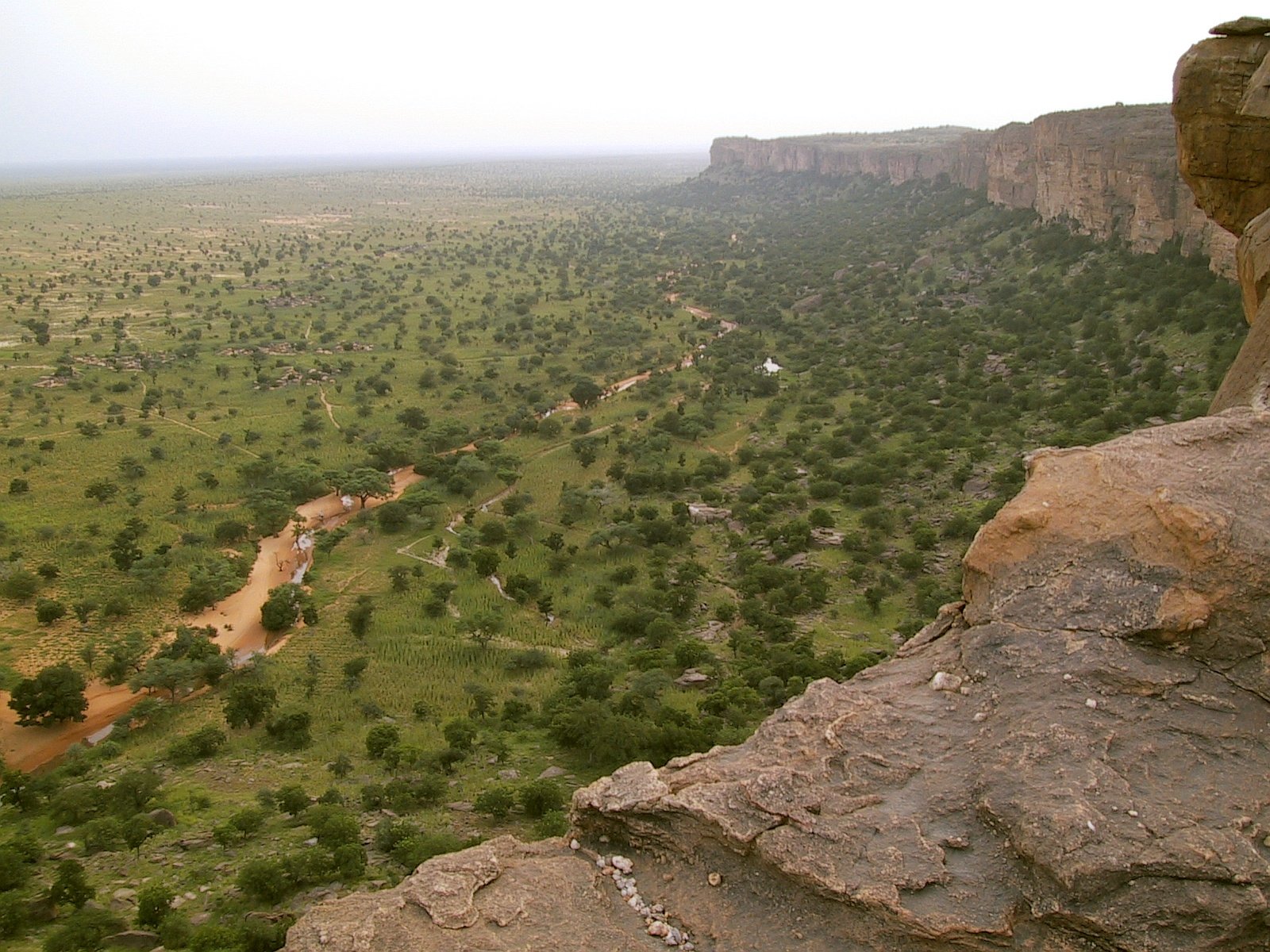
What you see
Tellem granaries. The most visually dramatic element of the Bandiagara Escarpment, these small mud-brick structures cling to the cliff face at heights that appear impossible to reach without modern climbing equipment. Dating from the 11th to the 14th century CE, they were originally used as granaries and burial chambers; some are still used by Dogon communities for storage. Their characteristic form — small rectangular or cylindrical chambers with flat or slightly domed roofs — is entirely determined by the available cliff-face space.
Dogon villages. Approximately 700 Dogon villages are distributed across the escarpment and the surrounding plain, with the most visited concentrated along a roughly 100-kilometre stretch from Sangha in the north to Djiguibombo in the south. The villages are built with mud-brick and stone architecture adapted to their positions: cliff-face villages are terraced into the rock; plateau villages cluster around central toguna structures; plain villages spread across the flat terrain below the cliff. The facades of granaries are decorated with carved reliefs of ancestral figures, animals, and geometric motifs.
Songo. A cliff-face site approximately 35 kilometres from Bandiagara town notable for its large collection of Dogon rock paintings and circumcision initiation chambers; the painted images combine abstract geometric forms with figurative representations of animals and ancestral beings.
The landscape itself. The escarpment provides one of the most spectacular natural settings in West Africa: the sheer sandstone wall, alternating between ochre, rust, and grey depending on the light, drops onto a broad sandy plain planted with millet fields and baobab trees, with the villages clustered in the transitional zone between cliff and plain.
Practical information
- Base town: Bandiagara (population approx. 15,000) is the primary gateway, with guesthouses, guides, and transport; Mopti (approx. 130 km west) is the regional hub with a wider range of accommodation.
- Access to villages: A local guide is strongly recommended and in some villages required for respectful access; the Dogon Guide Association in Bandiagara can assist. Most villages charge a small entry fee.
- Best time: October–February (cool, dry Harmattan season). Avoid April–September (extreme heat and some inaccessibility during the rainy season).
- Security: The broader Mopti Region has experienced security incidents linked to armed groups since 2012. Check your government’s current travel advisory before planning a visit.
- Permits: No formal archaeological site permit required for standard village visits; the UNESCO site fee is typically collected by village associations.
- Photography: Strict protocols apply; always ask permission before photographing ceremonies, masks, or individuals. Payment may be expected.
Getting there
The regional hub is Mopti, accessible by domestic flight from Bamako (approx. 1 hour) or by paved road (approx. 600 km, 7–8 hours). From Mopti, Bandiagara town is approximately 130 kilometres east by paved road (2–3 hours by bush taxi or private vehicle). The village of Sangha, at the north end of the most visited escarpment section, is approximately 45 kilometres from Bandiagara and accessible by rough piste that may require a 4WD vehicle in wet conditions. Most visitors rent bicycles or hire local transport in Bandiagara for access to individual villages.
Nearby
- Djenné — Historic city of the Niger Inland Delta with the world’s largest mud-brick building (Great Mosque, rebuilt 1907); UNESCO WHS 1988; approximately 200 km west of Bandiagara.
- Djenné-Djeno — Archaeological site adjacent to Djenné; the oldest known city in sub-Saharan Africa (occupied c. 250 BCE – 1400 CE), providing the archaeological context for the whole Middle Niger region.
- Mopti — The principal river port and market town of the inner Niger Delta; the convergence of the Bani and Niger rivers; a significant trading centre since at least the 14th century.
Sources
- UNESCO World Heritage: Cliff of Bandiagara (Land of the Dogons)
- Bedaux, R.M.A. & van der Waals, J.D. (1994). Djenné: Une ville millénaire au Mali. Leiden: Rijksmuseum voor Volkenkunde.
- van Beek, W.E.A. (1991). Dogon restudied: A field evaluation of the work of Marcel Griaule. Current Anthropology 32(2): 139–167.
- Wikipedia: Bandiagara Escarpment
Find it on the map
See this place and what’s around it →📷 Diventa un fotografo di Cultural Heritage Online
Condividi le tue foto dei luoghi: restano pubblicate con la tua firma come autore. Più vengono viste, più ti fai conoscere — e presto un concorso premierà le foto più apprezzate.
Accedi o registrati gratis per aggiungere una foto