Ahwar of Southern Iraq: Mesopotamian Marshes and the Cities of Sumer
The ancient marshlands at the confluence of the Tigris and Euphrates — birthplace of the world first cities, traditional home of the Marsh Arabs for 5,000 years, deliberately drained by Saddam Hussein in 1991, and partially restored since 2003. Inscribed as a UNESCO Mixed World Heritage Site in 2016.
At a Glance
The Ahwar (Arabic for marshes) of southern Iraq are one of the most extraordinary landscapes on Earth — a place where recorded human civilisation began, where urban life was first invented, and where a way of life unchanged for five millennia nearly vanished in a decade. The serial UNESCO nomination encompasses three interconnected freshwater marsh systems (Central, Huwaizah, and East Hammar marshes) in the Tigris-Euphrates delta near Basra, along with the archaeological ruins of four ancient Sumerian cities on the marsh edges: Ur, Uruk, Eridu, and Lagash. The nomination is mixed (natural and cultural) because the marshes are simultaneously a globally significant wetland biodiversity hotspot and an outstanding cultural landscape.
Key Facts
- UNESCO inscription: 2016, Mixed World Heritage Site #1481 (natural + cultural criteria)
- Location: Basra and Dhi Qar governorates, southern Iraq; Tigris-Euphrates delta
- Extent: c. 20,000 km² in full flood; currently recovered to approximately 60–70% of historic extent
- Archaeological sites included: Ur, Uruk, Eridu, and Lagash — four of the world earliest cities
- Marsh Arabs (Ma dan): Approximately 300,000 people historically; population decimated 1991–2003
- Traditional crafts: Mudhif (reed meetinghouse) construction; mashoof (wooden canoe); water buffalo herding
- Deliberate drainage: 1991–2003 CE by Saddam Hussein regime — estimated 90% drained
- Restoration: Community-led re-flooding began 2003; ongoing partial recovery
History
The Mesopotamian Marshes occupy the lower delta of the Tigris and Euphrates rivers, the same alluvial plain where the earliest agricultural communities in the ancient Near East took root around 6000–5000 BCE. The ecological productivity of the marshes — fish, waterfowl, reeds for construction, water buffalo for milk and meat — made permanent settlement not merely possible but highly attractive. By 3500–3000 BCE the settlements at the marsh edge had grown into the world first true cities: Uruk (Warka), where the first writing (cuneiform) was developed; Eridu, considered in Sumerian tradition to be the first city ever built; Ur, the city of the moon god Nanna and of Abraham in Mesopotamian religious tradition; and Lagash, a major city-state that produced some of the earliest legal texts.
The Sumerian civilisation that emerged from these settlements invented writing, monumental architecture (the ziggurat), codified law, the 60-minute hour, the wheel, and urban planning. The marshes themselves were the ecological base that fed and sustained these innovations for 3,000 years of continuous civilisation.
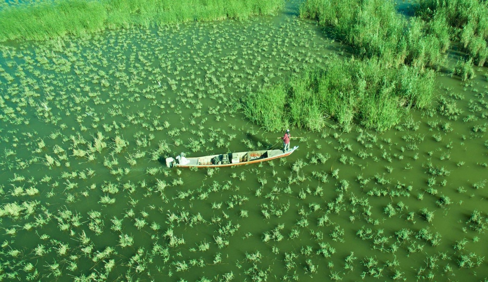
The Marsh Arabs (Ma dan) are the descendants of the people who remained in and around the marshes across all subsequent historical periods — Babylonian, Achaemenid, Seleucid, Parthian, Sassanid, Arab, Ottoman, British. Their traditional material culture — building homes, villages, and meeting halls entirely from giant reeds (Phragmites australis and Typha) without nails, metal, or mortar; navigating in low wooden canoes (mashoof); and keeping water buffalo on artificial reed islands (known as the same root that gave “floating islands” their name) — has no precise parallel anywhere else in the world and represents a living link to the Sumerian marsh-dwellers of 5,000 years ago.
In 1991, following the failed Shia uprising after the Gulf War, Saddam Hussein ordered the systematic draining of the southern marshes as a punitive measure against the Marsh Arab population who had sheltered the insurgents. A network of drainage canals, dikes, and diversions reduced the marshes from approximately 20,000 km² to less than 2,000 km² within a decade — one of the largest deliberate ecological destructions in recorded history. The Ma dan population fled or was expelled.
Following the fall of the regime in 2003, Marsh Arab communities began returning and manually breaching the drainage structures. The marshes began re-flooding almost immediately, and by 2010 approximately 50–70% of the original wetland extent had recovered. Recovery has been uneven, and the long-term hydrological balance remains fragile due to upstream dam construction in Turkey and Syria reducing the flow of both rivers.
What You See
The landscape of the Ahwar is one of reed beds, open water channels, shallow lagoons, and sky. The giant reeds (Phragmites) grow 3–5 metres tall, creating labyrinthine waterways navigable only by mashoof canoe. Flocks of migrating waterbirds — pelicans, herons, egrets, flamingos, and species not found anywhere else in the region — use the marshes as a critical stopover on the East Africa–West Asia flyway.
In the inhabited areas, the mudhif is the architectural centerpiece: a great hall constructed entirely of bundled reeds, curved into vaulted arches and sealed with woven reed matting, capable of accommodating dozens of guests. Some mudhifs are 20–30 metres long. The technique is virtually unchanged from reed-bundle architecture depicted in Sumerian stone reliefs of 2500 BCE.
At the southern edge of the marshes, the Tell of Ur (near Nasiriyah) preserves the Great Ziggurat of Ur — a massive 3-tiered platform temple constructed c. 2100 BCE under King Ur-Nammu, substantially restored in the 1980s. Eridu (Tell Abu Shahrain) preserves the earliest temple sequence in Mesopotamia, spanning 12 consecutive occupation layers from c. 5400 BCE.
Practical Information
- Security: Check current Foreign Office travel advisories before visiting; southern Iraq has improved significantly since 2010 but conditions vary
- Access to marshes: Boat tours from Chibayish or Al-Qurnah towns; local guides essential
- Ur and Eridu: Archaeological sites accessible by road from Nasiriyah (Dhi Qar Governorate)
- Time needed: 1–2 days to cover both the marsh experience and the Sumerian archaeological sites
- Best time: October–April; summers are extremely hot (40°C+)
Getting There
The gateway city for the Ahwar is Basra (airport code BSR), with connections to Baghdad and limited international flights. From Basra, road travel northwest to Chibayish (c. 120 km) gives access to the Central Marshes. The Sumerian archaeological sites (Ur, Uruk, Eridu) are reached from Nasiriyah city in Dhi Qar Governorate, approximately 370 km northwest of Basra by road, or by domestic flight to Nasiriyah where available.
Nearby
- Great Ziggurat of Ur — near Nasiriyah: best-preserved ziggurat in Iraq, c. 2100 BCE, associated with Abraham in Mesopotamian and Abrahamic tradition
- Eridu (Tell Abu Shahrain) — 25 km southwest of Ur: oldest continuous temple site in Mesopotamia, 12 occupation layers from c. 5400 BCE
- Al-Qurnah — at the confluence of the Tigris and Euphrates: traditional site identified as the biblical Garden of Eden, with a gnarled tree marking the spot
- Basra — Corniche promenade along the Shatt al-Arab waterway; Basra Museum of Antiquities
Sources
- UNESCO World Heritage List: Ahwar of Southern Iraq, Property #1481 (2016)
- Ochsenschlager, Edward L. Iraq Ancient Marshes and Modern Agriculture. University of Chicago Press, 1992.
- Wikipedia: “Mesopotamian Marshes”. Retrieved June 2026.
Find it on the map
See this place and what’s around it →📷 Diventa un fotografo di Cultural Heritage Online
Condividi le tue foto dei luoghi: restano pubblicate con la tua firma come autore. Più vengono viste, più ti fai conoscere — e presto un concorso premierà le foto più apprezzate.
Accedi o registrati gratis per aggiungere una foto