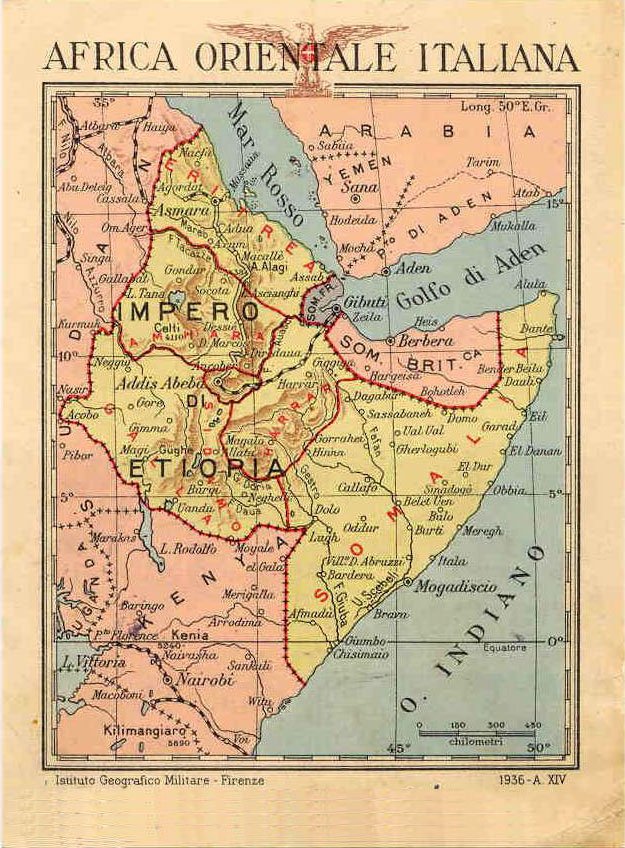
Ethiopia was the shortest-lived and most violent chapter of Italy’s overseas building. Invaded in October 1935 and proclaimed part of the empire in May 1936, it was merged with Eritrea and Somalia into Africa Orientale Italiana (Italian East Africa, AOI) — six governorates ruled from Addis Ababa. Italian control was never complete, resistance never ceased, and the whole construction ended in 1941 with the British campaign and the emperor’s return. Five years were enough, though, for an enormous programme of roads and town plans — and for atrocities that the historiography has documented in detail. Both belong to the record.
The context, stated first
In this territory more than any other, the built record must be preceded by the human one. The conquest itself was conducted, as historians including Angelo Del Boca have documented, with the use of chemical weapons against combatants and civilians. On 19 February 1937 — Yekatit 12 in the Ethiopian calendar — an attempt on the life of viceroy Rodolfo Graziani was followed by three days of massacre in Addis Ababa: a 2017 study puts the dead at around 19,200, a fifth of the city’s population. In May 1937, at the monastery of Debre Libanos, around 2,000 monks and pilgrims were executed. These are established facts of the scholarship, commemorated in Ethiopia every year. No road or master plan can be read apart from them.
The plans: an empire on paper
Italian planning for Ethiopia was vast and largely unbuilt. Addis Ababa received a master plan (by Cesare Valle and Ignazio Guidi, 1936–1938) that projected a segregated capital — a European city beside an “indigenous” one, a division that produced, among other things, the forced relocation of the main market: today’s Merkato, one of Africa’s largest open-air markets, has its origin in that segregationist decision. The most influential planner of the empire was the Florentine architect Gherardo Bosio, who in 1936–37 drew the regulatory plans of Gondar, Jimma and Dessié and published his ideas as “future cities of the empire”; he would later apply the same method in Albania. Of these plans only fragments were realised — a piazza, a post office, a cinema, offices — with Gondar holding the most recognisable Italian-era ensemble in the country.
The roads: the empire’s one great work
What the five years did produce was roads. Between 1936 and 1941 the AOI road programme built a network of about 4,400 kilometres across nine arteries — close to 5,000 counting the Eritrean works of the war’s preparation — through some of the hardest terrain in Africa. The spine was the “Via della Vittoria” from Asmara through Dessié to Addis Ababa, 1,077 kilometres. The programme consumed a workforce of tens of thousands, Italian and African, and a large share of the empire’s entire budget; economically it never repaid itself, and the war ended it. Much of today’s Ethiopian trunk network still follows those alignments — the programme’s one durable legacy.
What remains, and how to read it
The empire fell in 1941; the emperor returned; the Italian civilian presence largely dissolved in the following years. What remains on the ground is modest compared with Eritrea or Libya: the Gondar ensemble, scattered buildings in Addis Ababa, Jimma and Dire Dawa, the road alignments, and the urban footprint of decisions like the Merkato relocation. What remains in the archives is larger — the plans, the photographs, the Istituto Luce newsreels that filmed the empire for audiences at home. This archive records both, as historical sources: what was built, who designed it, when, and what happened around it. In Ethiopia’s case the last question weighs heaviest, and the record answers it plainly.
The empire on screen
One more artefact of those five years deserves note: the film record. The AOI was the most intensively filmed of Italy’s territories — the Istituto Luce sent crews with the invasion and kept them there, producing newsreels and documentaries that presented roads, plans and “civilisation” to audiences at home while omitting what the historiography would later document. UNESCO’s Memory of the World motivation for the Luce fund cites East Africa explicitly: the footage is today a primary source both on the propaganda machine and, involuntarily, on the landscapes and societies it filmed. Read against the documented record of the occupation, the smiling newsreels become evidence of a different kind — of how an empire wished to be seen, and of what it chose not to show.
Places of Italian East Africa in this archive
- Gondar — the Italian-era new centre (1936–1941, plan by Gherardo Bosio)
- Addis Ababa — the 1936–38 master plan and the relocation of the Merkato: documented in drawings and film rather than in surviving Italian monuments, so it lives in the record, not on the ground.
- Cinema Italia (Cinema Ethiopia), Addis Ababa — the former city post office rebuilt as a super-cinema in 1937, and the capital’s clearest Italian-era survivor still in use.
- Jimma and Dessié — Bosio’s plans — cards in preparation
- The “Via della Vittoria,” the 1,077 km trunk road from Asmara through Dessié to Addis Ababa — an engineering line across the highlands rather than a single monument to card.
- Asmara and Massawa — the AOI’s Eritrean bases, documented in the Eritrea piece
This is the fourth piece in the series on Italy’s overseas territories, after Libya, Eritrea and the Dodecanese.