Kujataa Greenland: Norse and Inuit Farming at the Edge of the Ice Cap
A layered cultural landscape in southwest Greenland where three separate peoples — Paleo-Eskimo hunter-gatherers, Viking Norse settlers, and modern Inuit farmers — cultivated the same strip of sub-Arctic land over 4,500 years. UNESCO World Heritage Site since 2017.
At a glance
Kujataa (meaning “the south” in Greenlandic) is an archipelago of five component areas spread across the Kujalleq municipality of southwest Greenland. Together they document a continuous, multi-cultural farming tradition from 2500 BCE to the present day — one of the world’s most extreme agricultural environments, where summer lasts barely two months and the Greenland Ice Cap looms just kilometres inland.
The landscape holds Norse farmstead ruins and turf-wall traces from the Eastern Settlement (the southernmost Norse colony in the world), Paleo-Eskimo middens and tent rings from the Saqqaq and Dorset cultures, and the still-functioning sheep farms established by Moravian missionaries around 1780 CE. It is a place where the stories of multiple civilisations are literally written into the same green hillsides.
Key facts
- UNESCO designation: World Heritage Site, 2017 (serial nomination, 5 component areas)
- Earliest occupation: c. 2500 BCE (Saqqaq Paleo-Eskimo culture)
- Norse period: c. 985 CE – c. 1408–1420 CE (Eastern Settlement)
- Modern Inuit farming: c. 1780 CE – present (Moravian-era origin)
- Key monument: Hvalsey Church (c. 1300–1408 CE) — best-preserved Norse ruin in Greenland
- Last Norse record: Wedding feast at Hvalsey, September 1408 CE
- Growing season: approximately 6–8 weeks per year
- Location: Kujalleq municipality, southwest Greenland; nearest town Qaqortoq (pop. ~3,000)
History
The Kujataa story begins with the Saqqaq culture (c. 2500–800 BCE), the first people to inhabit southwest Greenland. Saqqaq groups were maritime hunter-gatherers who ranged the coast in skin boats and left their traces — tent rings, hearths, stone tools — at dozens of sites now within the Kujataa inscription area. They were succeeded by the Dorset culture (c. 800 BCE – 200 CE), another Paleo-Eskimo people whose occupation sites partially overlap with later Norse settlements.
The Norse chapter opened in 985 CE when Erik the Red led an expedition of settlers from Iceland and established the Eastern Settlement (Eystribyggð) — the southernmost Norse outpost anywhere in the world. At its height, the Eastern Settlement comprised some 450 farms, a dozen churches, and a cathedral at Gardar (modern Igaliku). The settlers raised cattle, sheep, and goats on summer-green pastures; they traded walrus ivory and polar bear furs with Norway; and they built in turf and stone the same architectural forms they knew from Iceland and Norway. The Hvalsey Church — a roofless but intact stone hall standing at the fjordside — dates to around 1300 CE and is the best-preserved Norse building in Greenland.
The Norse Greenlanders then vanish from the written record. The last documented event was a wedding feast at Hvalsey Church in September 1408, attended by witnesses who later returned to Iceland and recorded the celebration. By 1420 CE, Norse Greenland had ceased to exist — whether through climate deterioration (the Little Ice Age cooling began c. 1300 CE), trade collapse, disease, or a combination remains debated. It is one of the great enigmas of medieval history.
The Thule Inuit, ancestors of today’s Greenlandic Inuit, began arriving from the north around the 13th century CE, sometimes occupying Norse sites after they were abandoned. Sheep farming on a settled basis resumed around 1780 CE, when Moravian missionaries and later Danish colonial authorities encouraged Inuit communities to take up the Norse agricultural tradition. That farming tradition — still active today at Qassiarsuk (ancient Brattahlið, Erik the Red’s own farm) and Igaliku — makes Kujataa unique: a living agricultural landscape directly descended from Viking-age practice.
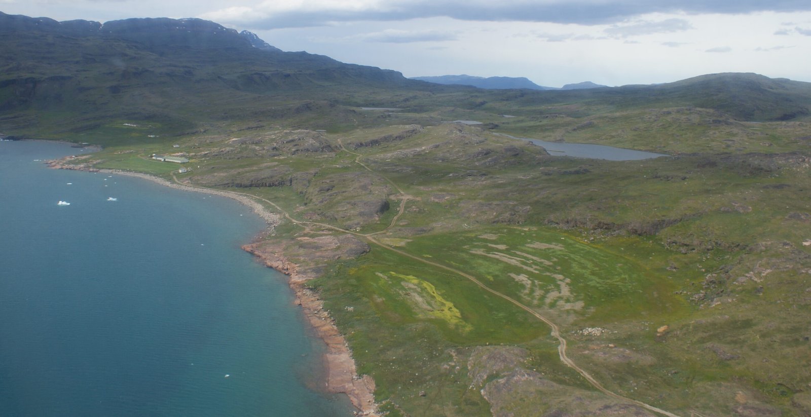
What you see
The five component areas each have a distinct character. Igaliku (Norse Gardar, the bishop’s seat) preserves the ruins of the Gardar Cathedral complex including a stone bishop’s residence and a Viking-age water management system alongside the modern Inuit village. Qassiarsuk (Norse Brattahlið) is the most visited site, with reconstructed Norse longhouses and a replica of the first Christian church in the Americas — a tiny turf chapel built by Leif Eriksson’s mother Þjóðhildr around 1000 CE.
Sissarluttoq holds extensive Norse farmstead ruins including turf-wall outlines still visible in the grass. Vatnahverfi is a peninsula with the highest concentration of Norse farm ruins in Greenland, set in rolling terrain between two fjords. Hvalsey — the most dramatic single monument — stands as a roofless stone hall roughly 16 × 8 metres, its gable ends still reaching full height, overlooking the Hvalsey Fjord in near-perfect preservation.
Throughout the landscape, the Norse turf-wall field boundaries survive as low green ridges in the meadows. Modern sheep farms still graze the same pastures that Norse Greenlanders worked a thousand years ago.
Practical information
- Season: June–September (ferry service operates; winter access by snowmobile or dogsled only)
- Base: Qaqortoq — the main town, accessible by Air Greenland from Nuuk or Narsarsuaq airstrip
- Getting around: Local ferry/speedboat services connect Qaqortoq with Qassiarsuk, Igaliku, and other component areas; no roads between settlements
- Guided tours: Available through Qaqortoq-based operators and the Narsarsuaq visitor centre
- Entry: Sites are open-access; Hvalsey Church and the Norse ruins require no ticket
- Accommodation: Guesthouses in Qaqortoq and Narsarsuaq; camping permitted in designated areas
Getting there
Greenland has no road connection to the outside world. The nearest international airport with regular connections is Copenhagen Kastrup (CPH); Air Greenland operates flights to Nuuk (the capital) and to Narsarsuaq Airport (IATA: UAK) — the closest airstrip to Kujataa, approximately 40 km north of Qaqortoq. From Narsarsuaq, boat transfers reach the individual Kujataa sites. Alternatively, Arctic cruise ships include Kujataa ports on Southern Greenland itineraries.
Nearby
- Narsarsuaq — Second World War US air base, now a village and airport; botanical garden with experimental plants; Narsarsuaq museum
- Narsaq — Small Greenlandic town with a local museum covering Norse and Inuit heritage
- Qaqortoq — Main regional centre; Greenland’s most southerly town; Stone and Man outdoor sculpture project (rock carvings by international artists across the town)
- Ice Cap access — Day hikes to the southern margin of the Greenland Ice Sheet from Narsarsuaq valley
Sources
- UNESCO World Heritage Centre — Kujataa Greenland: Norse and Inuit Farming at the Edge of the Ice Cap (whc.unesco.org/en/list/1536)
- Diamond, Jared — Collapse: How Societies Choose to Fail or Succeed (Viking, 2005) — Chapter on Norse Greenland
- Arneborg, Jette et al. — “Change of diet of the Greenland Vikings determined from stable carbon isotope analysis and 14C dating of their bones”, Radiocarbon 41/2 (1999)
- Wikipedia contributors — “Kujataa” (en.wikipedia.org)
- Greenland National Museum & Archives — online resources (natmus.gl)
Find it on the map
See this place and what’s around it →📷 Diventa un fotografo di Cultural Heritage Online
Condividi le tue foto dei luoghi: restano pubblicate con la tua firma come autore. Più vengono viste, più ti fai conoscere — e presto un concorso premierà le foto più apprezzate.
Accedi o registrati gratis per aggiungere una foto