
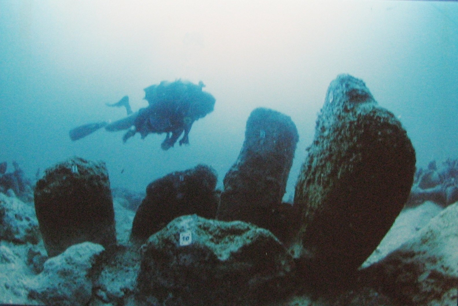
The best-preserved submerged prehistoric village in the world: a complete Neolithic fishing settlement sealed beneath 8–12 metres of water off the Israeli coast since approximately 7000 BCE, containing the world’s oldest known stone circle, the world’s oldest known engineered well, and the earliest documented clinical case of tuberculosis.
At a glance
Approximately 200–400 metres off the coast of the town of Atlit, south of Haifa on Israel’s Carmel Coast, the submerged prehistoric village of Atlit Yam lies in 8–12 metres of water — and has been studied since its discovery in 1984 by Ehud Galili of the Israel Antiquities Authority. In more than three decades of ongoing excavation, it has yielded the most complete and best-preserved prehistoric coastal settlement known anywhere in the world: an intact Neolithic fishing community of approximately 200–300 people, submerged as sea levels rose after the last Ice Age, and preserved almost perfectly by the cold, anaerobic sediment that has maintained organic materials — wood, rope, human bone, even evidence of textiles — in a state of preservation impossible in any terrestrial context of comparable age.
Key facts
- Location: 200–400 m off Atlit, Haifa District, Carmel Coast, Israel (32.6917°N, 34.9300°E)
- Depth: 8–12 metres below current sea surface
- Period: c. 6900–6300 BCE (Pre-Pottery Neolithic C)
- Settlement size: approximately 40,000 square metres; estimated population 200–300
- Discovery: 1984, Ehud Galili, Israel Antiquities Authority
- Stone circle: seven megaliths in oval form (~12 m diameter); oldest known stone monument in the world — predates Stonehenge by approximately 4,000 years
- Tuberculosis: two skeletons (adult woman and child) provide the earliest documented clinical evidence of tuberculosis anywhere in the world, c. 7,000 years ago
- UNESCO status: not inscribed, but recognised as a site of exceptional global significance
History
Around 9,000 years ago, a community of Neolithic people built a settlement at the edge of the ancient Mediterranean, on a sand platform above a freshwater spring on what was then the coastline of the Carmel Coast. They were skilled fishers and farmers: their settlement included mudbrick and stone rectangular buildings, a freshwater well (the world’s oldest known engineered water source), storage facilities, and what appears to have been a ritual installation — seven massive stone blocks arranged in an oval roughly 12 metres in diameter, whose precise purpose remains debated, though proximity to the freshwater spring has suggested associations with a water cult. They raised sheep not only for meat but for wool — the earliest known evidence of wool production — and they fished with bone hooks, nets, and dugout canoes, a complete set of which has been recovered from the seabed in extraordinary preservation.
Their submersion was gradual and inevitable. After the end of the last Ice Age, global sea levels rose steadily as continental glaciers melted, advancing across the Mediterranean at approximately 1 centimetre per year. The coastline retreated inland; the village, built at sea level, found itself first in the shallows, then beneath the waves. The process took centuries, allowing successive generations to abandon the settlement as the waters rose — which is why the site shows no catastrophic destruction layer but rather a gradual deposition of human material across the seabed. By approximately 6300 BCE the site was fully submerged, and the cold, low-oxygen conditions of the Carmel Coast sealed it effectively against the biological decomposition that destroys most prehistoric organic material.
The site was rediscovered in 1984 when Israeli marine archaeologist Ehud Galili, conducting a survey of the continental shelf for the Israel Antiquities Authority, identified the stone structures and human remains visible on the seabed. Systematic excavation began shortly afterwards and has continued across multiple seasons, producing a body of finds that has fundamentally changed the understanding of Neolithic coastal societies in the Levant — and, more broadly, of the relationship between prehistoric populations and the sea that periodically reclaims the evidence of their existence.
What you see
Diving at Atlit Yam — which requires coordination with the Israel Antiquities Authority, as the site is a protected archaeological reserve — means entering a space that is simultaneously a seabed and a village frozen in time. Stone foundations of rectangular buildings emerge from the sand, their walls still standing to a height of several courses. The oval stone circle rises from the surrounding sediment with a presence that makes its 9,000-year age difficult to fully absorb: seven stones, each roughly a metre high, arranged with deliberate precision around a central space adjacent to what was once a freshwater spring. Stone-lined storage pits, hearths, and middens of fish bone and shell extend across the site.
The water clarity on the Carmel Coast is moderate — typically 5–10 metres visibility — and the site lies at depths accessible to recreational divers (8–12 m). But Atlit Yam is not an open dive site: visits require formal archaeological permits, and the site is monitored to prevent disturbance of the fragile organic materials still in situ. The impression it leaves — of a complete neighbourhood, its streets and buildings still legible, its spiritual centre still standing — is unlike anything accessible at a terrestrial prehistoric site of the same period, where erosion and agricultural disturbance have long since erased such completeness.
Practical information
- Access: Restricted — visiting requires a research or academic permit from the Israel Antiquities Authority (www.iaa-conservation.org.il). Commercial dive tourism is not permitted at the site.
- Depth: 8–12 metres; accessible to PADI Open Water or equivalent certified divers
- Water temperature: 17–28°C seasonally (warmest July–September)
- Visibility: typically 5–10 metres; best in summer months
- Finds on display: Israel Museum, Jerusalem (selected artefacts); Hecht Museum, Haifa (University of Haifa)
- Best time to visit Haifa region: May–October for diving conditions
Getting there
Atlit is located approximately 15 km south of Haifa on Route 2 (the coastal highway). The town is served by Israel Railways (Atlit station, Coastal Line), with direct trains from Tel Aviv (c. 50 minutes) and Haifa (c. 12 minutes). By car from Tel Aviv, take Highway 2 north approximately 60 km. The site itself is offshore; contact the Israel Antiquities Authority Marine Archaeology Unit in Haifa for research access.
Nearby
- Caesarea Maritima — 20 km south; the great Herodian port city with an extensive underwater harbour
- Atlit Crusader Castle (Chateau Pelerin) — immediately adjacent; 13th-century Crusader fortress on a headland, one of the best-preserved in Israel
- Haifa and Mount Carmel — 15 km north; Bahai World Heritage gardens, Carmelite monastery, Hecht Museum
- Megiddo (Armageddon) — 35 km east; UNESCO World Heritage Bronze Age tel with 30 layers of occupation
Sources
- Galili, E. and Nir, Y. (1993). “The submerged pre-pottery Neolithic water well of Atlit-Yam, northern Israel.” Oxford Journal of Archaeology, 12(3), 315-325.
- Galili, E., Weinstein-Evron, M., and Ronen, A. (1988). “Holocene sea-level changes based on submerged archaeological sites off the northern Carmel coast in Israel.” Quaternary Research, 29(1), 36-42.
- Hershkovitz, I., et al. (2008). “Detection of tuberculosis in individuals from a Neolithic settlement in Israel.” PLOS ONE, 3(12): e3426.
- Galili, E. and Rosen, B. (2011). “Submerged prehistoric sites and landscapes on the continental shelf of Israel.” In: Benjamin, J. et al. (eds.), Submerged Prehistory. Oxbow Books.
- Wikipedia contributors. “Atlit Yam.” Wikipedia, The Free Encyclopedia. Retrieved June 2026.
Find it on the map
See this place and what’s around it →📷 Become a Cultural Heritage Online photographer
Share your photos of places: they stay published under your name as the author. The more they're seen, the more you get noticed — and soon a contest will reward the most appreciated photos.
Log in or sign up free to add a photo