Las Médulas
The largest Roman gold mine in the empire — an engineered landscape of shattered ochre cliffs created by deliberately collapsing mountains with water pressure, now a UNESCO World Heritage Site in the highlands of northwestern Spain.
At a glance
In the mountains of El Bierzo, province of León, northwestern Spain, an extraordinary landscape of red and ochre cliffs, mushroom-shaped pinnacles, and deep ravines extending across approximately 20 km² was created in the first century AD by the most ambitious mining operation in the Roman Empire. Las Médulas was the primary gold extraction site of the empire for approximately 250 years, yielding an estimated 5 million kilograms of gold. The landscape is entirely artificial — the result of a hydraulic engineering technique so destructive that no comparable human-made geological transformation exists anywhere else on Earth. UNESCO inscribed it as a World Heritage Site in 1997.
Key facts
- Location: El Bierzo, Province of León, Castilla y León, Spain (nearest village: Carucedo)
- Active mining period: c. 25 BC – c. 100 AD (approximately 250 years)
- Gold extracted: estimated 5 million kg, per ancient sources and modern estimates
- Mining method: ruina montium (hydraulic mountain collapse), described by Pliny the Elder, Naturalis Historia, c. 77 AD
- Aqueduct network: approximately 600 km of channels supplying water from the mountains
- Area: approximately 20 km² of transformed landscape
- UNESCO designation: World Heritage Site, 1997 (criteria iii, iv)
History
Roman engineers began mining operations at Las Médulas under Emperor Augustus shortly after the Cantabrian Wars concluded Roman conquest of Hispania (around 25 BC). The site was not discovered by accident — geological surveys had identified the gold-bearing quaternary deposits in the valley fill of El Bierzo, and the scale of the engineering response was deliberate from the outset. The operation was state-controlled, managed by the Imperial Roman administration, and employed an enormous workforce that ancient sources suggest numbered in the tens of thousands, drawn from the local Astur and Gallaecian populations under varying degrees of coercion.
The technique employed — ruina montium, meaning “ruin of the mountains” — was described by Pliny the Elder in his encyclopaedic Naturalis Historia (c. 77 AD). Pliny had served as a naval officer and administrator in Hispania Tarraconensis during the reign of Vespasian and may have witnessed the operation directly. His description is precise: water was channelled from distant mountain sources through a network of aqueducts totalling approximately 600 km in length, stored in large cisterns cut into the hillsides above the mining area, and then released simultaneously through tunnels that had been excavated beneath the mountain. The weight of the water pressure, released suddenly into the prepared void, collapsed the mountain from below, washing the debris downhill where it was processed through wooden troughs to separate the gold particles from the silt. The technique was repeated across successive sections of the mountain range over two and a half centuries, producing the geological landscape visible today.
Mining operations declined sharply in the late first century AD — probably when the richest and most accessible gold-bearing strata had been exhausted — and appear to have ceased entirely by the reign of Trajan (98–117 AD). The site was subsequently abandoned, the forests began a partial recovery, and the transformed landscape became part of the agricultural and pastoral economy of medieval León. UNESCO inscription in 1997 followed decades of archaeological surveys that confirmed the scale and method of the Roman operation.
What you see today
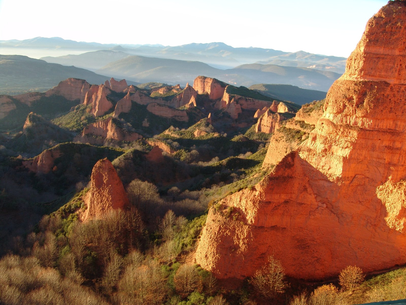
The landscape of Las Médulas is unlike anything else in Europe. The dominant visual impression is of vivid colour: the exposed rock and soil are a deep orange-red to ochre, created by the iron-oxide-rich quaternary sediments that were mined for gold. From the main viewpoints (particularly the Mirador de Orellán, reached by footpath), the panorama extends across a maze of cliff faces, isolated pinnacles — the most characteristic feature of the landscape — and winding gullies. The pinnacles are the sections of mountain that were not undermined during the Roman operation; everything between them was deliberately collapsed and washed away. The cave-like openings visible at the base of some cliff faces are the surviving entrances to the Roman tunnels through which water was driven underground before release.
On the hillsides surrounding the mining area, the Roman aqueducts survive as contour-following terraces — often mistaken for natural geological features but in fact the precisely engineered water-delivery channels that supplied the operation. Several sections are accessible on foot. Within the UNESCO-protected zone, the landscape is largely undeveloped: a visitor centre operates in the village of Las Médulas, trails lead to multiple viewpoints and into the mining area itself, and a section of the Roman aqueduct channels can be followed on foot. The site is also notable for the preservation of mature chestnut forests in the lower areas, planted by medieval settlers and still harvested today, which give the landscape a second layer of seasonal colour in autumn.
Practical information
- Visitor centre: Las Médulas village; open Tuesday–Sunday; free or low-cost entry
- Best viewpoint: Mirador de Orellán — 20-minute uphill walk from parking; most photographed panorama
- On-site trails: marked trails through the mining zone and along Roman aqueduct sections; allow 2–4 hours
- Best season: spring and autumn; summer can be very hot; late October for chestnut colour
- Photography: outstanding at golden hour; dawn light from Orellán is world-class
Getting there
Las Médulas is located approximately 21 km west of Ponferrada in the province of León, reached via the A-6 motorway (Ponferrada exit) and then local roads toward Carucedo and Las Médulas village. There is no direct public transport; a car or organised tour from Ponferrada is necessary. Ponferrada is served by trains from Madrid (approximately 4 hours) and León (approximately 1.5 hours). From Ponferrada, taxis and local tour operators offer day trips to Las Médulas. The site lies 3 km south of Carucedo village on a paved road with parking areas near the visitor centre and trailheads.
Nearby
- Ponferrada — 21 km east; medieval Templar castle, capital of El Bierzo
- Lago de Carucedo — adjacent; lake formed by collapse of Roman mine tailings, visitable on foot
- Villafranca del Bierzo — 30 km north; pilgrim town on the Camino de Santiago, Romanesque churches
- Castro de la Ventosa — 25 km northeast; Iron Age Castro culture hillfort, pre-Roman predecessor to Ponferrada
Sources
- Pliny the Elder, Naturalis Historia, Book XXXIII, paragraphs 66–78 (c. 77 AD) — primary ancient description of ruina montium
- Sanchez-Palencia, F.J. et al., “Las Médulas (León): An Engineered Landscape of the Roman Gold Mining in the Northwest of Hispania,” Geoarchaeology (2006)
- UNESCO World Heritage List, Las Médulas (1997) — nomination dossier and criteria statement
- Domergue, Claude, Les mines de la Péninsule Ibérique dans l’antiquité romaine, Publications de la Casa de Velázquez, 1990
- Wikipedia, “Las Médulas” — consulted June 2026
Find it on the map
See this place and what’s around it →📷 Diventa un fotografo di Cultural Heritage Online
Condividi le tue foto dei luoghi: restano pubblicate con la tua firma come autore. Più vengono viste, più ti fai conoscere — e presto un concorso premierà le foto più apprezzate.
Accedi o registrati gratis per aggiungere una foto