Sutkagen-dor
The westernmost city of the Indus Valley Civilisation — a substantial Bronze Age urban centre on the Makran coast, once probably a port of call on the sea route from the Indus to Mesopotamia, now stranded deep in the Balochistan desert, one of the most remote archaeological sites in the world.
At a glance
On the Makran coast of Balochistan in Pakistan, approximately 480 km west of Karachi and less than 60 km from the modern Iranian border, the ruins of Sutkagen-dor mark the westernmost known city of the Indus Valley Civilisation. At the height of the Harappan period (c. 2600–1900 BC), Sutkagen-dor was a substantial urban centre of approximately 5 hectares with a fortified citadel, a lower town, and probable harbour facilities — an outpost on the sea route between the great Indus cities and the markets of Mesopotamia. Sea levels along the Makran have dropped since the Bronze Age, and the site (now approximately 50 km inland) would have sat at or near the coast in Harappan times. Today it lies in a tribal area of Balochistan accessible only by 4WD with security coordination, making it among the least-studied major Bronze Age sites in the world.
Key facts
- Status: Westernmost known city of the Indus Valley (Harappan) Civilisation
- Period: c. 2600–1900 BC (Mature Harappan phase)
- Scale: Approximately 5 hectares; fortified citadel mound 145 × 95 metres of mudbrick construction
- Function: Probable coastal port of call on the sea route between the Indus Valley and Mesopotamia
- Geography change: Now ~50 km inland; in Harappan times, sea levels were higher and the site was at or near the Makran coast
- Archaeological history: Surveyed by Aurel Stein (1928); partially excavated by George Dales, University of Pennsylvania (1960, 1962); no systematic excavation since
- Access: Extreme — tribal area of Balochistan; requires 4WD and security coordination
History
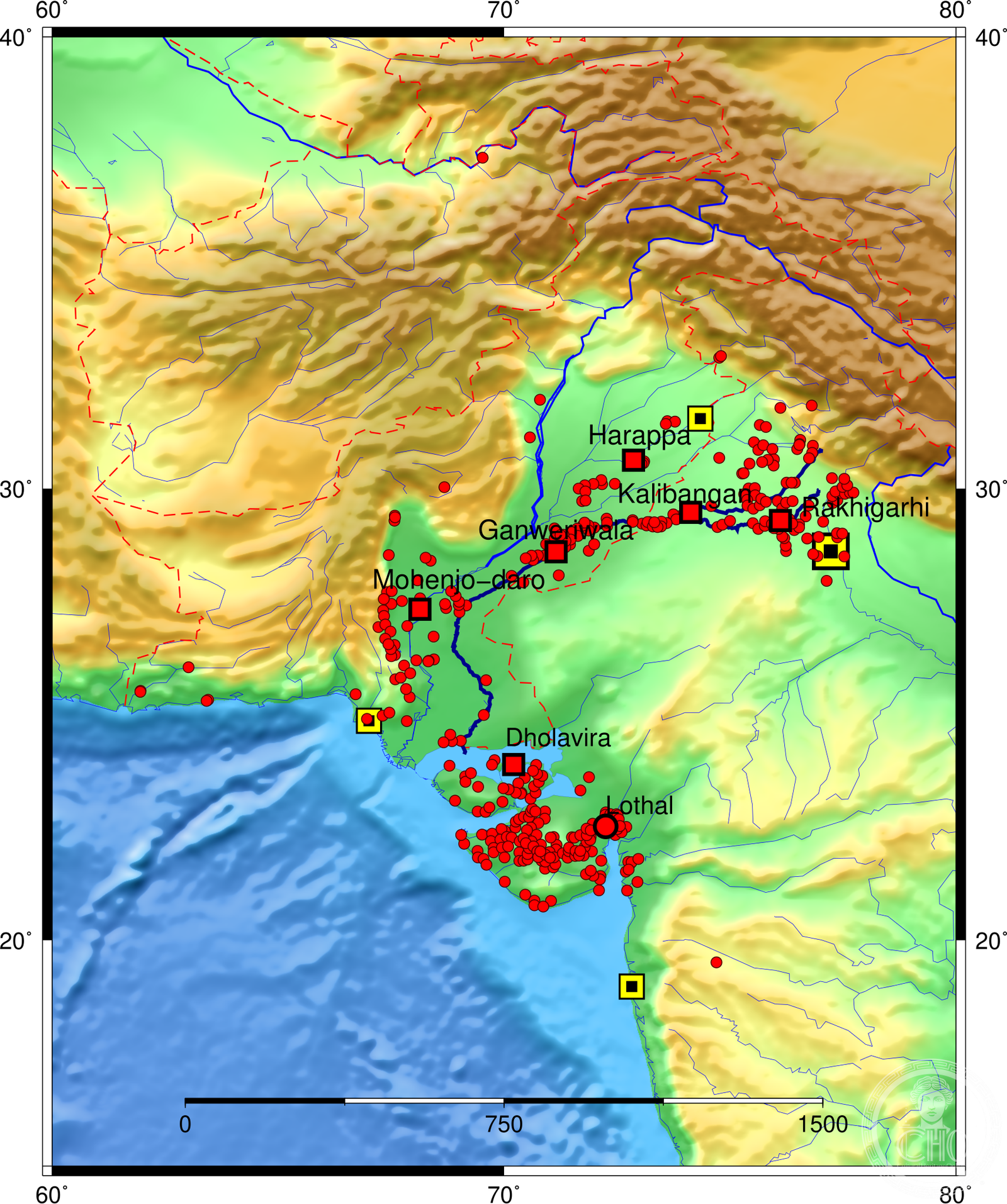
Sutkagen-dor was built during the Mature Harappan phase of the Indus Valley Civilisation, the extraordinary Bronze Age urban culture that flourished across what is now Pakistan, northwestern India, and parts of Afghanistan between approximately 2600 and 1900 BC. At its maximum extent, the Harappan civilisation covered approximately 1.25 million square kilometres — the largest Bronze Age civilisation in area in the world, significantly exceeding the contemporary civilisations of Egypt and Mesopotamia in spatial reach. The major Harappan cities — Mohenjo-daro, Harappa, Ganweriwala, Rakhigarhi — were substantial urban centres with sophisticated drainage systems, standardised weights and measures, and a script that remains undeciphered. Sutkagen-dor was the farthest reach of this network toward the west.
The sites probable function was as a maritime waystation: a port and supply point on the coastal route that connected the Indus Valley heartland with the Persian Gulf and ultimately with the cities of Mesopotamia. Harappan merchants and their goods — carnelian beads, lapis lazuli, ivory, cotton textiles — are documented in contemporary Mesopotamian records and in the archaeological record of Bahrain (ancient Dilmun) and Oman (ancient Magan). Sutkagen-dor, with its citadel and probable harbour, was positioned to serve this trade. The Makran coast route is treacherous but navigable, and the placement of Harappan sites along it (Sutkagen-dor being the westernmost) strongly suggests organised coastal logistics.
The site was first recorded by the British archaeologist and explorer Aurel Stein during his survey of Balochistan in 1928, and partially excavated by George Dales of the University of Pennsylvania in two seasons (1960 and 1962). No systematic excavation has taken place since, partly due to the sites extreme remoteness and partly due to security conditions in Balochistan that have restricted access to foreign archaeologists since the 1970s. The site remains substantially unexcavated, and its full extent and character are unknown.
What you see
The most prominent visible feature of Sutkagen-dor is the fortified citadel mound: an elevated rectangular platform of mudbrick construction approximately 145 × 95 metres, rising above the surrounding desert plain. Mudbrick construction of this scale and regularity is characteristic of Harappan civic architecture. The citadel platform would have housed administrative, religious, and elite residential functions — the standard Harappan layout divides a city into an elevated citadel (west) and a lower residential town (east). At Sutkagen-dor, the lower town extends to the south and east of the citadel, partially visible as surface mounding.
The Makran landscape that surrounds the site is one of the most arid and dramatic in Asia: a semi-desert coastal plain backed by the Makran Coastal Range, dry riverbeds (nallahs) cutting through eroded mudstone hills, and a near-complete absence of permanent settlement. The absence of post-Harappan occupation has actually been beneficial for the sites preservation — unlike many Harappan sites that were built over or quarried for brick, Sutkagen-dors remoteness has kept it largely undisturbed by later activity.
Practical information
- Access: Extreme remote — tribal area of southern Balochistan; 4WD essential, security coordination required, advance clearance from local authorities strongly advised
- Nearest town: Turbat (Kech district), approximately 100 km east; basic facilities only
- No visitor facilities: The site has no infrastructure of any kind — no signage, no fencing, no interpretation
- Research access: Foreign researchers require formal clearance from the Government of Pakistan (Department of Archaeology and Museums) in addition to security arrangements
- Best time: October–March; summer temperatures in the Makran regularly exceed 45°C
Getting there
Sutkagen-dor is located in the Kech district of Balochistan, approximately 480 km west of Karachi. The nearest airport with regular service is Turbat Airport (TUK), connected by PIA flights from Karachi. From Turbat, the site requires 4WD travel across the Makran terrain on routes that are not marked on standard navigation maps. The site lies in an area that has historically required security coordination and permissions from local authorities and the Balochistan government. Given these conditions, Sutkagen-dor is effectively inaccessible for independent tourism; the only realistic visits are by researchers or journalists with full local logistical support arranged in advance.
Nearby
- Mohenjo-daro — the largest excavated city of the Indus Valley Civilisation and a UNESCO World Heritage Site, approximately 800 km northeast; the definitive reference point for Harappan urbanism
- Mehrgarh — in the Kachi plain of Balochistan, one of the earliest agricultural settlements in South Asia (c. 7000 BC), predating the Harappan civilisation and showing the cultural continuum from which it emerged
- Ormara — fishing town on the Makran coast, approximately 200 km east; the nearest coastal settlement to Sutkagen-dor with basic tourist facilities
Sources
- Stein, M. Aurel, An Archaeological Tour in Gedrosia, Memoirs of the Archaeological Survey of India No. 43, Calcutta, 1931
- Dales, George F., “Harappan Outposts on the Makran Coast”, Antiquity 36 (1962): 86–92
- Kenoyer, Jonathan Mark, Ancient Cities of the Indus Valley Civilisation, Oxford University Press and American Institute of Pakistan Studies, 1998
- Possehl, Gregory L., The Indus Civilisation: A Contemporary Perspective, AltaMira Press, 2002
- Parpola, Asko, The Roots of Hinduism: The Early Aryans and the Indus Civilization, Oxford University Press, 2015
Find it on the map
See this place and what’s around it →📷 Diventa un fotografo di Cultural Heritage Online
Condividi le tue foto dei luoghi: restano pubblicate con la tua firma come autore. Più vengono viste, più ti fai conoscere — e presto un concorso premierà le foto più apprezzate.
Accedi o registrati gratis per aggiungere una foto