Mare di Wadden (sito naturale): la più grande distesa di fondali intertidali d’Europa
Tra la costa continentale nord-europea e le Isole Frisoni si estende uno dei paesaggi naturali più spettacolari e meno noti d’Europa: il Mare di Wadden, una vastissima zona intidale di bassifondi, pianure di fango, saline e canali che si svuota due volte al giorno con le maree. Habitat critico per milioni di uccelli migratori dell’intera rotta atlantica europea, e nursery per le specie marine del Mare del Nord, è Patrimonio UNESCO dal 2009, esteso a Danimarca nel 2014.
At a glance
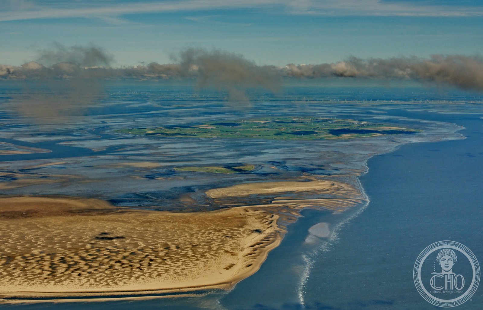
The Wadden Sea is the world’s largest unbroken system of intertidal sand and mudflats, stretching 500 km along the coast of the Netherlands, Germany and Denmark. An area of around 10,000 km² is exposed at low tide, revealing an extraordinary landscape of tidal channels, mudflats, sandflats, salt marshes and dunes. The site is one of the most important wetlands on Earth: a feeding and resting ground for up to 12 million migratory birds annually, and a key nursery for commercially important fish species. UNESCO inscribed the Dutch and German parts in 2009, extended to include Denmark in 2014.
Key facts
- UNESCO: World Heritage since 2009 (NL+DE); extended to Denmark 2014 (ref. 1314ter)
- Area: approx. 10,000 km² of intertidal zone across three countries
- Birds: up to 12 million migratory birds rest and feed here each year
- Fish: key nursery for plaice, sole, herring and many North Sea species
- Tides: exposed twice daily at low tide, creating vast visible mudflat landscapes
- Seals: harbour and grey seals breed on the sandbanks
History
The Wadden Sea has been shaped over thousands of years by the interaction of rivers, sea currents and tidal forces. Human settlement of the coast dates back at least 2,000 years, and the region has a complex history of land reclamation, dyke-building and flooding — storms have repeatedly inundated settlements, most catastrophically in the 13th-century floods that created the Zuiderzee (now the IJsselmeer) and isolated the Frisian islands. For centuries, people walked across the exposed mudflats at low tide to reach the islands, a practice called Wadlopen (mudflat hiking) still popular today.
Recognition of the Wadden Sea’s exceptional ecological value grew during the 20th century. The area was protected by national parks in the Netherlands (1982), Germany (1985) and Denmark (1982) before the trilateral UNESCO nomination, which required coordinated international conservation management. Since inscription, tidal flat areas previously reclaimed for agriculture have been restored to natural wetland in some sections.
What you see
At low tide the Wadden Sea becomes a landscape of extraordinary flatness and silence: miles of ribbed, glistening mudflats, tidal channels draining into the sea, flocks of dunlins and oystercatchers, and the smell of salt and exposed sediment. At high tide the same landscape disappears under a shallow sea dotted with the dunes of the Frisian islands. Walking across the mudflats with a guide from the mainland to one of the islands is one of the most distinctive experiences in northern Europe.
The salt marshes along the inner coasts are rich in sea lavender and samphire in summer; harbour seals haul out on the sandbanks; spoonbills nest in the dunes. The flat horizons and vast skies give the landscape an otherworldly quality.
Practical information
- Access: ferries to the Frisian islands (Sylt, Föhr, Pellworm in Germany; Texel, Vlieland, Terschelling in NL)
- Mudflat walking: guided Wadlopen excursions from the coast (always with a guide; dangerous without)
- Best time: May–September; spring for bird migration; summer for seals and seal-pups
- Visitor centres: at Wilhelmshaven (Germany) and Den Helder (Netherlands)
Getting there
The Wadden Sea coast is accessible from Hamburg, Bremen and Groningen. Ferries to the German islands depart from Dagebüll, Nordstrand and other mainland ports. Ferries to the Dutch islands depart from Den Helder and Harlingen. GPS (German section): 53.53° N, 8.56° E.
Nearby
- Sylt — Germany’s fashionable North Sea island, known for its beaches and dunes
- Texel — the largest Dutch Frisian island, with beaches, dunes and a seal rehabilitation centre
- Hamburg — the great port city 120 km from the German Wadden Sea coast
Sources
- UNESCO World Heritage Centre — “Wadden Sea” (ref. 1314ter)
- Common Wadden Sea Secretariat (CWSS) — trilateral conservation body
- Encyclopaedia Britannica — Wadden Sea
Find it on the map
See this place and what’s around it →📷 Diventa un fotografo di Cultural Heritage Online
Condividi le tue foto dei luoghi: restano pubblicate con la tua firma come autore. Più vengono viste, più ti fai conoscere — e presto un concorso premierà le foto più apprezzate.
Accedi o registrati gratis per aggiungere una foto