

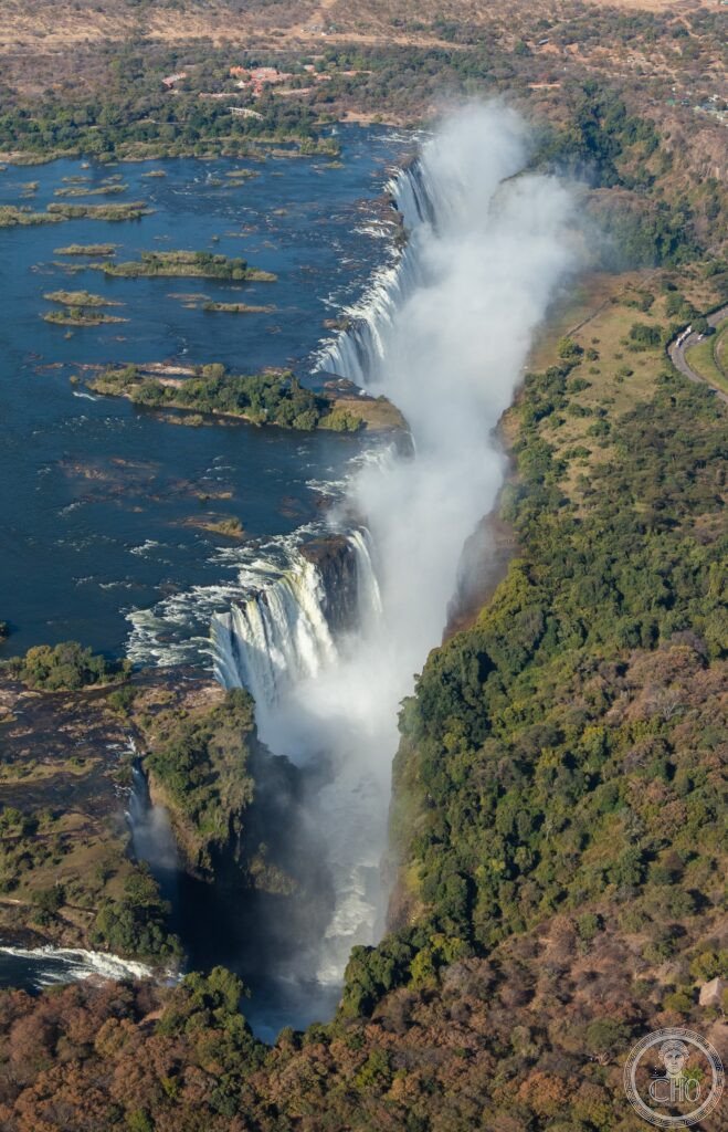
The Zambezi River falls 108 metres over a width of 1,708 metres into a fractured basalt gorge, making Victoria Falls the largest single sheet of falling water on Earth. Locally called Mosi-oa-Tunya, ‘the smoke that thunders’, it throws up a spray cloud visible for kilometres and, on full-moon nights, a rare lunar rainbow.
At a glance
Mosi-oa-Tunya, known internationally as Victoria Falls, sits on the Zambezi River on the border between Zambia and Zimbabwe. The site is inscribed by UNESCO jointly as Mosi-oa-Tunya National Park on the Zambian side and Victoria Falls National Park on the Zimbabwean side, covering roughly 8,700 hectares.
What sets the falls apart is the combination of scale: no other waterfall matches both its width and its height together, making it wider than any single drop at Niagara and higher than any drop at Iguazú, even though Iguazú is wider as a whole system.
Key facts
- Dimensions: 1,708 metres wide and up to 108 metres high at the Eastern Cataract.
- Average flow: around 1,088 cubic metres per second, rising to roughly 9,000 cubic metres per second at the February–April peak and falling to about 300 cubic metres per second in the September–November dry season.
- Spray cloud: rises around 400 metres above the gorge and can be seen from many kilometres away; the roar of the falls carries a similarly long distance.
- The moonbow: a lunar rainbow forms in the spray on clear nights around the full moon, one of only a handful of places in the world where this is regularly visible.
- Devil’s Pool: a natural rock pool at the lip of the falls on Livingstone Island, accessible only when water levels are low enough, roughly September to December.
- Rafting: the Zambezi below the falls runs through the Batoka Gorge, offering grade 4–5 white water, but only during the low-water season from around September to January.
History
The falls occupy roughly their current position after the Zambezi cut through successive fault lines in the basalt over about 100,000 years, each earlier fault marking a former waterfall position; seven earlier gorge positions remain visible downstream, forming a legible record of the river’s migration upstream over a much longer span, some ten million years of cutting through the rock.
The San people were the original inhabitants of the Zambezi valley, present in the area for millennia, and rock art in the Batoka Gorge area remains an important pre-colonial record. The Lozi people, whose kingdom of Barotseland is centred further up the Zambezi, are the dominant culture on the Zambian side today; their king, the Litunga, is honoured each year in the Kuomboka ceremony marking his move from the flood plain to higher ground.
Portuguese traders worked the Zambezi from the sixteenth century without apparently reaching the falls. David Livingstone, the Scottish missionary and explorer, is credited with the first European sighting on 16 November 1855, having paddled to Livingstone Island with Makololo guides; he named the falls after Queen Victoria, while the Lozi name Mosi-oa-Tunya, used long before his arrival, is now recognised alongside it in the UNESCO designation.
What you see
The Zambezi drops as an unbroken curtain into a narrow basalt gorge before threading through a series of zigzag gorges downstream, the Batoka Gorge among them. From the Zambian viewpoints, visitors look across the Eastern Cataract towards the main falls and the rising spray cloud, which sustains a strip of rainforest along the gorge edge unlike anything else in the surrounding dry savanna; the Rainforest Walk on the Zimbabwean side keeps visitors damp regardless of the weather.
A bronze statue of Livingstone, staff and Bible in hand, stands at the Zambian viewpoint. On the appropriate nights, the spray above the gorge carries a faint lunar rainbow, and when water levels allow, Livingstone Island’s Devil’s Pool lets swimmers reach the very lip of the drop.
Practical information
- Best time for water volume: February to May, when the falls are at their most powerful, though spray can obscure views.
- Best time for visibility: August to December, when spray is lighter and views clearer, though some sections of the falls may thin or dry.
- Devil’s Pool and rafting seasons: both depend on low water and generally run from around September into the early months of the following year; exact dates shift with rainfall, so check with local operators or the park authorities before travelling.
- Access: Livingstone Island and Devil’s Pool are reached by boat from the Zambian side, with guided groups only.
Getting there
The falls are approached from the town of Livingstone on the Zambian side of the Zambezi, with the Zimbabwean town of Victoria Falls facing it across the river. Viewpoints on both banks give different perspectives on the Eastern Cataract and the main curtain of the falls; crossing between the two countries requires the relevant border formalities.
Nearby
- Batoka Gorge — immediately downstream, the setting for grade 4–5 white-water rafting.
- Livingstone Island — reached by boat from the Zambian bank, home to the Devil’s Pool.
- Victoria Falls town, Zimbabwe — across the river, with its own set of viewpoints over the falls.
- Livingstone town, Zambia — the main gateway on the Zambian side.
Sources
- UNESCO World Heritage Centre
Find it on the map
See this place and what’s around it →📷 Become a Cultural Heritage Online photographer
Share your photos of places: they stay published under your name as the author. The more they're seen, the more you get noticed — and soon a contest will reward the most appreciated photos.
Log in or sign up free to add a photo