
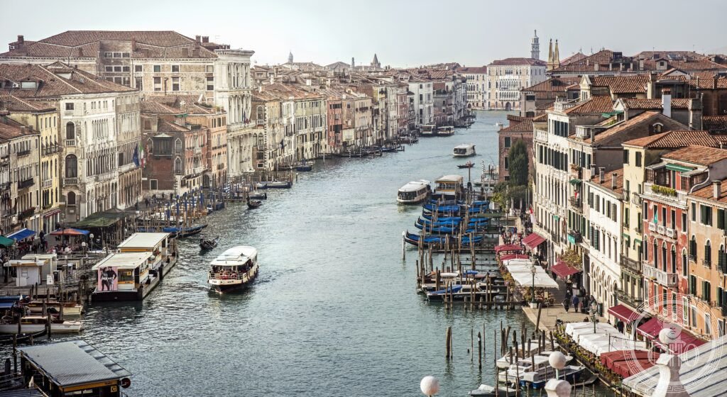
The Grand Canal is Venice’s main street and its longest uninterrupted view: a broad, curving waterway lined by more than 170 Gothic, Renaissance and Baroque palaces, crossed by the Rialto Bridge, and travelled daily by vaporetti, gondolas and the ordinary business of a city built entirely on water.
At a glance
Venice stands on 118 islands within its lagoon, held together by 177 canals and 391 bridges. The Grand Canal is the widest and busiest of these waterways, winding for about 3.8 kilometres in a broad reversed-S curve from Santa Lucia station to the Bacino di San Marco, and functioning as the city’s principal traffic artery: it carries the public vaporetto service, with Line 1 stopping at every landing stage along its length, as well as private water taxis and gondolas.
The city is slowly sinking, by a small margin each year, while sea levels rise with climate change. The MOSE surge barrier system, with flap gates across the lagoon’s inlets, has been operational since November 2020 and is designed to hold back the most severe tides.
Key facts
- Length and width: The Grand Canal runs for about 3.8 kilometres through the centre of Venice in a broad S-curve, varying between roughly 30 and 90 metres wide with a depth of around five metres.
- Palaces: More than 170 Gothic, Renaissance and Baroque palaces line its banks, among them Ca’ d’Oro (1428–1430), whose name recalls the gold gilding once applied to its Gothic tracery, Ca’ Foscari, built in 1453 for Doge Francesco Foscari and now part of the University of Venice, Ca’ Rezzonico, a Baroque palace by Giorgio Massari (17th century, completed by Longhena’s plan) now a museum of eighteenth-century Venetian life, Palazzo Grimani (1556, Michele Sanmicheli), and Ca’ Pesaro (1710, Baldassarre Longhena).
- Rialto Bridge: Built between 1588 and 1591 to a design by Antonio da Ponte, it is a single stone arch lined with shops; earlier wooden versions had crossed the canal here since the 12th century.
- Basilica di Santa Maria della Salute: Standing where the canal opens into the San Marco Basin, it was raised as a votive offering after the plague of 1630.
- Regata storica: a ceremonial boat race on the Grand Canal, held annually each September since the 14th century.
- Heritage status: Venice and its Lagoon has been inscribed as a UNESCO World Heritage Site since 1987.
- Location: 45.4408° N, 12.3155° E.
History
Venice is thought to have been founded by refugees fleeing the Hunnic and later Lombard invasions of mainland Italy between the fifth and seventh centuries, when settling on the lagoon’s islands offered the only viable defence. The Grand Canal itself is thought to follow the course of an ancient river channel — possibly the Rivo Alto — that predates the city’s foundation. As Venice grew from a cluster of lagoon islands into a maritime empire, the canal became its commercial spine, lined with warehouses (fondaci) and the patrician palaces of families who controlled trade routes to the eastern Mediterranean.
The Republic of Venice, the Serenissima, endured from 697 to 1797, governed by a Doge elected through a deliberately complex, multi-stage process designed to prevent any one faction from controlling the outcome. At its height the Republic controlled trade routes to Constantinople and the Levant, a network that produced figures such as Marco Polo, born in Venice around 1254. The Republic’s independence ended in 1797, when Napoleon dissolved it.
What you see
Arriving by train at Santa Lucia station, a visitor steps out to find the Grand Canal immediately in front of them; arriving by water taxi from the airport offers a longer approach along the same route. Along the canal itself, Gothic, Renaissance and Baroque façades follow one another in close succession, punctuated by the single stone arch of the Rialto Bridge with its lining of small shops.
Gondolas, still built with the left side made wider than the right to offset the force of a single oar worked from the stern, share the water with vaporetti and taxis. Licensed gondoliers must pass a demanding examination, and the profession remains largely closed to outsiders. During acqua alta, the seasonal high tides that flood Piazza San Marco and the narrow calli, raised wooden walkways are laid out so pedestrians can keep moving through the flooded streets.
Piazza San Marco itself, once called by Napoleon the finest drawing room in Europe, opens onto the Basilica di San Marco, an eleventh-century Byzantine building whose interior is covered in mosaic and whose Pala d’Oro altarpiece is set with thousands of precious stones.
Cultural significance
The Grand Canal is among the most painted, photographed and written-about urban scenes in history, from Canaletto’s eighteenth-century vedute to Thomas Mann’s Death in Venice. It remains the functional core of a living city that must balance the preservation of its unparalleled heritage with the pressures of mass tourism and acqua alta flooding.
Practical information
- Vaporetto: Line 1 stops at every landing stage along the canal (about 45 minutes end-to-end); Line 2 is the express, with fewer stops (about 25 minutes). Check actv.it for current fares, or arrange a Venezia Unica card before arrival.
- Entry fee: Venice charges day visitors an entry fee on certain peak days; check the city’s official tourism channels for current terms before travelling.
- Acqua alta season: High water is most likely between November and March. The MOSE barrier is intended to hold back the most severe tides, though smaller floods can still affect Piazza San Marco.
Getting there
Venice Santa Lucia station has direct train connections from Milan, Rome and Florence. From Venice Marco Polo airport, a short distance north of the city, travellers can reach Piazzale Roma by water taxi or ACTV bus, or take the Alilaguna water bus, including the Orange line, direct to San Marco. Vaporetto Line 1 then runs the full length of the Grand Canal.
See the place
Nearby
- Murano — reached by vaporetto from Fondamente Nove; centre of Venetian glassblowing since 1291.
- Burano — a short vaporetto ride away; known for its brightly coloured fishermen’s houses and its needle lace tradition, Punto in Aria.
- Torcello — settled before the main Venetian islands, in the seventh century; home to the Basilica of Santa Maria Assunta and its eleventh-century Last Judgement mosaic.
- Verona — about 110 kilometres west by train; a UNESCO World Heritage Site since 2000, with its Roman Arena, the Romeo and Juliet balcony and the medieval Piazza delle Erbe.
- Padua — about 35 kilometres west by train; home to Giotto’s Scrovegni Chapel frescoes of 1303–1305, along with the Palazzo della Ragione and the Basilica of Sant’Antonio.
Sources
- Grand Canal — Wikipedia
- UNESCO — Venice and its Lagoon
- Jan Morris, Venice, Faber & Faber, 1960 (revised 1993)
- MOSE Project
Find it on the map
See this place and what’s around it →
📷 Become a Cultural Heritage Online photographer
Share your photos of places: they stay published under your name as the author. The more they're seen, the more you get noticed — and soon a contest will reward the most appreciated photos.
Log in or sign up free to add a photo