Valle Camonica: Incisioni Rupestri Preistoriche
The rock drawings of the Valle Camonica (UNESCO 1979, Italy’s first World Heritage Site) are the largest concentration of prehistoric petroglyphs in the world — over 300,000 individual figures carved on 2,400 rocks across a 70-km Alpine valley over 12,000 years, from the Mesolithic to the Roman period, by the Camunni people whose “rose” symbol became the emblem of the Lombardia region.
At a glance
Valle Camonica incisioni rupestri (the most precisely Camonica zone Capo di Ponte Brescia Lombardia Italy 46.0260 N 10.3580 E UNESCO WHS 1979 reference 94: the scale (the 300,000+ individual figures on approximately 2,400 rocks distributed across 26 municipalities in the 70-km Valle Camonica (from Pisogne at the southern end to Edolo at the north); the largest concentration of prehistoric rock art in the world (comparison: the Tassili n’Ajjer in Algeria is the second largest); the carving technique (percussion carving: a stone tool struck against the rock surface to remove the dark weathering patina (desert varnish) and expose the lighter fresh stone below; the resulting marks are visible from a distance because the contrast between the pale freshly-exposed stone and the dark patinated surface; this technique is also called “pecking” or “incision”)); the time range (the carving sequence: the earliest recognized figures date from c.8000 BCE (Mesolithic: simple geometric shapes and abstract symbols); the Bronze Age (c.2000–800 BCE: the peak production period; approximately 70% of all known Valcamonica figures date from the Bronze Age; the figure types: warriors, plowing scenes, weapons caches, sun symbols, labyrinth symbols); the Iron Age (c.800–15 BCE: the Camunni culture in its historical period; the specific innovation: scenes involving horses become more common; the Camunian rose appears in large numbers); the Roman period (15 BCE–2nd century CE: after the Roman conquest, the carving tradition continued for 1–2 generations but declined rapidly as the Camunni were integrated into the imperial economy; the latest recognizable Roman-period carvings show gladiators and Roman weapons).
Key facts
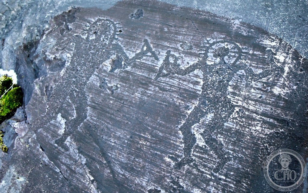
- The Camunian rose (the “Rosa Camuna”) and why it became the symbol of the Lombardia region in 1975: the symbol (the Rosa Camuna: a spoked wheel-like design, typically with 4–8 spokes radiating from a central ring; the symbol appears carved on approximately 900 separate rocks in the Valcamonica; it is unique to this valley — it does not appear with the same frequency or the same form in other rock art traditions; the specific form: the most common version has a central circle and 4–6 curved spokes; the name “Rosa” (rose) is the modern popular name — it was not used by the Camunni; the original Camunni meaning of the symbol is unknown; hypotheses: (a) a solar symbol; (b) an abstract representation of a wheel (the earliest wheel appears in the Bronze Age); (c) a proprietary mark (a “signature” of a Camunni clan or family)); the 1975 adoption (the Regione Lombardia, created in 1970 CE as part of the Italian regionalization reform, chose the Rosa Camuna as its official symbol by regional council vote in 1975 CE — 4 years before the UNESCO inscription; the specific argument for adoption: the symbol (1) is unique to the Lombard territory, (2) predates all historical political entities (it is older than the Lombards, the Romans, and the Celts who all passed through the valley), (3) is not associated with any single religion or ethnic group; the symbol appears on the license plates of Lombard vehicles and on official Regione Lombardia documents)
- GPS (Parco Nazionale di Naquane): 46.0260° N, 10.3580° E
History
From the Mesolithic hunter-gatherers to the Bronze Age Camunni to the Roman conquest to the modern re-discovery (the most precisely Camonica zone history: the discovery (1909 CE: Gualtiero Laeng (a local natural history enthusiast) identified the first Valcamonica rock carvings at Cemmo (a village 2 km from Capo di Ponte); 1914 CE: the first academic publication by the geologist Giovanni Battista Cacciamali; 1956 CE: Emmanuel Anati (an Israeli-Italian archaeologist; born 1930 CE; later the founding director of the Centro Camuno di Studi Preistorici (CCSP) in Capo di Ponte) began the first systematic survey; 1979 CE: the UNESCO inscription (the first ever World Heritage Site inscribed in Italy; reference 94; inscribed at the inaugural meeting of the World Heritage Committee in Cairo-Luxor, January 1979 CE)); the Camunni culture (the Iron Age historical context: the Camunni are first mentioned in Latin sources by Pliny the Elder (Natural History, VII.2.21) as an Alpine people who were conquered by the Romans under the general Publius Silius Nerva in 16 BCE; the Trophée des Alpes (the victory monument at La Turbie above Monaco, 6 BCE) lists the Camunni as one of the 45 Alpine peoples defeated; after Roman conquest, the Camunni received Roman citizenship and the valley was integrated into the Brixia (Brescia) municipal territory; the specific archaeological evidence for the transition: the last Bronze and Iron Age carvings are dated by comparison with similar objects in datable archaeological contexts (burial deposits, hoards); the Roman-period carvings are identified by the appearance of Roman weapons types and Latin letters in the scratched-in graffiti).
What you see
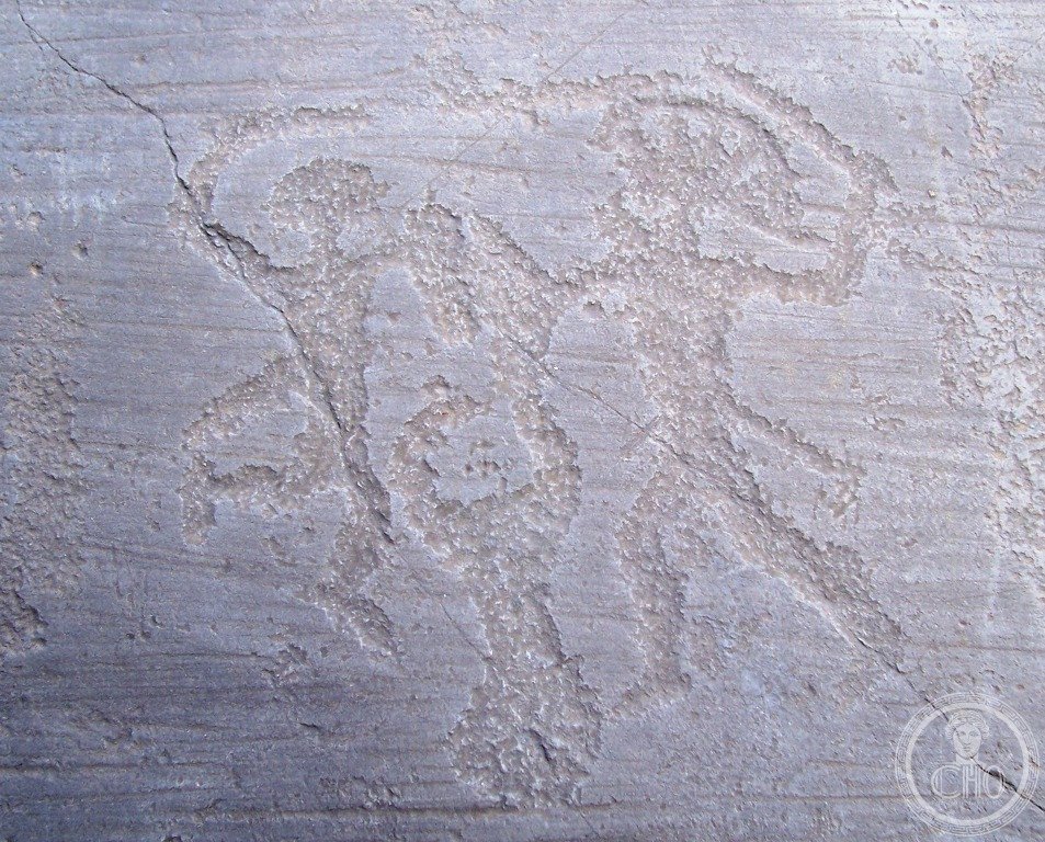
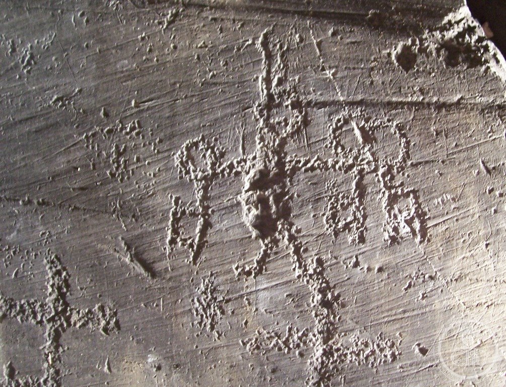
The Parco Nazionale di Naquane, the Parco Archeologico dei Massi di Cemmo, and the walking trail between them (the most precisely Camonica zone visit (2–3 hours): the Parco Nazionale delle Incisioni Rupestri di Naquane (the main UNESCO site; Capo di Ponte; Via Nazionale 79; open Tue–Sun 8:30 AM–7:30 PM (Apr–Sep) / 8:30 AM–4:30 PM (Oct–Mar); €4; the key rock (Rock 1 at Naquane: the largest inscribed rock in the park; 21 m high × 75 m long; 1,000+ figures on the visible face; the viewing path runs along the base of the rock with interpretive panels identifying the major figure groups; the most legible figures are at eye level; the hunting scenes (deer being chased by dogs and hunters with bows) are visible in the lower-left zone; the praying figures (orantes; arms raised) are in the center right; the plowing scene (a man guiding a plow pulled by an ox, with a sower behind) is in the upper right zone — this is one of the earliest representations of plowing in European art (c.1800 BCE))); the Parco Archeologico dei Massi di Cemmo (2 km from Naquane; Cemmo di Capo di Ponte; open same hours; €2; the 2 stele (the Cemmo stele 1 and 2: tall engraved monolithic stones (2.5 m high) with elaborate Bronze Age carvings; likely used as funerary or ritual markers; the figures on the stele include weapons, animals, and the Rosa Camuna; they are among the oldest large-scale figurative stones in Europe (c.2700 BCE))).
Practical information
- Getting to Capo di Ponte and planning the visit for maximum legibility of the rock carvings: transport (Trenitalia from Brescia to Capo di Ponte: 1h30 on the Brescia–Edolo mountain railway (the “linea delle valli camune”); 4–6 trains per day from Brescia; the station is 400 m from the Naquane park entrance; from Milan: change at Brescia (Frecciarossa 30 min from Milan Centrale); best visibility time (the Permian sandstone carvings are most visible when the sun is at a low angle and casts shadows in the scratched grooves; the best times are: morning (8:30–10:00 AM; east-facing rocks are lit from behind the visitor; the shadows highlight the pecking texture); late afternoon (4:00–6:00 PM Mar–Sep); avoid midday (the flat overhead light reduces contrast); avoid direct rain (the wet wet surface darkens uniformly and reduces the scratching contrast); the water trick (to improve legibility of faint carvings, the park rangers carry spray bottles and can wet the rock surface — the dark patinated surface absorbs water more slowly than the pale carved surface, briefly increasing contrast); binoculars (useful for the upper sections of Rock 1 at Naquane))
Getting there
Trenitalia Brescia–Edolo (1h30, 4-6/day). Station 400m from Naquane park. Brescia: Frecciarossa from Milan 30 min. Park open Tue-Sun, €4. Best light: 8:30-10am or late afternoon. GPS: 46.0260, 10.3580.
Nearby
- Brescia — 70 km south (Roman Capitolium (73 CE); the Museo di Santa Giulia (UNESCO Longobards site: the monastery church with the Crocifisso di Desiderio (late 8th c. CE; 212 gems and cameos set into a cross); Trenitalia from Capo di Ponte 1h30)
- Lago d’Iseo e Franciacorta — 50 km south (Monte Isola (the largest lake island in Southern Europe); the Franciacorta DOCG wine zone (the only Italian method-champenoise sparkling wine with DOCG status); the Christo “Floating Piers” site (2016 CE; the orange walkway across the lake has been removed but the physical geography (Peschiera Maraglio to Monte Isola) remains))
Gallery

Sources
- Wikipedia, Rock Drawings in Valcamonica; Camunian rose; Camunni; Emmanuel Anati, accessed June 2026
- UNESCO, Rock Drawings in Valcamonica, WHS reference 94, inscribed 1979 (Italy’s first WHS)
- Anati, Emmanuel. Camonica Valley. New York: Knopf, 1961 (the foundational popular account; written 5 years after Anati’s first surveys)
Find it on the map
See this place and what’s around it →📷 Diventa un fotografo di Cultural Heritage Online
Condividi le tue foto dei luoghi: restano pubblicate con la tua firma come autore. Più vengono viste, più ti fai conoscere — e presto un concorso premierà le foto più apprezzate.
Accedi o registrati gratis per aggiungere una fotoDo you manage this place?
This page is read by travellers and heritage enthusiasts who find it on Google. Keep it accurate — and make it work for you. Free for non-profit heritage institutions.