Valcamonica
La Valcamonica (UNESCO 1979, rif. 94) ospita il più grande archivio di arte rupestre preistorica d’Europa — oltre 300.000 incisioni su roccia di arenaria glaciale distribuite in 70 km di valle alpina tra Capo di Ponte e Darfo, dall’8000 BCE al XV secolo CE: una continuità narrativa di 10.000 anni incisa dal popolo dei Camunni che i Romani non riuscirono a assimilare completamente.
At a glance
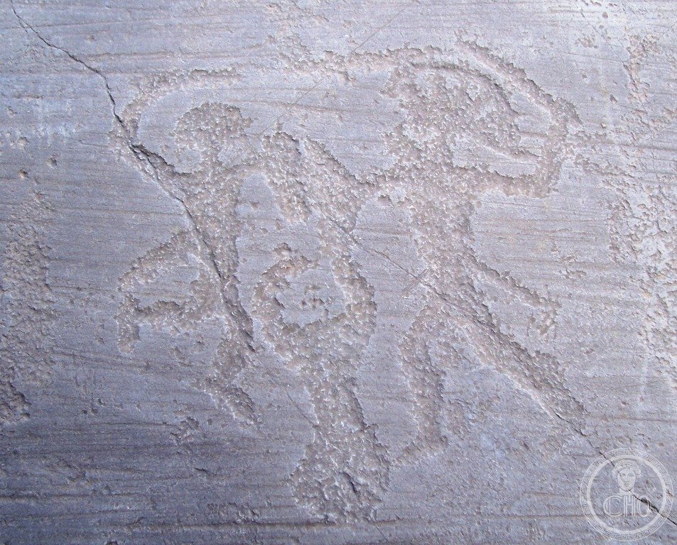
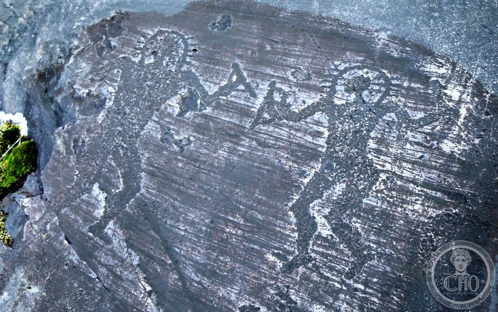
Valcamonica Brescia Lombardia (the most precisely Valcamonica zone Capo di Ponte Brescia Lombardia Italy 46.0344 N 10.4250 E UNESCO WHS 1979 reference 94 Rock Drawings in Valcamonica: the site (the UNESCO inscription: the inscribed property covers the major rock drawing sites in the Valcamonica valley (Val Camonica: a glacially carved valley in the Pre-Alps of Lombardy, 90 km NNE of Brescia, between the Lago d’Iseo (185 m asl) and the Tonale Pass (1,883 m asl)); the numbers (the total inventory: 300,000+ individual petroglyphs (rock engravings) inventoried on approximately 2,400 individual rock surfaces as of 2026; the most recent comprehensive survey (2019 CE, Museo Nazionale della Preistoria della Valle Camonica + CNR): 322,000 petroglyphs confirmed); the rock surface (the rock: Permian sandstone (280 million years old; the “pietra di Naquane”): the smooth glacially polished upper surfaces (the “piane di Naquane”: the horizontal sandstone slabs at 850–1050 m asl above Capo di Ponte that were polished flat by the last Würm glacier (20,000 BCE)); the petroglyphs were created by “pecking” (the technique: a stone tool (flint or quartzite) struck against the sandstone surface, removing the dark oxidized layer and exposing the lighter interior; the resulting light-on-dark image is visible from 2–50 m depending on the sun angle; the best light: low sun (7:00–10:00 or 15:00–18:00) at oblique angle); the chronology (8 main phases from 8000 BCE to the 16th century CE): Phase 1 (8000–5000 BCE: naturalistic animal images; aurochs, red deer, elk; 5% of total); Phase 2 (5000–2000 BCE: Neolithic/Copper Age; human figures, geometric symbols, the “oranti” (praying figures with raised arms); 20% of total); Phase 3 (2000–1000 BCE: Bronze Age; daggers, axes, wheeled vehicles, the sun disc (the “ruota solare”); 40% of total): the largest phase; Phase 4 (1000–200 BCE: Iron Age; warriors, deer hunt scenes, the “Rosa Camuna” appears; 30% of total); Phases 5–8 (200 BCE – 1600 CE: Roman and post-Roman additions; reduced frequency; some Latin inscriptions).
Key facts
- La Rosa Camuna: perché il simbolo della Regione Lombardia è un petroglifo dell’Età del Ferro (900-400 BCE) di cui nessuno conosce ancora con certezza il significato: the Rosa Camuna (the Rosa Camuna (the “Camunian Rose”): the most famous petroglyph of Valcamonica; the symbol of the Regione Lombardia (adopted as the official regional symbol by the Regione Lombardia in 1975 CE): a stylized floral or labyrinthine motif consisting of 4 curved petals arranged around a central square (the schematic pattern: similar to a 4-petaled rose or a yin-yang symbol with 4 arms); the distribution (the Rosa Camuna appears on approximately 90 individual rock surfaces in Valcamonica (Capo di Ponte: 45; Nadro: 20; Cimbergo: 10; Paspardo: 15)); the date (the Rosa Camuna: Iron Age (900–400 BCE) on the basis of stratigraphic position and association with other Iron Age symbols (spiral knives, triangular daggers, warriors with helmets)); the meaning (unknown: the hypotheses: (1) solar symbol (the 4-petaled structure = the 4 seasons / 4 cardinal directions; the curved arms = movement / rotation; supporting evidence: association with solar discs on some rocks); (2) game board (a game similar to “solitaire”: the central square = the playing field; the 4 arms = 4 players; counter-evidence: no game pieces found in Valcamonica excavations); (3) territorial marker (the Rosa Camuna appears only in Valcamonica and nowhere else in Alpine rock art: this geographic exclusivity suggests a clan symbol of the Camunni people); (4) map symbol (a topographic view of a settlement with central square (public space) and 4 roads))
- GPS (Parco Nazionale delle Incisioni Rupestri, Capo di Ponte): 46.0344° N, 10.4250° E
History
Da 8000 BCE al UNESCO 1979 (the most precisely Valcamonica zone history: the discovery (the scientific discovery of Valcamonica rock art: August 26, 1909 CE by Winifred Lamb (the British archaeologist) and Clarence Bicknell (the British botanist and archaeologist, 1842–1918 CE; resident in Bordighera, Liguria): the first professional description of the Valcamonica petroglyphs: a paper presented to the International Prehistoric Congress in Monaco (1906 CE); the earlier mentions (the Padre Don Luigi Moner, a local priest in Darfo, described “strange marks on the rocks” in a 1887 CE letter to the Ateneo di Brescia: the first written record); the systematic study (the systematic study of Valcamonica began with Emanuel Anati (the Israeli-Italian archaeologist, born 1930 CE; Director of the Centro Camuno di Studi Preistorici, founded 1964 CE in Capo di Ponte): Anati’s team inventoried 60,000 petroglyphs from 1954 to 1967 CE (the first systematic inventory); the Anati chronology (the 4-phase Anati chronology (Anati 1960 CE, modified 1994 CE) is the standard framework for Valcamonica rock art dating)); the UNESCO inscription (1979 CE: the FIRST Italian site inscribed in the UNESCO World Heritage List (the first World Heritage list: 12 sites inscribed in 1978 CE (the “inaugural 12”: L’Alhambra, Chartres, Aachen, Galöapagos, Simien, Yellowstone, Krakow, Quito, Ngorongoro, Virunga, Tikal, Mesa Verde)); Italy joined in 1979 CE with the first inscription being Valcamonica (reference 94: inscribed on 1979-09-05)).
What you see
Il Parco di Naquane, le “piane” e la Rosa Camuna (the most precisely Valcamonica zone visit (2–4 hours for the main sites; full day for Naquane + Cemmo + Ceto): the Parco Nazionale delle Incisioni Rupestri di Naquane (the main site; Via Nazionale 79, Capo di Ponte; €5; Tue–Sun 8:30–19:30 (closes 16:00 October–March); the “piane di Naquane” (the main rock surfaces: 104 numbered rock surfaces; the surface n.1 (the “Roccia Grande”): the largest single rock surface with over 1,000 petroglyphs; the self-guided trail: 2.5 km; elevation gain: 120 m; walking time: 1.5 hours for the main surfaces; audio guide (app “Valcamonica Rupestre”: iOS + Android; free; Italian + English)); the light (the best visit time for photography: the morning visit (8:30–11:00) or late afternoon (16:00–18:30) when the oblique sun angle makes the petroglyphs visible; midday sun makes the carvings invisible (flat light)); the Museo Nazionale della Preistoria della Valle Camonica (Palazzo Federici, Capo di Ponte center: 5 min from the park entrance; free; Tue–Sat 8:30–14:00; the cast collection: 1:1 plaster casts of 15 major rock surfaces, some with fiber-optic lighting that can simulate oblique sun angle; the Anati archive: 300,000 drawings + 60,000 archaeological photographs).
Practical information
- Come raggiungere Capo di Ponte da Brescia, e la scarsa segnaletica dei siti minori oltre al Parco di Naquane: il trasporto (Brescia → Capo di Ponte: Trenord (linea RE10; partenza da Brescia Stazione; 1h15; ogni 30 min in settimana, ogni 60 min nel weekend; €5.40); la stazione di Capo di Ponte (la stazione ferroviaria è a 300 m dal Parco di Naquane: uscire dalla stazione, girare a destra sulla Via Nazionale per 300 m); i siti minori (oltre al Parco di Naquane, la Valcamonica ha 70+ siti di incisioni rupestri accessibili; i più importanti con cartellonistica adeguata: (1) Riserva Naturale Incisioni Rupestri di Ceto, Cimbergo e Paspardo (10 km da Capo di Ponte: la Via delle Scope ha la maggior concentrazione di Rosa Camuna); (2) Parco Archaeologico Comunale di Seradina-Bedolina (Capo di Ponte, 2 km dal Parco Naquane: la Roccia Bedolina (“topographic map”: il petroglifo che mostra una presunta mappa topografica di un villaggio dell’Età del Ferro)); la segnaletica (i siti minori hanno segnaletica insufficiente; scaricare la mappa dal sito ufficiale (parcoincisioni.it/mappa) prima di partire))
Getting there
Trenord da Brescia (1h15, €5.40, RE10). GPS Parco Naquane: 46.0344/10.4250. €5. Mart-Dom 8:30-19:30 (chiude 16:00 ott-mar). Luce migliore: mattina 8:30-11:00 o sera 16:00-18:30.
Nearby
- Lago d’Iseo e Monte Isola (il lago con la più grande isola lacustre abitata d’Europa) — 30 km (Trenord da Capo di Ponte → Pisogne → traghetto verso Monte Isola; Monte Isola: 4.5 km²; 1.750 abitanti; nessuna auto; solo biciclette e motoscafi; la Pieve di Sant’Andrea (sec. XI CE); la rete produzione reti da pesca: 600 tonnellate/anno; la Christo “Floating Piers” 2016 CE: ancora la struttura più vista su Instagram tra le opere effimere di Christo)
- Brescia (centro storico romano + Pinacoteca Tosio-Martinengo) — 45 km (Trenord 1h15; il Capitolium romano (73 CE; 3 celle del tempio; i bronzi dorati rinvenuti 1826 CE; Parco Archeologico di Brescia Romana; €8); Moretto da Brescia e Romanino alla Pinacoteca Tosio-Martinengo)
Gallery


Sources
- Wikipedia, Rock Drawings in Valcamonica; Rosa Camuna; Camunni; Emanuel Anati, accessed June 2026
- UNESCO, Rock Drawings in Valcamonica, WHS reference 94, inscribed 1979 (first Italian inscription)
- Anati, Emanuel. Camonica Valley. London: Jonathan Cape, 1964 (the foundational survey)
Find it on the map
See this place and what’s around it →📷 Diventa un fotografo di Cultural Heritage Online
Condividi le tue foto dei luoghi: restano pubblicate con la tua firma come autore. Più vengono viste, più ti fai conoscere — e presto un concorso premierà le foto più apprezzate.
Accedi o registrati gratis per aggiungere una foto