Trowulan
The dispersed archaeological zone of Trowulan in East Java preserves the remains of the capital of the Majapahit Empire — the largest and most powerful Hindu-Buddhist empire in the history of Southeast Asia, which at its greatest extent controlled or claimed suzerainty over virtually all of present-day Indonesia, Malaysia, and parts of mainland Southeast Asia.
At a glance
Trowulan extends over approximately 100 km² of flat East Java lowlands near the town of Mojokerto, 60 km southwest of Surabaya. A 15th-century Chinese source describes the city as containing 100,000 families; modern estimates suggest a population of 200,000-500,000 at the capital's peak, served by an extensive hydraulic infrastructure of canals, ponds, and dams still visible in aerial and satellite imagery. The Majapahit Empire at its height (c. 1365 AD) controlled trade routes, culture, and political allegiance across the Indonesian archipelago from Sumatra to New Guinea. The name Nusantara — now adopted for Indonesia's new capital city — is a Majapahit term meaning "outer islands." The surviving monuments include extraordinary brick gateways, water temples, and temple complexes scattered across the archaeological zone.
Key facts
- Location: Near Mojokerto, East Java Province, Indonesia — approximately 60 km southwest of Surabaya
- Period: c. 1293-1527 AD (Majapahit Empire capital)
- Culture: Hindu-Buddhist Javanese; successor to the Singhasari and Kediri kingdoms
- Extent: Archaeological zone approximately 100 km²; hydraulic infrastructure visible in satellite imagery
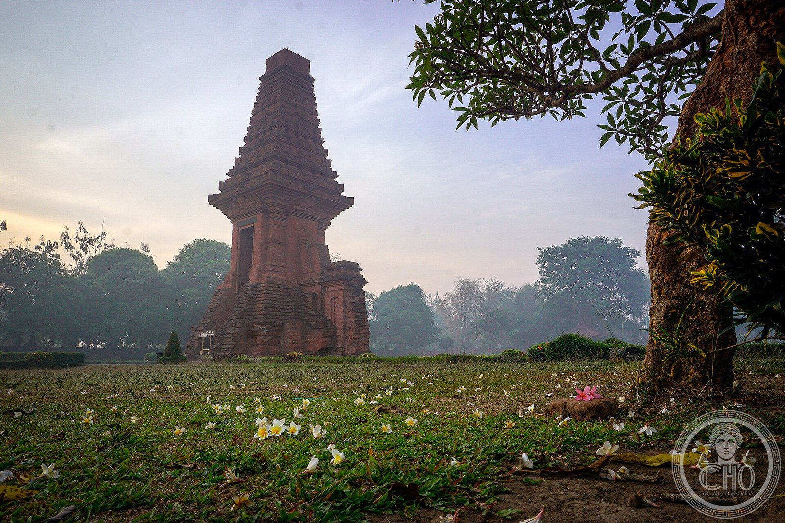
- Key monument: Candi Wringin Lawang — a unique "split gateway" corbelled-vault structure; Bajang Ratu gateway; Tikus water temple
- Historical source: Nagarakretagama (1365 AD), an Old Javanese poem listing 98 Majapahit tributaries
- Managed by: Indonesian cultural heritage authorities (Balai Pelestarian Cagar Budaya); Trowulan site museum on site
History
The Majapahit Empire was founded in 1293 AD when Raden Wijaya defeated a Mongol fleet that had been invited to Java by a rival kingdom and then turned against it — a piece of political improvisation that established his legitimacy as the founder of a new dynasty. The capital Trowulan, in the fertile plain of East Java watered by the Brantas River, became the centre of an empire that grew over the following 70 years to become the most extensive Hindu-Buddhist polity in Southeast Asian history. Its greatest moment came under King Hayam Wuruk (r. 1350-1389 AD) and his brilliant prime minister Gajah Mada, who swore a famous oath not to eat spiced food ("palapa") until he had unified the entire Indonesian archipelago under Majapahit authority — an oath that historians debate in terms of its literal accuracy but which captures the empire's genuine territorial ambition.
The Nagarakretagama, a court poem composed by the Buddhist monk Prapanca for the royal court in 1365 AD, provides an extraordinary window into Trowulan's urban life: it describes the capital's layout, its religious buildings, the royal court's rituals, and lists the 98 territories acknowledging Majapahit suzerainty from Borneo to the Moluccas and New Guinea. Archaeological evidence confirms the poem's picture of a sophisticated urban centre: the hydraulic infrastructure of reservoirs and canals (some up to 1 km long) supplied the capital's population and regulated seasonal flooding; the scatter of brick monuments across the 100 km² zone represents the remains of palaces, temples, aristocratic compounds, and industrial facilities including metalworking and pottery production at industrial scale.
The Majapahit's decline in the late 15th and early 16th centuries appears to have been caused by a combination of civil wars, the rise of Islamic trading states on the Java coast (particularly Demak), and the disruption of trade networks by the Portuguese arrival in Southeast Asian waters after 1511. By approximately 1527 AD the capital was abandoned. The empire's cultural legacy is enormous: the Javanese, Balinese, and Malay literary, artistic, and political traditions all trace their origins substantially to the Majapahit period; Balinese Hinduism — the direct descendant of Majapahit court religion — preserves the only surviving tradition of this cosmological world.
What you see today
Trowulan's monuments are dispersed across a wide agricultural zone, requiring a vehicle to visit efficiently. The most striking are the gateways and water structures. The Candi Wringin Lawang is uniquely bizarre: a large corbelled-vault gateway of dark red brick divided vertically into two halves separated by a gap, as if a complete gate had been sliced through the middle with a vast blade. Scholars debate whether it was intentionally built this way as a ritual entrance, or left unfinished; either reading is architecturally extraordinary. The Bajang Ratu gateway, better preserved, is a tapering stepped tower in the characteristic East Javanese style. The Candi Tikus ("Rat Temple") is a sunken water complex used for royal purification rituals — it was rediscovered in the 20th century when a farmer's field flooded and the water turned out to be draining into an ancient bath complex below ground.
The Trowulan site museum provides essential context: it holds a large collection of Majapahit terracotta figurines, architectural fragments, coins, ceramics, and decorative elements recovered from the site, as well as scale models of the capital's hydraulic infrastructure. The museum gives what the open-air ruins cannot: a concentrated visual sense of the material culture of the Majapahit world. Outside the museum, the scale of the archaeological zone is itself an experience — driving through rice paddies that conceal reservoir earthworks and brick foundations communicates the density of a city that may once have been larger than contemporary London or Paris.
Practical information
- Entry: Small entrance fee at each monument; the Trowulan museum has a separate ticket
- Opening hours: Generally 8:00-17:00 daily; confirm locally as hours can vary
- Getting around the zone: Hire a motorcycle taxi (ojek) or car with driver in Mojokerto or Trowulan village; monuments are spread over 10+ km
- Time needed: A full day to see the main monuments and the museum; half-day for museum + two or three key sites
- Best time to visit: May-October (dry season in East Java); avoid wet season if possible as some sites flood
- Accommodation: Hotels in Mojokerto; day trip from Surabaya (60 km) is common
Getting there
Trowulan is approximately 60 km southwest of Surabaya via the toll road toward Mojokerto. From Surabaya Juanda International Airport, a car or taxi takes approximately 1 hour. From Surabaya city centre, local buses run to Mojokerto (journey 1.5-2 hours); from Mojokerto, local transport (ojek, becak) covers the final kilometres to the archaeological zone. Train services connect Surabaya to Mojokerto in approximately 45 minutes from Surabaya Gubeng or Pasar Turi stations. Yogyakarta is approximately 300 km west (4-5 hours by car or 4 hours by express train via Surabaya).
Nearby heritage
- Candi Penataran (near Blitar, 80 km southwest) — the largest temple complex of the Majapahit period, still in its original landscape; dedicated to Shiva, built over 250 years from the 12th to 14th centuries
- Bromo-Tengger-Semeru National Park (100 km east) — the volcanic landscape considered sacred under Majapahit cosmology; still inhabited by the Hindu Tengger people, direct cultural descendants of the Majapahit tradition
- Mojokerto Museum (Mojokerto city) — additional Majapahit artefacts and inscriptions, complementing the Trowulan site museum
Sources
- Prapanca (1365 AD / trans. Robson 1995). Nagarakretagama. KITLV Press, Leiden.
- Miksic, J.N. (2013). Singapore and the Silk Road of the Sea, 1300-1800. NUS Press (with extensive Majapahit context).
- Christie, J.W. (1995). State formation in Early Maritime Southeast Asia. Bijdragen tot de Taal-, Land- en Volkenkunde, 151(2).
- Hadi Sidomulyo (2008). Trowulan — Ibu Kota Majapahit. Wedatama Widya Sastra, Jakarta.
- Wikipedia — “Trowulan” (accessed June 2026).
Find it on the map
See this place and what’s around it →📷 Diventa un fotografo di Cultural Heritage Online
Condividi le tue foto dei luoghi: restano pubblicate con la tua firma come autore. Più vengono viste, più ti fai conoscere — e presto un concorso premierà le foto più apprezzate.
Accedi o registrati gratis per aggiungere una foto