Toniná
The most militaristic Maya city, home to the world’s tallest pre-Columbian structure — and the last Long Count date ever carved in stone.
At a glance
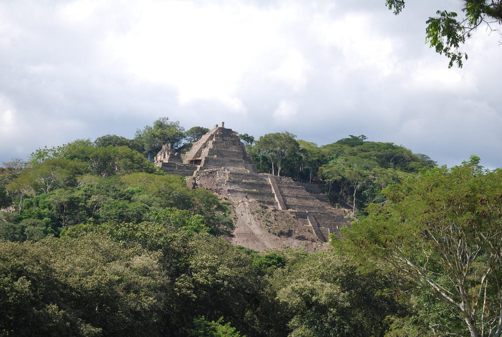
Fourteen kilometres east of Ocosingo in the Chiapas highlands, Toniná is an imposing Maya city whose defining feature is a single artificial hill reshaped over centuries into a seven-tiered palace-pyramid complex. At approximately 71 metres in total height, it is the tallest pre-Columbian structure in the world — taller than the Pyramid of the Sun at Teotihuacan or the Great Pyramid of Cholula — yet it reads from a distance as a natural hill with temples on top, which is why this record remains little known outside specialist circles. The city was also the most militaristic of all Classic Maya polities and outlasted the wider Maya collapse: the latest Long Count date ever found in the Maya world was carved here, in 909 AD.
Key facts
- Location: Ocosingo valley, Chiapas highlands, Mexico (14 km east of Ocosingo)
- GPS: 16.9013° N, 92.0069° W
- Period: c. 300–909 AD (Classic Maya)
- Maximum height: ~71 m (tallest pre-Columbian structure in the world)
- Notable event: Capture of Palenque’s king K’an Joy Chitam II, 711 AD
- Latest Long Count date: Monument 122, equivalent to 15 January 909 AD
- Access: Open site; small museum on-site; 45 min drive from San Cristóbal de las Casas
History
Toniná was occupied from at least 300 AD and reached its political peak during the Late Classic period (600–900 AD). Its rulers pursued an almost exclusively military foreign policy, waging constant war against neighbours across the Usumacinta region and beyond. Captive-taking was the central theme of the city’s art programme: stelae and altars across the site record defeated warriors from Yaxchilán, Bonampak, and Palenque. The most celebrated trophy was K’an Joy Chitam II, king of the great city of Palenque, captured in 711 AD — an event that effectively ended Palenque’s political independence. The victory was commemorated on multiple monuments.
While most Classic Maya cities collapsed between 800 and 850 AD, Toniná endured. Monument 122, discovered in 1992, bears a Long Count date equivalent to 15 January 909 AD — the latest such inscription ever found in the Maya world, approximately two decades after the last dated monument at any other major Maya site. After this date, the historical record goes silent. The site was gradually reclaimed by the forest and was not systematically excavated until the late twentieth century; current excavations by Mexico’s INAH (National Institute of Anthropology and History) are ongoing.
What you see
The pyramid-palace is not a single stepped pyramid in the Tikal or Chichen Itza sense, but a natural hill that the Maya builders terraced and built upon over generations, producing seven distinct levels connected by steep staircases. Each level contains different structures: temples, long palatial room-suites, storage areas, and — on Level 3 — a ball court. The complex contains numerous dark, corbel-vaulted underground chambers that served as dungeons, where captured warriors were held before sacrifice. On Level 6, the stucco frieze known as “The Four Eras” depicts the four cosmological ages of Maya creation mythology in large-scale relief — one of the finest surviving examples of Classic Maya monumental stucco sculpture.
The site museum (Museo Regional de Toniná) displays a large collection of carved monuments including stelae, altars, and disembodied stone heads of captives. The prize piece is a large circular altar showing bound captives arranged around a central disk, and several panels recording the dynastic history of the city’s rulers. The jungle setting in the mountain valley is dramatic: the pyramid rises above a wide grass forecourt with cloud-forested ridges on three sides.
Practical information
- Hours: Daily 9:00–17:00 (last entry 16:30)
- Admission: Approx. MXN 85 (INAH federal site); includes museum
- On-site: Small museum, ticket office, basic refreshments; no accommodation
- Photography: Freely permitted throughout
- Fitness note: Climbing to the pyramid top requires steep stairs and reasonable fitness; allow 2–3 hours for the full site
Getting there
From San Cristóbal de las Casas: approximately 90 km (1.5 hours) east via highway MEX-190 to Ocosingo, then 14 km south on a local road. Colectivos and minibuses run frequently from Ocosingo’s market to the site entrance. From Palenque: approximately 170 km (3 hours) south via highway MEX-199 through the Ocosingo valley — a scenic mountain route. No direct bus from San Cristóbal; change in Ocosingo.
Nearby
- Palenque — 170 km north, the great Classic Maya city captured by Toniná in 711 AD; temples and extraordinary Palace complex
- Agua Azul waterfalls — 85 km northwest, turquoise cascades in the Chiapas jungle; common day-trip pairing with Palenque
- Ocosingo market — 14 km northwest, a working highland Maya market town, good base for the site
- Lagunas de Montebello — 130 km south, a national park with 59 multi-coloured lakes in pine-oak forest
Sources
- Martin, S. & Grube, N. (2008). Chronicle of the Maya Kings and Queens. Thames & Hudson.
- Becquelin, P. & Baudez, C. (1979–1982). Toniná, une cité maya du Chiapas. Mission Archéologique et Ethnologique Française au Mexique.
- INAH — Instituto Nacional de Antropología e Historia, official site documentation.
- Stuart, D. (2004). “The Beginnings of the Copan Dynasty.” Understanding Early Classic Copan. UPenn Museum.
- Wikipedia: Toniná
Find it on the map
See this place and what’s around it →📷 Diventa un fotografo di Cultural Heritage Online
Condividi le tue foto dei luoghi: restano pubblicate con la tua firma come autore. Più vengono viste, più ti fai conoscere — e presto un concorso premierà le foto più apprezzate.
Accedi o registrati gratis per aggiungere una foto