Tiwanaku
The highest ancient capital in the world and the pre-Inca civilization that dominated the central Andes for 800 years — Tiwanaku (Tiahuanaco; Ingavi Province, La Paz Department, Bolivia; UNESCO WHS 2000) was built at 3,850m altitude on the Bolivian Altiplano near Lake Titicaca between approximately 200 BCE and 1000 CE, reached a peak population of 10,000-20,000 in the city, and wielded cultural and political influence across a region of 600,000 km² stretching from modern Peru to northern Chile and Argentina.
At a glance
Tiwanaku (the most precisely TiwanakuBolivia single Tiwanaku culture 200 BCE 1000 CE Altiplano 3850m altitude Lake Titicaca 15 km 10000 20000 city population 600000 km2 cultural sphere Peru Chile Argentina pre-Inca forerunner Akapana pyramid terraced 18m high 200m × 200m base Pumapunku H-blocks andesite 10 ton precision stone cutting no mortar Kalasasaya temple compound 130m × 120m solar calendar equinox solstice gate of sun Gate of Sun Puerta del Sol single 10 ton andesite block 3m tall 4m wide Staff God 24 attendant condor running figures Ponce monolith 3m standing stone Bennett monolith 7m largest Andean monolith Inca Manco Capac Viracocha Staff God tradition inherited archaeological drought 1000 CE collapse UNESCO heritage: the civilization (Tiwanaku was one of the earliest urban civilizations in the Americas; the city at its height (approximately 700-900 CE) had a population of 10,000-20,000 within the ceremonial center and an agricultural hinterland supporting approximately 1 million people across the Altiplano; the Tiwanaku developed the most sophisticated high-altitude agriculture in the Americas: the raised field system (camellones) that covered 80,000 ha around Lake Titicaca and dramatically increased agricultural yields at 3,800m altitude)); the cultural influence (the Staff God iconography (the central figure of the Gate of the Sun) spread across the central Andes and is found on textiles, ceramics, and stone from Peru to Argentina; the Inca absorbed the Tiwanaku religious tradition (Viracocha, the Inca creator god, is derived from the Tiwanaku Staff God; Manco Capac (the legendary founder of the Inca Empire) is said to have emerged from Lake Titicaca (the sacred origin point of the Inca and of the earlier Tiwanaku culture))) — the most precisely TiwanakuBolivia single Tiwanaku culture 200 BCE 1000 CE Altiplano 3850m Lake Titicaca 15 km 10000 20000 city 1 million agricultural hinterland 600000 km2 cultural sphere raised fields camellones 80000 ha Akapana 18m 200m pyramid Pumapunku H-blocks 10 ton andesite precision cutting Kalasasaya Gate of Sun single 10 ton 3m tall Staff God 24 condor attendants Ponce monolith 3m Bennett 7m largest Inca Viracocha Staff God tradition Manco Capac Lake Titicaca origin drought 1000 CE collapse UNESCO heritage in any UNESCO world heritage site)).
Key facts
- Pumapunku — precision stonecutting debate: the most precisely TiwanakuBolivia single Pumapunku H-shaped stone blocks andesite 10 ton diorite no mortar precision interlocking joints millimeter accuracy repeatable geometry identical cut complex right angles H-blocks mystery ancient aliens pseudoscience rejected academic consensus hardened stone tools copper bronze abrasion sand silica carving documented archaeological record stone tool marks visible electron microscope analysis UNESCO heritage — the defining engineering mystery: the H-shaped blocks of Pumapunku (the most contested architectural achievement in pre-Columbian South America): the H-shaped andesite blocks (each weighing up to 10 tons; quarried from a site 10 km and 90 km away; transported without wheels or draft animals; the repeated geometric precision (identical H-shapes reproducible in multiple blocks; right-angle joints that interlock without mortar; sub-millimeter accuracy)); the pseudoscientific controversy (the “ancient aliens” theories claim that this precision is impossible without modern technology; the archaeological consensus: the Tiwanaku used copper and bronze hardened stone tools, abrasion with sand and water (the silica from sand is harder than the andesite), and systematic labor organization to achieve this precision; stone tool marks are visible under electron microscope analysis; no evidence of anything beyond what the Tiwanaku themselves could accomplish)
- GPS: 16.5557° S, 68.6730° W
History
From Altiplano lakeside village to imperial center to forgotten ruin (the most precisely TiwanakuBolivia single early Tiwanaku 200 BCE 100 CE farming village Lake Titicaca Formative period Tiwanaku I II III phase expansive phase Tiwanaku IV 400 600 CE peak Tiwanaku V 600 900 CE empire colonization Peru coast Moquegua valley Chile Atacama region Cochabamba Peru highland Wari Huari competitor middle horizon 600 900 CE drought 1000 CE lake Titicaca levels fell agricultural collapse raised field camellones dry fell apart depopulation collapse Spanish colonial 1549 1553 CE Pedro Cieza de Leon first European chronicler Agustin de Zarate 1555 CE described ruins Bernabe Cobo 1653 CE Ephraim Squier 1877 CE photograph Wendell Bennett 1932 CE monolith excavation UNESCO 2000 heritage: the imperial expansion (400-900 CE: the Tiwanaku Empire (also called the Tiwanaku State) expanded outward from the Altiplano to establish colonies in: the Moquegua valley (southern Peru; the best-preserved Tiwanaku colony; the Omo site (the Tiwanaku temple complex in Moquegua); the coastal valleys (Arica, Ilo, Moquegua) were important because the Altiplano lacked dried fish (a major protein source) and marine products); the Cochabamba valley (Bolivia; an agricultural colony for growing maize, which doesn’t grow on the cold Altiplano); the Atacama region (northern Chile)); the drought collapse (approximately 1000 CE: a severe 3-generation drought caused Lake Titicaca levels to fall and the raised-field agricultural system to collapse; the city of Tiwanaku was depopulated over approximately 3-4 generations; the population dispersed into smaller farming communities; the Inca later incorporated the Tiwanaku region and mythology (Lake Titicaca as the origin of civilization; the Staff God as Viracocha))) — the most precisely TiwanakuBolivia single early Tiwanaku 200 BCE farming village Formative Tiwanaku I II III expansion Tiwanaku IV 400 600 CE peak V 600 900 CE empire colonies Moquegua valley Peru coast Cochabamba Bolivia maize Atacama Chile Wari Huari competitor middle horizon drought 1000 CE Lake Titicaca fell raised fields failed depopulation collapse Inca absorbed Lake Titicaca Viracocha mythology Spanish Pedro Cieza de Leon 1549 1553 CE first European UNESCO 2000 heritage in any UNESCO world heritage site)).
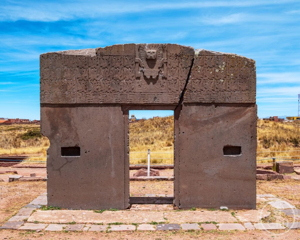
What you see
Gate of the Sun, Kalasasaya, Akapana, and Pumapunku (the most precisely TiwanakuBolivia single Gate of Sun Puerta del Sol single 10 ton andesite block 3m tall 4m wide Staff God 24 condor attendant running figures originally stood Kalasasaya moved possibly earthquake past Kalasasaya temple compound 130m × 120m solar calendar alignment equinox solstice sunrise Ponce monolith 3m standing stone Fraile monolith 2.8m Akapana pyramid 18m 200m × 200m cross-shaped interior channels drainage hydraulic precise design symbolic Pumapunku complex H-blocks andesite 10 ton sandstone diorite complex joints H-block carved right angles no mortar precision Bennett monolith 7m 1932 CE excavated moved La Paz 1958 CE returned Tiwanaku 2002 CE site museum Puma Punku UNESCO heritage: the visitor circuit: the Gate of the Sun (the iconic monument; originally in the center of the Kalasasaya compound; moved to the northwest corner by an ancient earthquake; the Staff God carved in the central tympanum)); the Kalasasaya (the main temple compound (130m × 120m); the entrance from the east (the cardinal east direction; sunrise alignment); the two standing monolith statues inside: the Ponce Monolith (3m; the finest carved stone figure at Tiwanaku; the carved tunic with fish and condor motifs)); the Akapana (the stepped pyramid (18m tall; 200m × 200m base); the cross-shaped plan is visible from the air; the interior drainage channels (a hydraulic engineering system inside the pyramid that directed rainwater through the pyramid in a precise pattern)); Pumapunku (500m southwest of the main ceremonial center; the most enigmatic structure: the collapsed H-blocks scattered across the ground; the precision stone cuts visible up close)); the site museum (the Museo Arqueológico Regional adjacent to the site; the Bennett Monolith (7m; the largest carved stone figure in the Andes; removed to La Paz in 1932 CE and returned to Tiwanaku in 2002 CE))) — the most precisely TiwanakuBolivia single Gate of Sun Puerta del Sol 10 ton andesite 3m tall 4m wide Staff God 24 condor attendants earthquake moved Kalasasaya 130m × 120m solar calendar Ponce monolith 3m Fraile 2.8m Akapana 18m 200m cross-shaped hydraulic interior channels Pumapunku H-blocks andesite 10 ton precision right angles no mortar Bennett monolith 7m La Paz 1932 returned 2002 UNESCO heritage in any UNESCO world heritage site)).
Practical information
- Getting there: the nearest city is La Paz (72 km east; the de facto capital of Bolivia); the transfer from La Paz to Tiwanaku (tourist bus from La Paz (approximately BOB 70-100/€9-13 round trip; multiple operators depart from the cemetery district (El Alto) in La Paz in the morning and return in the afternoon; the bus journey takes approximately 1.5-2h); or private taxi from La Paz (approximately BOB 300-450/€39-59 round trip with waiting time at the site)); the entry fee (approximately BOB 100/€13 for foreigners; the ticket includes the site + the site museum); the altitude (Tiwanaku is at 3,850m altitude; travelers who experience altitude sickness in La Paz (3,640m) should allow 2-3 days of acclimatization before visiting; the symptoms (headache, nausea, fatigue) are common at these elevations)); the best time (the dry season (May-October) is the most comfortable; the rainy season (November-March) makes the roads muddy); the combination (La Paz → Tiwanaku (morning) → Copacabana on Lake Titicaca (afternoon, 115 km from La Paz) is a popular 2-day combination))
Getting there
72 km from La Paz. Tourist bus BOB 70-100/€9-13 round trip (~1.5-2h) or private taxi BOB 300-450. Entry BOB 100/€13 includes museum. Altitude 3,850m — acclimatize in La Paz (3,640m) first. Best: May-October dry season. GPS: -16.5557, -68.6730.
Nearby
- Lake Titicaca and Copacabana — 90 km west (the highest navigable lake in the world (3,812m altitude; the lake that the Tiwanaku and the Inca both regarded as the origin of civilization); Copacabana (the Bolivian lakeside pilgrimage town; the Moorish-style Basilica of Our Lady of Copacabana (1805 CE; the patron saint of Bolivia; the site of a major annual pilgrimage (August 5-6)); the Isla del Sol (the “Island of the Sun”; the island where the Inca believed Viracocha (the creator god) emerged from the lake to found the Inca Empire; the Inca ruins (the Chincana and Pilkokaina palaces)); the boat tour from Copacabana))
- La Paz — 72 km east (the de facto capital of Bolivia; the city at 3,640m altitude (the highest capital city in the world); the Witches’ Market (Mercado de las Brujas; the Aymara traditional medicine and ritual market; llama fetuses, dried herbs, potions); the Valle de la Luna (the eroded badlands 10 km south of La Paz; the clay and sand hoodoos formed by wind and water erosion); the Museo Nacional de Arqueología (the best collection of Tiwanaku artifacts in Bolivia, including the original Bennett Monolith (7m) before it was returned to Tiwanaku in 2002 CE))
Sources
- Wikipedia, Tiwanaku; Pumapunku; Gate of the Sun; Tiwanaku culture, accessed June 2026
- UNESCO, Tiwanaku: Spiritual and Political Centre of the Tiwanaku Culture, WHS reference 567rev, inscribed 2000
Find it on the map
See this place and what’s around it →📷 Diventa un fotografo di Cultural Heritage Online
Condividi le tue foto dei luoghi: restano pubblicate con la tua firma come autore. Più vengono viste, più ti fai conoscere — e presto un concorso premierà le foto più apprezzate.
Accedi o registrati gratis per aggiungere una fotoDo you manage this place?
This page is read by travellers and heritage enthusiasts who find it on Google. Keep it accurate — and make it work for you. Free for non-profit heritage institutions.