Timbuktu — Djinguereber Mosque
The most important monument of medieval West African Islamic civilization — the Friday mosque of the city once called “the City of Gold” and “the Mecca of the Sudan,” built in 1327 by the Spanish-Andalusian architect Abu Es Haq Ibrahim es Saheli at the commission of Mansa Musa, Sultan of Mali, who funded it with the gold dust he brought back from the most extravagant Hajj pilgrimage in Islamic history; a building made entirely of mudbrick and organic materials by a community that has maintained it with their hands every year since its construction.
At a glance
Timbuktu (French: Tombouctou; Koyra Chiini: Tumbutu) is a city in the Tombouctou Region of Mali, in the southern Sahara at the southern edge of the desert and the northern curve of the Niger River, approximately 1,000 km north-east of Bamako. The city reached its peak as a centre of Islamic scholarship, commerce, and culture in the 15th–16th centuries (under the Mali Empire and then the Songhai Empire), when it housed approximately 25,000 scholars and a university at the Sankore mosque complex, and traded gold and salt on a scale that made it the wealthiest city in sub-Saharan Africa. UNESCO inscribed the three great mosques of Timbuktu (Djinguereber, Sankore, and Sidi Yahia) in 1988; the inscription was placed on the List of World Heritage in Danger in 1990 and again in 2012 (after the occupation of northern Mali by jihadist groups and the deliberate destruction of the city’s ancient mausoleums).
Key facts
- Mansa Musa and the Hajj of 1324: Mansa Musa I (c. 1280–1337), Sultan of the Mali Empire, undertook a pilgrimage to Mecca in 1324 that is the most documented and discussed Hajj in Islamic history; his caravan (estimated at 60,000–80,000 people, 12,000 enslaved people, and 100 camels each carrying 135 kg of gold dust) was so large and his distribution of gold so extravagant that he caused inflation in Egypt, Saudi Arabia, and the eastern Mediterranean for 12 years after his passage (the gold price collapsed 25% in Egypt and did not recover for over a decade); modern historians have estimated Mansa Musa’s wealth at $400 billion at current prices, making him the wealthiest individual in recorded history; on his return from Mecca, Mansa Musa brought the architect es-Saheli (a poet and architect from Granada) to Timbuktu to build the Djinguereber Mosque
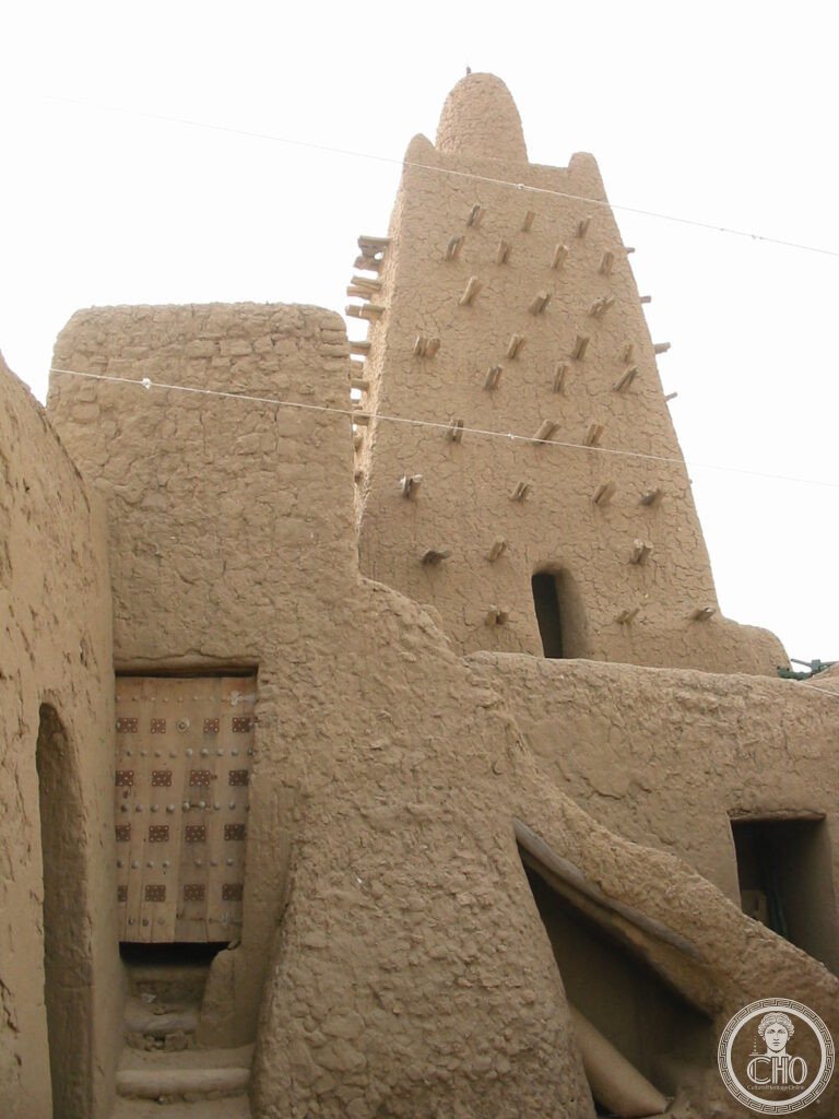
- The mosque (1327): built by Abu Es Haq Ibrahim es Saheli (called “Abu Ishaq al-Sahili” in Arabic sources), a Granadan-born poet and architect who accompanied Mansa Musa from Mecca; the mosque is built in the Sudano-Sahelian style (a West African mudbrick architectural tradition that es-Saheli is credited with formalising or introducing to the region); the floor plan has 25 rows of columns forming a large prayer hall; three pyramid-shaped towers serve as minarets (a unique West African form distinct from the cylindrical or square minarets of North Africa and the Middle East); the mosque can hold 2,000 worshippers; it is still in active use for Friday prayers
- Sudano-Sahelian architecture: the Djinguereber Mosque is the archetype of Sudano-Sahelian (also called Sahelian or Sudanese) architecture — a tradition of building in sun-dried mudbrick with organic timber reinforcements (the wooden beams, called toron, protrude from the walls and serve as permanent scaffolding for the annual re-plastering); the toron-studded walls of the mosque are the visual signature of this architectural tradition; the style is found across the West African Sahel from Djenné (Mali) to Agadez (Niger) to Zinder (Niger) and has been recognised as a distinct and historically important architectural tradition
- The manuscripts of Timbuktu: Timbuktu’s role as an Islamic scholarly centre is documented in approximately 400,000–700,000 manuscripts preserved in private Timbuktu family libraries, covering mathematics, astronomy, medicine, Islamic law, poetry, and history; the manuscripts were written in Arabic (and occasionally in Fulani or Tamasheq with Arabic script) between the 13th and 17th centuries; most were hidden when jihadist groups occupied the city in 2012; approximately 4,000 manuscripts were destroyed by the jihadists before they were driven out; UNESCO and the Mali government have been working since 2013 to digitise and preserve the surviving manuscripts
- 2012 occupation and mausoleum destruction: in 2012, the jihadist group Ansar Dine (affiliated with al-Qaeda in the Islamic Maghreb) occupied Timbuktu and declared the veneration of saints’ shrines idolatrous; in the following months, they systematically destroyed 14 of the 16 sacred mausoleums and shrines in Timbuktu (including those of Sidi Yahia, Alpha Moya, and Sheik el Kettani); the destruction was later prosecuted as a war crime at the International Criminal Court (the conviction of Ahmad al-Faqi al-Mahdi in 2016 was the first ICC conviction for the intentional destruction of cultural heritage)
- Heritage: UNESCO World Heritage Site, Timbuktu, inscribed 1988; List of World Heritage in Danger 2012–present
- GPS: 16.7745° N, 3.0043° W
History
Timbuktu was founded in the 11th century AD as a seasonal camp by the Tuareg nomads of the Sahara; by the 12th century it had become a permanent trading centre at the intersection of the trans-Saharan caravan routes (salt from the Taoudenni mines of the Sahara, gold from the goldfields of Bambuk and Bure in the south) and the Niger River waterway. Under the Mali Empire (13th–15th century), Timbuktu became the southern terminal of the trans-Saharan trade and a centre of Islamic learning; the Sankore Mosque University (established c. 1300 under Mansa Musa’s sponsorship) attracted scholars from across the Islamic world and may have had 25,000 students at its peak — making it, in scale, comparable to medieval European universities.
The Songhai Empire replaced the Mali Empire as the dominant power in the region in the late 15th century (under Emperor Sunni Ali, r. 1464–1492, and Askia the Great, r. 1493–1528); under Songhai rule, Timbuktu reached its peak population (perhaps 100,000 in the early 16th century) and its peak as a scholarly centre; the Tarikh al-Sudan and Tarikh al-Fattash (the two great chronicles of the Songhai Empire) were written in Timbuktu in the 17th century by local scholars. The Moroccan conquest of 1591 (under Sultan Ahmad al-Mansur, who sent a 4,000-man army across the Sahara with firearms) ended the Songhai Empire and began a long decline; the trans-Saharan trade shifted toward the Atlantic coast with the rise of European colonial commerce, and Timbuktu’s role as a trading hub diminished through the 17th and 18th centuries. French colonisation (1893) brought Western scholars to the city and began the documentation of the manuscripts. Mali became independent in 1960.
What you see
The Djinguereber Mosque is entered through the main court (non-Muslims are not admitted to the prayer hall during prayer times; the schedule varies; local guides, who are essential for navigating Timbuktu, can advise on visiting times). The exterior is best seen from the main street to the north, where the three pyramid-shaped towers (minarets) and the protruding toron beams create the characteristic silhouette of Sudano-Sahelian architecture; the walls have a slightly organic quality, slightly curved and irregular, because they are made by hand and repaired by hand every year before the rains. The largest of the three towers (approximately 16 metres) is the Friday minaret from which the call to prayer is given.
The annual replastering (La Crepissage, held every year after the dry season in which the surface mud has cracked and eroded) is a community event in which the families of Timbuktu collectively re-mud the mosque walls; this is not a special ceremony but a practical maintenance requirement — without it, the mosque would return to mud within a decade. The two other major mosques (Sankore, approximately 1 km north-east; Sidi Yahia, near the centre of the old town) are also UNESCO-inscribed and should be visited; Sankore has the best exterior view of its tiered-pyramid minarets.
Practical information
- Security: as of 2024, Timbuktu remains in an insecure security zone; the French military force Barkhane (which secured the city from 2013) was withdrawn from Mali in 2022 following political tensions; the Malian army, supported by the Russian Wagner Group/Africa Corps, has since operated in the region; travel to Timbuktu requires careful up-to-date security assessment from the Foreign Ministries of the relevant country; the overland route from Bamako (900 km, 2 days by 4WD) passes through insecure territory; the primary safe access is by air (Timbuktu Airport, TOM, has flights from Bamako)
- Getting there (in better times): Timbuktu Airport (TOM) has flights from Bamako with Air Mali (approximately 2 hours); overland from Douentza (460 km, 8–12 hours by 4WD on partly paved, partly desert track); river boat from Mopti along the Niger (2 days, the most atmospheric route, available only during the flood season, August–December)
- Context: Timbuktu without a guide is largely incomprehensible — the old town streets are unmarked and the significant buildings are not obvious from the exterior; local guides (arranged through the airport or the main hotels) are essential for locating the three mosques, the manuscript libraries (several family libraries accept private visits), and the Ahmed Baba Institute (the main manuscript conservation centre); the guides are also essential for navigating the current security protocols
Getting there
Timbuktu Airport (TOM) with flights from Bamako (~2h). Security conditions require prior assessment; check travel advisories before planning a visit. GPS: 16.7745, -3.0043.
Nearby
- Great Mosque of Djenné — 570 km south-west of Timbuktu (12+ hours overland); the largest mudbrick building in the world (built 1907 on the site of a 13th-century mosque), the archetype of Sudano-Sahelian architecture, and a UNESCO WHS (1988) that has been on the Danger List since 2016; the annual Crepissage (community replastering) takes place each April and is the single most dramatic community heritage maintenance event in the world; the mosque dominates the market square of Djenné in a way that makes it one of the most photographed buildings in Africa
- Gao and Askia’s Tomb — 430 km east of Timbuktu along the Niger; Gao was the capital of the Songhai Empire (15th–16th century); the Tomb of Askia the Great (1495) — a stepped pyramid of earth and timber, the finest surviving example of Sudano-Sahelian monumental architecture after Djenné — is a UNESCO WHS (2004); Gao was also the site of the 2012 jihadist occupation and the subsequent French military intervention
- Bandiagara Escarpment (Dogon Country) — 500 km south of Timbuktu; the 150-km sandstone escarpment in the Mopti Region of Mali, inhabited by the Dogon people, whose mud-brick cliff-dwellings and granaries (many built in and above caves originally cut by the Tellem people in the 10th century) form one of the most spectacular built landscapes in Africa; UNESCO WHS (the Cliff of Bandiagara, Land of the Dogons) 1989; accessible from Mopti
Sources
- Wikipedia, Djinguereber Mosque; Timbuktu; Mansa Musa, accessed June 2026
- UNESCO, Timbuktu, WHS reference 119, inscribed 1988; List of World Heritage in Danger 2012–present
- John O. Hunwick, Timbuktu and the Songhay Empire: Al-Sa’di’s Ta’rikh al-Sudan down to 1613, Brill, 1999
- Felix Dubois, Timbuctoo the Mysterious, 1897 (transl. Diana White) — the primary Western eyewitness description
Find it on the map
See this place and what’s around it →📷 Diventa un fotografo di Cultural Heritage Online
Condividi le tue foto dei luoghi: restano pubblicate con la tua firma come autore. Più vengono viste, più ti fai conoscere — e presto un concorso premierà le foto più apprezzate.
Accedi o registrati gratis per aggiungere una fotoDo you manage this place?
This page is read by travellers and heritage enthusiasts who find it on Google. Keep it accurate — and make it work for you. Free for non-profit heritage institutions.